
Garmin Start Guidance, a sail racing winner?
While I haven’t done much racing, I do know that the prestart maneuvering can be quite challenging if not downright scary. It’s hard enough to time a sailboat to be at the right place at the right moment going maximum speed in the right direction, but you must also avoid collisions with the competition trying to make the same perfect moves. Some sailors are shy about racing because the starts can be nerve wracking, and one nice aspect of the Garmin Start Guidance software coming out in 2015 is the fact that it’s simply software built into a regular multifunction display. Now that I’ve seen more about how it works, I’ll bet that many experienced racers will also want this edge…
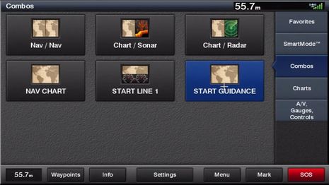
I saw a brief demo of Start Guidance when Garmin introduced a slew of 2015 products in Lauderdale, and I’ve been bugging them for more detail since. Last week they gave me access to an in-house video along with permission to publish screenshots of it. So what you’re seeing here is not necessarily the finished software — for instance, Start Guidance will probably get its own icon instead of the Chart icon used above — but what follows certainly looks like a good start :-).
Incidentally, Garmin already offers sailors the Wind Gauge and Race Timer seen in the Start/Gauge combo screen at top, as well as layline and wind rose chart overlays, and I understand that Start Guidance is a combined effort of Garmin and Nexus Marine engineering.
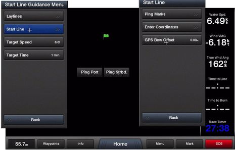
Start Guidance is just a blank screen until you specify the ends of the start line, but that seems fairly easy. You can enter their Lat/Long coordinates if the race committee has divulged them, or you can ping the marks by sailing your bow as close as possible to them (first having entered the distance from there to the MFD’s GPS, internal or otherwise). During this time before the race you’d also determine your best speed and angle to windward (layline) in the prevailing conditions and enter those into Start Guidance if they’ve changed from the previous race.
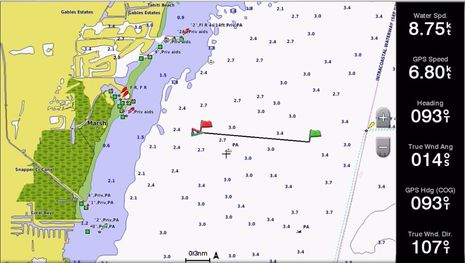
Once the ends of the start line are established, the line itself will pop up on even a chart window. But the really useful info is the visualized timing and vector math that will go live in Start Guidance.
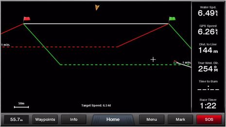
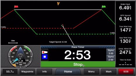
First there are the dotted lines showing where you might want to be at a user-set target time before the actual start, depending on which tack you plan to start on. This is what an experienced racer already visualizes mentally, though potentially more accurate. Note how the line furthest from the start automatically indicates the favored tack. So in this particular case — 22 seconds before the 1 minute gun — the demo racer seems to be jockeying for the most desirable favored pin position. There’s apt to be a lot of traffic in this area, so having the timing presented so graphically may allow the helmsman, navigator, and/or tactician — who all may be one person — to focus their attention on other important matters.
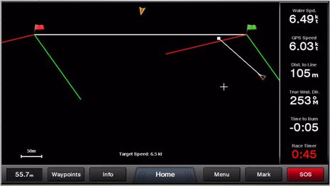
Once the 1 minute gun fires, the dotted lines vanish and the focus moves to the start line itself. Actually, Start Guidance will show you “Time to Burn” whenever you’re headed toward the line, but here’s when it gets critical. The demo racer needs to make up 5 seconds — as shown by both the white heading line and minus burn number — but seems in good shape otherwise.
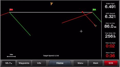
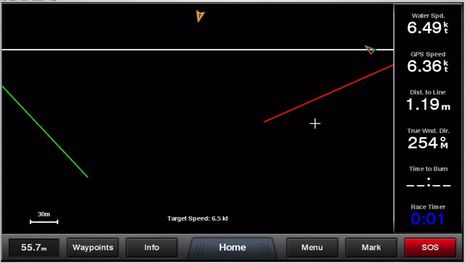
Indeed, it seems that heading up a bit got the virtual racer a sweet 2 seconds to burn with 36 seconds to go. Of course, all this graphic goodness is dependent on good GPS, wind and speed sensors, as well as accurate line-end measurements and speed/angle performance estimates, not to mention successful collision avoidance. But that’s all possible, and maybe the Garmin MFDs that support Start Guidance could even declare, “Well done!” if you cross the line with the 1 second perfection seen below.
I believe that Start Guidance will be included in all the new Garmin GPSMap 74xx/76xx series and will also come to 8xxx and maybe 74x MFDs as a software update. The B&G H5000 that Kees covets can already include a similar (though less graphic) start line screen, which I saw working well on the water, but maybe Start Guidance will encourage B&G, Raymarine and others to develop similar software for their MFDs. I’m not suggesting that a little software can duplicate the very sophisticated features of a high-end racing system like the H5000, but isn’t it great that the feature seen here seems doable on most any modern display?


Terrific! Every sailing feature added to an MFD is a big plus, and maybe this would help get more sailors to come racing.
Very Very Cool!
Some questions for Garmin if they are watching this thread …
I bet an ultrasonic wind instrument would be real useful for a feature like this, absent that, is there some attempt to smartly (e.g. more sophisticated than damping) smooth out the apparent wind measurement? Can it be adjusted or turned off for people who have great wind instruments like the Airmar’s that provide a steady reading even in lumpy seas, and would suffer from additional damping?
How does this feature know the most favored tack? Do I enter the location of the upwind mark in addition to the starting line marks?
I sail in long island sound, where set & drift are a big factor in reaching the starting line at the right place and time. Is correct results contingent on there being zero set & drift, or does the Garmin take set/drift into consideration in it’s calculations and graphics of the start area? Can I provide set & drift to the Garmin manually or does it use the set/drift the MFD calculates from instruments?
Is the best angle to the start line (provided before each race) the overall for the boat in the current wind speed or measured pre-start. Is this a way of incorporating current at the start line if current isn’t supported outright? Does the user enter the best angle once, or once each for port and starboard approach? Is it automatically adjusted if the wind direction changes?
This is great! I still remember setting courses based on LORAN info with hand bearing compasses. I’d love to see this software extended, in the future, to help with long distance route planning while cruising. It would be great to be able to plot a normal course, and then have the software make recommendations on when to tack to most efficiently reach your destination. When I’m doing a 500+ mile passage, having this info could shave a few hours or even a day from the trip. There is PC software that can do this today, but having it on the MFD would be wonderful!
Dan, Garmin bought the best non-ultrasonic wind unit with their Nexus purchase. It is also wireless and NMEA2K, so most racers are happy without the ultrasonic wind. I can’t wait to put the airmar ultrasonic speed depth unit in.
The funny part is most of these features are already out there on iPads and Android tablets, to me this is just catchup for Garmin et al.
Thanks, Anon, I meant to mention racing tablet apps, but I don’t think “just catchup” is a fair description. I’m looking at the iRegatta start line features, for instance, and don’t see anything like the neat 1 minute line then start line sequence Garmin developed:
http://www.zifigo.com/?q=node/644#startview
Is there any app or PC program that does similar two step start timing? Also, to run iRegatta or similar you have to install a possibly complex NMEA to WiFi bridge (though GoFree and Vesper are easy) and you end up with a hard-to-see tablet in the cockpit. The Garmin solution is bright, fast, fixed, and looks very easy to use and understand.
Dan, Garmin MFDs can calculate Set and Drift…
https://panbo.com/assets_c/2014/08/Garmin_Wind_page_2014_cPanbo-9926.html
… but I doubt Start Guidance uses that info and see no way to enter it manually.
It’s the simple nature of the 1 (or 3 or 5) minute timing lines that indicate the favored end of an upwind start line. Picture a situation where the wind is perfectly square to line. The dotted starboard and port tack 1 minute lines would be on top of each other, with no favored upwind end. If the wind shifts right, the starboard 1 minute line get further from the start line and indicates favored tack, as in the demo screens. Or vice versa.
So, yes, the vector math graphics are live, and also probably less laggy than many WiFi app solutions. Though let’s also note that anyone with this Garmin MFD feature can also see/run it from a tablet or phone using Garmin’s free Helm app ( http://goo.gl/PHHnwE ).
I admire what many apps and WiFi bridge developers are doing, but the competition is tough. Nexus racing expertise + Garmin hardware and interface expertise probably add up to a lot more than “catchup” for many sailors.
Deckman/expedition etc have been doing all this for years, but this is the first to be unveiled on an MFD
Thanks, Tom. So that graphic X minute timing line is a standard feature on the high end racing programs?
I saw this in METS Amsterdam and I talked to one of the engineers behind it. He explained the following:
The one minute guide lines (you may set other times) will tell you how long time it will take to the line sailing closed hauled. The green line is for a starbord start and the red for a port. The distance between the line will tell which end is favorable. If the green line is further away from the start line, the starboard end is the best. The distance between the red and green lines will also tell you by how much. So a safe way would be to sail along the green line (if you chosen a stb start) back and forth until it’s one minute to go, then just steer to the line.
The guidelines are using the speed and TWA you entered prior to the start. By sailing closed hauled towards the line and read the numbers (of BSP and TWA) and then enter these in the MFD as you targets.
The white line pointing forward from the boat will tell you how far you will get on the current speed and course over ground on the remaining time to start. If you will be over early, the line turns red. Since this line is based on SOG and COG, it will take current and leeway under consideration.
The time to Burn may also be available as a data field and presented as a number but it seems a lot easier to get a visual presentation of it.
I’m rally looking forward to go out and test this once it is available….
In the pc applications you get a moving line showing where you would be from the line (along the starboard layline) if you had 0 seconds to burn. The idea being to accelerate and get yourself on the line as it moves towards the start.
From what I can tell, the garmin display shows you where you should be 1 minute before with 0 seconds to burn.
It is also worth pointing out that this burn number is a total finger in the air number and is a bit of a gimmick. I guess they are using the current speed vector to show where you will be at the gun.
High end b&g systems use a start polar diagram (i.e. a polar without spinnakers) and a look up table for rate of turn and acceleration to give you time to the line and time to burn.
Shame they are not showing line bias and how much advantage there is to be at the biased end like the H5000 system does. IMHO line bias and distance behind the line are the two most important bits of info (and time to go obviously!)
Again, go garmin! I can really see the Garmin graphics above making it a no brainer and a win for the skipper of a boat to be close to the race start frequently. I remember times when I was a minute late to a start, and condemned my racing crew to a poor finish before we even started.
In reply to Tom, start polar diagrams and such feature sets that approach what can be purchased in the high end b&g systems would be welcome. Perhaps a better implementation, then on-boarding all those smarts to a consumer MFD, would be to mimic what’s happening with automobiles where the GPS style car displays become remote terminals for your smartphone. Rather than the turn by turn instructions and traffic information coming from the smarts in the car display, the display is a remote terminal (touch screen and all) for your smartphone. Then these monthly innovations in google maps continue through the life of your car, the sailing equivalent would be for b&g like applications to be downloaded into your smart phone.
In reply to anonymous, does the non-ultrasonic wind sensor you speak of filter out noise in apparent wind measurements from mast motion like the Airmar does or the H5000 does using information from a motion sensor attached to the mast?
Garmin let me know that they are monitoring the questions here and hope to provide some follow-up, though probably not until after the holidays.
The starting line functionality is great but will it be possible to set the course – i.e. a windward leeward course, 2 NM, 160 degrees? The starting line is nice but where do you go from there?
@Ben. Short of hands-on with a H5000, check out Will Oxley’s Modern Race Navigation. Its got an entire chapter on Expeditions start line capabilities. Also a lot of great information re: favored sail race instrument kit.
Re: ultrasonic wind and hull speed. Neither is in favor with the sail race crowd. See the discussions on Sailing Anarchy.
Re: Garmin and the sail race market. The Nexus rep in Pacific NW is fabulous. But the sail race market is such a small sliver of Garmin’s biz that I doubt a long term commitment. I am happy to be proven wrong, but I see little Garmin presence in sail racing’s top events.
Thanks, Sparky. The Oxley book — which anyone can check out here http://goo.gl/WHtns4 — looks neat. But he’s a pro and that is a very, very small sliver of the market.
I think that Garmin is going after the much larger market of amateur racers, cruiser racers, club racers, etc. So is B&G with the Zeus sailing software features. Meanwhile, Raymarine has “owned” that market for a long time and I’m sure we’ll see software features like Start Guidance coming to their machines too. I wouldn’t worry about commitment because NMEA 2000, all-in-one instruments and powerful MFDs has made these features relatively low cost.
Jim V, Garmin MFDs have been able to show laylines to a waypoint for some time so if you put the race marks in as a route you’ll at least get layline guidance overlaid on your chart.
A lot of Garmin sailing features are not available on an MFD unless you tell the MFD it’s on a sailboat, which is somewhat similar to rebadging Simrad MFDs as B&G and loading in some sailing features 😉
Re: Oxley and his colleagues being a pro and Garmin going after the amateur race market. Its exactly the Oxley’s of the world that Garmin needs to engage if they intend to be viable in the amateur sail race market. The trickle down experience B&G brings from their grand prix efforts is important.
Jim’s example is typical. We usually have little time to bang a multi waypoint course route into an MFD when a course is posted and the start sequence begun. But the ability to provide start mark, geometry, distance and bearing to first mark … then have the entire route formed and the unit started navigating along it … now you are talking. Just one of many use cases specific to the sail race market.
Sparky, I have not used a Garmin while racing, but have used the classic Raymarine E-80 (circa 2006) and curious what the challenge is on the Garmin.
I maintain a bunch of waypoints of the various fixed racing marks in my sail area. At the start of each race I navigate my sailboat passed each of the floating marks, add them to the MFD, and after the race is posted use the build route function in under a minute, then choose follow route. Seems pretty simple as long as someone else is at the helm while I do that. No start line feature, but it helps me make navigation decisions otherwise.
In case it was glossed over, I would again submit that it would be highly useful to novice and even moderatly skilled helmsmen/tacticians if the set and drift at the start line could be manually input as part of this race starting feature in the Garmin.
@ Dan. I do similar, but this only works for fixed marks. All my race tracks are pre-loaded into my MFD prior to race day. The MFD comes home for this. Why you might ask? Because I’ve generally found the route planning apps and subsequent transfer of user data (waypoints and routes) into the MFD is STILL a miserable experience (I’m looking at you Garmin BCM and Navico Insight Planner).
Back to the point. Once in the starting area, a position update to the START mark is needed. Gun fires, start the selected route … mostly good.
Another issue here however is the ability to start a route to a specific waypoint or a leg of a route. Many MFDs do not support this. When the gun fires, I want the MFD navigating versus the first leg (for XTE), not the start mark.
All that said, none of this works for drop marks with fixed course geometries (which I believe is the point of Jim’s question).
Garmin is a new upgrade:
Changes made from version 3.80 to 4.00:
Support for 2015 products including GHP Reactor autopilot and new GMR xHD2 series radars.
Added auto guidance features that allow for inserting via points, reviewing hazards, and displaying optimal speed to arrive at a desired point.
Added support for bird mode and echo trails with new GMR xHD radomes and xHD2 open array radars.
Added DownVü split zoom sonar page.
Added SideVü split zoom sonar page.
Added support for importing waypoints, routes, and tracks from GPX files.
Added support for synchronizing the startup wizard.
Various other performance improvements and bug fixes.
Kris
Thanks, Kris, but let’s also note some of the other changes 4.90 to 5.00 means for the 8000 series:
Improved home screen with easy access to commonly used items – Favorites, Functions, Combos, and SmartModes.
Improved SOS safety with a list of SOS types and a script to read over the VHF radio.
Added support for importing waypoints, routes, and tracks from GPX files.
Added owner’s manuals PDFs (Info > Owner’s Manual) and support for displaying PDF files on an SD card.
Added ability to customize/resize the layout of functions in a Combo or Smartmode page.
Added sail race virtual starting line, time to burn, and synchronized race countdown timer. { discussed above }
Integrated support to view and control compatible Axis® IP cameras and encoders (up to 4-channel).
Added dual radar support (1 radar displayed per unit).
Added support for bird mode and echo trails with new GMR xHD radomes and xHD2 open array radars.
Much more here:
http://www8.garmin.com/support/note.jsp?id=4749
I discussed some of these features when Garmin introduced its 2015 line in Miami…
https://panbo.com/archives/2014/10/garmin_2015_glass_bridge_7600_series_reactor_autopilot_xhd2_radar_more.html
…and I think they will also apply to the new 7600 Series.
But note too that this update is apparently incompatible with the Garmin SonarCharts that Navionics is experimenting with.
I’m on my boat and will write about the SonarCharts and the update soon.
Watching for Garmin’s reply to the questions in this thread.
Hi Dan, I updated Garmin 8212 and 741xs today and thought of you. There’s a “correct for currents” option in Start Guidance and also for Laylines.
Very impressive.
Raymarine adds sailing features with Lighthouse II version 14. Big time:
http://www.raymarine.com/view/?id=8291
Very welcome, racing starts tomorrow.
Ben:
Does your comment mean the 741xs supports the starting line guidance features? Garmin just told me earlier today that those features would only be available on 7400/7600, 8000, 8×0/10×0 models. I specifically asked about the 5×7 and 7×1 and they said no.
Eric, if you mean this line in the entry…
“I believe that Start Guidance will be included in all the new Garmin GPSMap 74xx/76xx series and will also come to 8xxx and maybe 74x MFDs as a software update.”
…sorry, the “maybe” turned out to be not. I was guessing based on the software lines, which are unfortunately somewhat forked at Garmin now. Today it’s Raymarine that has ALL its current MFDs running on the same code base, so its new sailing features apply across the board.
That was what I had seen. Too bad.
Thanks Ben!
I am having problems with these two new sailing features in LH 14 on my e125 MFD. Is anyone else experiencing it ? I have posted these to the online technical forum three times, and it does not get approved.
Features described here
http://www.raymarine.com/view/?id=8291
1) The feature to “see how long to go” to the start, does not seem to be in the release. I take it to mean an estimated time to start line based on current speed. How to get this to display?
2) The laylines that are displayed, appear erratic. They redraw every second or so at much different angles, e.g. 20 degrees or more. I have a very stable AWA measurement in my Airmar Weather Station, that I would think provide a very stable estimate of where the lay line is.