
More Ray LightHouse II goodies: Sounder Select, GPX, DSC, PDF & Fusion-Link
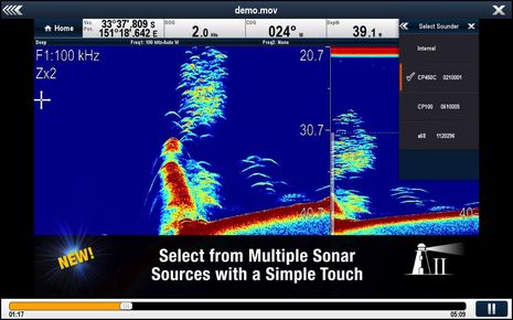
One of many features in Raymarine’s latest software update (besides the just-discussed LightHouse charts) is support for multiple sonar sources. While I didn’t have the hardware or even the working vessel to test this, it’s neat that the demo video I screenshot above is built right into the LightHouse II update (and actually more detailed than the one currently on YouTube). But who needs multiple sonar sources? I know that some readers may perceive it as feature glut, but not I, and I’m not even much of a fisherman…
 The major manufacturers seem to be working hard to bring CHIRP improvements to even modest fishfinding hardware and also to the structure detail of high-frequency narrow-beam down and side scanning. I find the latter particularly useful for gunkholing and just plain interesting to keep an eye on (explanation here). And let’s hope that Simrad ForwardScan is not the only integrated forward looking sonar in the works. These new technologies are being delivered as black boxes or built right into even small MFDs — often at little added cost — and after that purchase/install it’s just a matter of installing a new transducer (like this ForwardScan or this Ray CP100 DownVision), plus having a software switch like the one shown above. Then all your MFD screens can have new ways to see underwater.
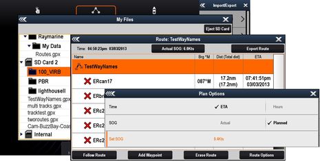
The LightHouse II feature list also claims new support for GPX format waypoint files, and I found out that it includes importing and exporting GPX route and track files as well. Those waypoint names in the route TestWayNames, for instance, were quickly typed into Coastal Explorer running on a PC. There are also planning improvements like the ability to set a planned SOG or see leg times either as hours or as ETAs. I still don’t think that any MFD has the planning abilities of CE or other PC charting programs, though. (But then again, I think we’ll soon see a combination of Navionics Mobile auto-routing and auto-syncing with Ray MFD’s that’s going to be very attractive.)
Plus a Raymarine MFD system can also now handle up to 3,000 waypoints, 150 routes of up to 200 waypoints, and 15 tracks of up to 10,000 points. There are also more waypoint symbols to choose from, and you can search and save waypoints by area, all of which will be appreciated by aggressive cruising navigators and fisherfolk.
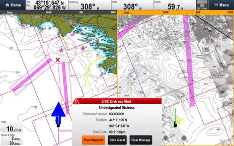
With LH II, Ray MFDs also get some level of “DSC support over SeaTalkNG/NMEA200,” though I’m hesitant to publish this screenshot. I should not have been messing with a DSC Distress Alert, even from a handheld radio in my mostly underground basement lab, and I was so quick to cancel it that the MMSI apparently wasn’t received. But if this was real, wouldn’t that be a screen alert that could lead to a speedy rescue? The receiving radio was a Simrad RS-35, and while it seems to perform most DSC functions very well (review to come), I haven’t yet figured out if it will receive individual positions from another manufacturer’s DSC radio with its “Track your Buddy” function, or whether they’ll plot on LightHouse II.
It’s not at all new, but note how Raymarine let’s you show blue Tidal Current and/or yellow Wind vectors (as well as COG and/or Heading vectors) customized for different chart windows. Note also that fat current arrow is because the simulated boat was doing 30 knots over the ground (SOG) but only 2 through the water (Speed or STW)…
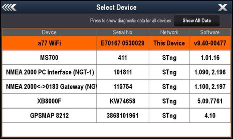
In my experience, Raymarine has always been behind the competition in diagnosing NMEA 2000 networks and selecting a preferred data source when there’s more than one. But every version of LightHouse gets better, and I was pleased to call up this detail on a small but very mixed network. The manufacturer’s names would have been nice, too, but FYI the list is Raymarine, Fusion, Actisense twice, Vesper Marine, and Garmin. And it’s the NGW-1 NMEA 0183-2000 Gateway that does the work of translating 0183 GPS, Heading, Depth, Wind, Speed and other messages from SailSoft’s powerful NemaStudio simulation software. I can cruise anywhere on the lab’s MFDs even while Maine still suffers through a too long spell of ice and frozen snow.
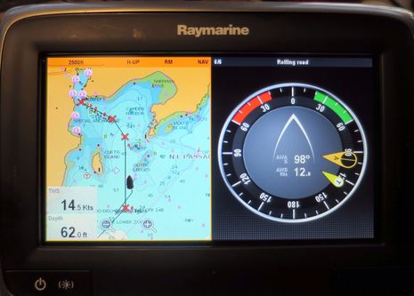
Now for some features that arrived before LightHouse II, but that I hadn’t tried yet, like that handsome Apparent/True wind gauge above. To get it to fill an entire window on the a77 screen, I had to put it in the preconfigured single item Rolling road window, but doesn’t it look sharp, especially now that LightHouse II can autohide the top databar? I still wish Ray offered a side databar alternative, because the autohide can get a tad annoying when you use menus much, but note also how much chart ahead you can get in head up mode with vessel offset.
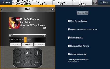
I also tried Raymarine’s version of Fusion-Link, which came with LightHouse v6.27 a year ago February (revision history here). It can’t do all the deep setup tasks like naming zones that Garmin’s Fusion-Link can, and I don’t think that even the basic controls are quite as functional. Note, for instance, the tiny type on the source choosing bar, which doesn’t get any bigger even if you run the Fusion app full screen. But, cripes, it is a free stereo interface if you already have the hardware, and thanks to the Ethernet connection it does include cover art. Plus, it turned out that Ray has gotten quite liberal about how you set up Ethernet.
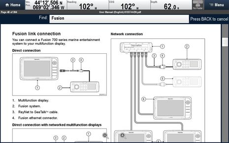
I thought I might need to use a switch or a Crossover Coupler, but that was old SeaTalk HS thinking. It was especially nice that I could confirm the greater flexibility of RayNet architecture and the Fusion connection specifically by searching the manual PDF on the Raymarine e127. I ran a Raynet-to-Raynet cable between the two MFDs and Raynet-to-RJ45 to the Fusion IP700 and it all just worked. I know that some advanced users also want the same network to go their boat’s WiFi router so they can also use Fusion apps without changing the WiFi source, and I learned in Miami that Raymarine wants to make that happen, too (though they made no committment to when).
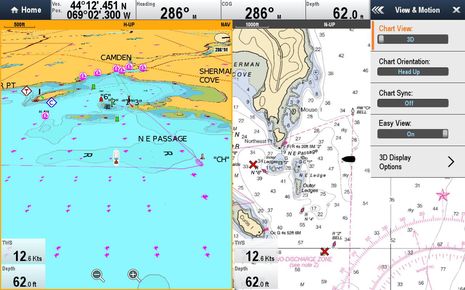
So LightHouse II and the whole rapid development of Ray’s multi MFD software looks good to me. But I will close with a couple of complaints, illustrated below. For one, I’m surprised that the Navionic 3D mode still doesn’t default or even option to look ahead mode (like every other developer’s 3D mode). A prime advantage of 3D is seeing detail around and just ahead of your boat while still seeing some detail further ahead, but putting the boat in the middle of the 3D screen reduces all that and emphasizes the detail behind you. It also bothers me that the otherwise useful data overlays that you see at the bottom left of both windows below can’t be customized for each window, like many other features can. Am I in the minority for thinking that dual head-up windows are the norm in this world of wide-screen displays?


Thanks Ben,
These look like good improvements for my e7.
Your pic of true and apparent wind reminded me of one thing that bugs me about the e7, though. I chose not to install a speed transducer, since it’s one more through-hull. To calculate true wind as a vector sum, the e7 obviously needs speed and apparent wind. But in most cases, the SOG and apparent wind will give a pretty accurate picture of true wind direction. But if there’s no speed transducer, the e7 won’t give even an approximation of true wind. It would be nice to have just a quick at-a-glance idea about true wind, even if it doesn’t take current into account and just uses SOG. As it is, I do the vector sum in my head, but a quick approximation on the e7 would be nice.
Hi Ben, nice work. I can’t find a chart offset function in the menu of my A78 MFD? My tracks, imported from my old A50, still show me on land in many of the remote islands off the West coast of sumatra. Is there a solution in lighthouse II, I have updated the software on my A78 MFD and using navionics gold latest chart and updates for south china seas, Indonesia and India.
The Raymarine rep in Perth could not find any chart offset function either. It worked great in the A50, the rep said it was unsafe to use it as you may forget to switch it off, but it unnerving to be following a track and sailing over land on the chart!
Cheers from Keith.
Brendan,
You’re right that in most cases SOG can sub for water speed. The problem is that when it doesn’t (fast currents plus slow boats), it can mislead you quite badly. When I design a system, I always go with the maxim that no information is better than bad information and it sounds like Raymarine does too.
Hi Brendan & Saffy, I wish I’d written “True Wind Relative to Water” when describing that gauge because that’s what Ray means. It’s truly a shame that our world is stuck with the term “True Wind” when it has two valid definitions.
We’ve discussed this at great length on Panbo and I ended up thinking that the term True Wind should be dropped altogether in favor of Water Wind and
Ground Wind. Then we could all use the sensors we have without getting tripped up by confusing terminology!
But let’s please not let this thread devolve into another True Wind debate. Please go here instead: http://goo.gl/g74NnN
Hi Keith, I don’t see anything about chart offsets in the new a-, c-, e-Series manual, but I tend to agree that it’s a dangerous feature that shouldn’t be needed anymore anyway.
You can still change GPS datums but that should only be necessary with some paper charts which still haven’t gone to the WGS 84 datum that is universal to electronic charts (I think).
Ben and Saffy,
Fair enough. Those are good points. Even though I’m a regular reader, I wasn’t aware of the “true wind wars”…
More to the point above, though, the multiple sonar sources thing is nice. I’m in SW Florida (the grounding capital of the world), and when Ray comes out with a forward looking sonar I’m gonna be very interested in adding it. Even 8x current depth (like the Simrad model) would be useful, although I wish it were even more, obviously.
Ben,
if you program the speaker zone names into the Fusion700 directly, those labels will show up on the Ray device with the Fusion interface.
Right you are, Bill, but it’s great to use the touch keyboard on the Garmin to type the names instead of using the rotary knob on the Fusion. Definitely not a big deal, though.
Can one infer from the acceptance of multiple sonar sources, that multiple “other” sources options such as GPS etc. are just around the corner?
Don, Raymarine has tried to offer NMEA 2000 (SeaTalNG) source selection for some time, though it’s never worked on Gizmo’s fairly large and many manufacturer network. But, as noted above with that “Select Device” diagnostic screen, it keeps getting better.
On that mixed, but small network, I can tell the Ray MFD to automatically choose between the Actisense NGW or Vesper XB8000 as a GPS source or manually select one as the source. In my experience, Ray gear has always tolerated multiple sources, simply locking on the one seen first, I think, though unable to tell you which one that is.
I think Raymarine uses the device with the lowest address claimed. Nobody seems to do source selection anywhere nearly as good as the Navico brands where you can select chosen source for nearly all the data types/categories
Thanks Ben.
I will contact navionics about the chart source for their areas that show my tracks on land!
Cheers from Keith.
If you want to know what GPS source the Ray has currently chosen (and currently using) simply goto the system settings and look at the active satellites. Under that graphical display, directly underneath the graphic, it tells you, ie, “Internal GPS, STNG Raystar130”, etc.
I finally got out to SF Bay and the boat, and project #4 was to update the firmware in my Raymarine system, starting with Lighthouse II in the e95.
Naturally, I discovered 9.45 was out AFTER I spent forever loading 9.40 onto the mSD card.. with a type 4 card, it takes a while!
Loaded it up, then loaded 3 sets of NOAA raster and vector charts onto a 32 GB card (which took even longer).
Everything worked, amazingly enough – though I wasn’t pleased that the NOAA charts stop showing bouys at my favorite level of wide zoom. They do have the channel markers at Emeryville in the right place, however.:-) Navonics has them significantly out of place.
FWIW, RayMarine informed me today that version/Release 10 is out for Lighthouse II. It seems to involve sounder stuff (which doesn’t apply to me) and requires that the sounder firmware (if you have one) be updated first. The web site is so insistent about it, I have to think that updating your MFD without doing the sounder first will probably fail in some spectacular fashion..:-)
Something else to do next time in San Fran…
Perhaps off topic has anyone tried the Garmin Meteor audio system? It sure reminds me of my FUSION?
Thanks,
Bill Lentz
Wireless Too
1976 Gulfstar 36 MKII trawler
Middle River, Md.
Wireless One
1993 Mainship 40SB
Little Egg, NJ
Bill, I haven’t tried Meteor but I suspect that the interface looks very much like Garmin FusionLink, which is quite nice and detailed here:
https://panbo.com/archives/2014/03/fusion-link_n2k_garmin_happy_together.html
In fact, Fusion definitely builds the Meteor for Garmin, and Garmin just acquired Fusion! Please see recent comment and link at end of that Garmin Fusion entry.
Ben, and all I my Garmin Meteor system just arrived. I’ll report on it after it gets installed in my new to me Gulfstar trawler.
I have also been beta testing the new Wave EC N MIMO product. I’ll report on that soon as well.
Bill Lentz
Wireless Too
1976 36 Gulfstar trawler