
Improved current data? Let the IHO know you care.
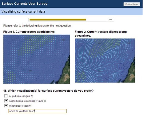 Maybe you, too, have an opinion about how predicted currents should be overlaid on electronic charts? Well, the International Hydrographic Organization (IHO) is developing an S-100 specification for “the delivery and presentation of navigationally significant surface currents” and right now they’re running an online survey of all interested parties. What waters do you care about (coastal for me)? What prediction frequency would you like? Are you willing to pay? How should the data look? And more…
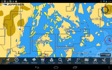 Now maybe you’re thinking that current predictions are already pretty well displayed, and I wouldn’t argue, but what’s wonderful about the IHO’s interest is the prospect of a standard that might encourage the collection and distribution of better data. In other words, the current arrows on whatever charting software or multifunction display you use may look good, but I hope you know to treat them cautiously. I only had to open the app above to get a good example. Those arrows vaguely represent what the tidal currents are doing in my cruising neighborhood as I write, but with the emphasis on “vaguely” and much more, so as you drill down on all the coves and byways that drain and fill with about ten feet of water twice a day.
Those arrows do represent the same NOAA tidal current stations that most every other provider displays, but they are not nearly dense enough to cover hydrodynamics as complicated as this coast. Plus, by definition they predict nothing about other surface current factors like big storms offshore or particularly robust river and stream outfalls. And, incidentally, this section of Maine has more than a normal share of NOAA tidal current prediction stations. I had a devil of a time figuring out the strong currents I found along the Intracoastal Waterway last fall and spring and though I’m in a powerboat these days, currents still matter a lot (at the efficient, peaceful speeds I prefer). I don’t know how finer grain surface current info will get collected — satellites? crowd sourcing? — but I’d sure like the IHO to know that we care. Besides, the survey is short and interesting.
By the way, the app above is Jeppesen Marine Plan2Nav for Android, which is looking good in V1.1. For instance, the now available Active Captain cruising info pairs very nicely with the C-Map C-Marina chart detail. AC was also where I heard about this IHO survey, for which I’m grateful.


To be perfectly clear, I think that Plan2Nav tidal current predictions are as good as anything similar.
That said, Plan2Nav does not (yet?) let you see predictions for future hours and days, but it’s got a lot else going for it.
MaxSea/Nobeltec TimeZero has high resolution tidal currents (for US & Europe). TimeZero also plays a prediction as well. Further to that, TimeZero has a downloadable snapshot of oceanic currents for the previous day (00:00UTC).
In your dreams, thedon! I’ve used Maxsea/Nobeltec TimeZero quite a lot — as well as NavNet 3D, TZT, and the TZ app (love them all) — and have never seen U.S. tidal current resolution better than the same flawed NOAA data that everyone else has. Europe I don’t know about, and while the free MaxSea ocean current (and weather) model data is neat stuff, it has nearly zero relevance to coastal cruising, I’m pretty sure.
I’ve never understood why we can’t be progressing toward a system of buoys with all sorts of transducers for weather and sea state which upload the data real time and it can be then accessed via internet or some other broadcast technology so mariners could have real time data on board.
Most of the reports of weather buoys in LIS seem to not be reporting (malfunctioning?) so the NOAA reports don’t have this data.
The net can provide access to vid cams all over the place. Why can’t a similar technology provide this data?
But yeah… the algorithm showing currents and tides seem mickey mouse and unreliable with my ray GPS chart plotter.
Well, weather buoys like that are darned expensive to build and maintain. I think we’re lucky — especially in these days of “making government so small you can drown it in a bathtub” — that many research facilities are sharing the task with NOAA. For instance, we have the fabulous F01 Penobscot Bay buoy owned and operated by our state U:
http://neracoos.org/datatools/realtime/all_data?platform=F01
I use that data regularly but the least useful may be the current speeds and directions, though I suspect those may be the most expensive sensors. The problem is that there’s little relationship I know of between the current speeds at that particular spot and elsewhere. Current measurement and prediction is hard!
Tide predictions, incidentally, are a different matter. The predictions are pretty accurate and the real world effect is not radically different at nearby spots. (Though this less true in areas like the Florida panhandle where where relatively weak tidal forces vary from semi-diurnal to diurnal and weather plays a much larger role in surface currents.)
LIS east-west surface currents are greatly affected by wind. Take the Ray results and factor in a delay based on the wind direction and speed Ray reports by + or – 15, 30, or 45 minutes.
Yes, of course with funding cut backs this is not likely to happen, unless some of the waste, fraud and abuse is applied to civilian projects such as weather and sea data collection around our shores.
I’m sure some high tech company could produce a device attached to existing buoys which could do this. But the only customer would be the USG and so there is not much incentive to develop them.