
Smart Chart AIS needs our help, Uncle Sam’s too!
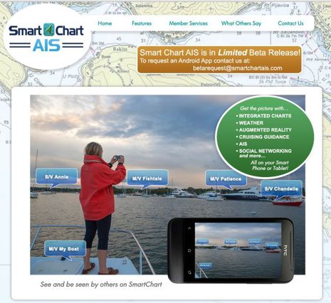 The first Smart Chart AIS app, a result of the very interesting U.S. government-funded Class E AIS project discussed here last August, is looking for 100 Panbo beta testers. Volunteers need to have an Android smartphone or tablet and should be boating in U.S. waters or at least spending time on the coast. Here’s the Smart Chart web site and here’s the beta sign-up site. Beta feedback will happen on the SC forum, not in this entry’s comments, please. I’ve been in the test program for a few weeks and will illustrate some of the app’s features below. I’ll warn you, however, that there’s a major disappointment, which has nothing to do with Smart Chart’s developers…
As originally conceived — or so I perceived — the Smart Chart AIS app would include the U.S. Coast Guard’s Nationwide Automatic Identification System (NAIS) coverage of Class A and B vessels along our coasts, which far exceeds the work of shore-listening volunteers and sites like Marine Traffic (I’m pretty sure, though I’ve never seen it). It made total sense. The Department of Homeland Security (DHS) funded the Smart Chart AIS project so that small boats would voluntarily submit their tracking information to improve on NAIS’s stated goals of national security and maritime safety. And while the free Smart Chart app is going for numerous features that will be attractive to boaters, the one that would be truly unique and must-have for many is the NAIS coverage. Skippers using apps like Boat Beacon and Seapilot, which bring shore-collected AIS info to an online boat, say that it improves their situational awareness, and — let’s be honest — there’s also an enjoyable social aspect to AIS. I use Marine Traffic all the time (like here) to keep an eye on boating friends and “vessels of interest” (my definition being different than DHS’s). Class E AIS could expand the safety and social uses of the system tremendously, without interfering with the VHF-based Class A and B system a bit, but it may be slow going unless adoption is encouraged with a very tasty carrot.
I think that A, B and E AIS all integrated on a phone or tablet app could be that carrot. And remember that the SC app is just the beginning of the Class E project; eventually, the plan calls for an SDK so that any developer can tap into the system as long as their app delivers the user’s ID and tracking info back. So, why can’t one branch of DHS pass along NAIS info to a project sponsored by another branch? Especially given that AIS data is now widely acknowledged as public information broadcast over public radio spectrum (and I understand that the EU has instructed its governments to share the data they collect with AIS distribution businesses)? Apparently, there’s some sort of legal snafu that’s so far unsolved. If you have friends in high places at DHS, please make the case 😉
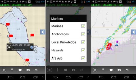 At any rate, the Smart Chart AIS app is currently using AIS data from AIS Hub. In fact, the targets seen in Camden Harbor yesterday — yes I agree that the target icons should be scaled larger, but that’s the sort of comment we should save for the Beta forum — are coming from my simple home receiving station. While AIS Hub coverage is pretty thin for the U.S., the screens above show some of Smart Chart’s other attributes, like NOAA ENC charts, ActiveCaptain cruising information (which has indeed become ‘huge’), and NEXRAD weather radar…
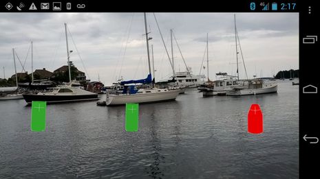 Technology Systems Inc. (TSI), the developer behind Smart Chart AIS and the Class E project, have long been innovators in navy-grade augmented reality and once took a crack at the big yacht market with the impressive LookSea system (PMY article still alive here). So, it’s no surprise that when Smart Chart sees accurate GPS and Heading info, a novel AR mode is enabled. The ENC nav aids display seen above has already been improved with range and icon size controls, and TSI developers are working hard to make ActiveCaptain and AIS augmented reality work smoothly. You can help by joining the beta program.
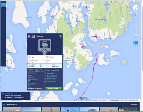
You can also help by putting up an AIS receiving station, seeing as the NAIS issue discussed above may not get solved, no matter how much I stamp my feet (we?), and may not ever get onto a free website, anyway. Note the clean new Marine Traffic interface below — in beta now, but live soon — and also that MT was purportedly tracking 74,301 AIS vessels when I took the screenshot Tuesday evening. The public AIS tracking cat is way out of the bag, so let’s make it better. Note too that the “AIS Source” in this case is M/V Gizmo; I’ve managed to create an onboard volunteer receiving station before, but now it’s much easier, thanks to the nifty WiFi abilities of a Vesper WatchMate Vision, which I’ll review soon. I think we’ve just begun to see what A, B, and E AIS can do for us, but what do you think? And feel free to rant about government intrusion into our privacy, but isn’t that cat way out of the bag, too?


Ironic! I thought I posted this entry this morning when we were anchored on the north end of Bartlett Island with a wonderful Verizon LTE connection. But I must have missed the last step and then cruised into more typical downeast Maine, 1XRR data at best. Smart Chart AIS doesn’t do well without a good data connection, but fortunately most of the coast south of here has them.
Ben as far as fears about government intrusion there are numerous devices that a US agency can use to track a vessel or people. Your cell phone, any data modems, anything with an IP and MAC address and even silently pinging a vessels DSC.
I like AIS and was one of the 1st vessels in my area to install an AIS Class B transponder. The class E application looks pretty good but I think one should use all tools at their disposal. I have never been to keen on AIS only receiver units other than for receiving stations that put the data on the Internet.
I might want to talk to you about setting up something similar to what you are doing on GIZMO. My area has a hole when it comes to on-line viewing of AIS vessels. I could contribute by setting my vessel up as a receiver.
The vessel always has high speed Internet connectivity in my primary boating area.
Thanks for the latest information on the Class E AIS application and how it relates to boating.
Bill Lentz
MV; WIRELESS ONE
Little Egg, NJ
Thanks, Bill! Setting up a volunteer AIS listening station is pretty easy IF you have an online PC running all the time, and it costs nothing except a tiny bit of bandwidth and some electricity. I wrote about my home setup here:
https://panbo.com/archives/2012/05/aishub_how_you_too_can_put_ais_targets_online.html
I just fired up the boat’s system, which also uses AISdispatcher software with outputs to both AIS Hub and Marine Traffic. It’s raining here and hence a quiet day for AIS (lots of Class B sailboats around who shut down when not underway), but you can see my station stats here:
http://www.marinetraffic.com/ais/stationdetails.aspx?station_id=729
Note the “Add your station” bottom left. That’s where you’d fill in your info and get assigned an IP address. Simple as that.
AIS Hub seems to put my home and mobile feeds into one set of stats seen here:
http://www.aishub.net/source-statistics.html?source=2137
Thanks to my home station I know that I’ll get to see a couple of very snazzy sailing yachts when I get back to Camden later today 😉
PS Bill, do you have an Android device and, if so, have you signed up for the Smart Chart AIS beta testing? Anyone? Of course there will be an IOS app eventually.
Yes I have an Android device the HTC EVO. I will be looking into signing up for the AIS Class E trial once I get to the boat late this afternoon.
Thanks for the links you posted above. I am also going to set up my vessel as a AIS receiving station to fill in the Internet based AIS void.
Bill Lentz
MV; WIRELESS ONE
Little Egg, NJ
I’ve heard that some Panbo readers have signed up for the Smart Chart AIS beta test, but they can use more:
https://testflightapp.com/join/e412413b466e2b1a8073d59f95c21a5a-MTc2ODk5/
(note that the TestFlight link can be unresponsive sometimes, but seems to work eventually)
New version of Smart Chart just out, installed easy. More Beta testers wanted!
SmartChart AIS has been released and is free at Google store:
https://play.google.com/store/apps/details?id=com.tsinc.smartchart&hl=en!
(The iOS iPhone/iPad version is scheduled for release in the Fall.)
I haven’t tried the released version yet but anyone who has is welcome to comment about it here. Thanks!
Installed ap on Droid 3 smartphone.
cannot register me cannot register boat, it just sits there on a blank white screen. Nothing works
It was just unlucky timing, Ted. SmartChart got swamped today because it was touted in the ActiveCaptain newsletter. Their server went bonkers. But they’ve fixed it now and thanks to AC there are a lot more users in the system.