Monthly Archive: April 2013
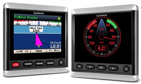
In my opinion it was the Garmin GMI 10 that trail blazed the wonderful world of color NMEA 2000 all-in-one displays, but it’s gotten major competition from the Raymarine i70 (comparison here), the B&G Triton (first look here), and the Furuno RD-33 (hand’s on here). And when Garmin demoed its new 800 Glass Bridge Series in Miami, the GMI 10 also installed on the dash looked decidedly out of place. So it was really no surprise when they announced the new GMI 20 and its GHC 20 sibling last Tuesday. It will be interesting to see if they’ve outdone the competition but that’s hard to judge as these all-in-ones can potentially do so much, though not necessarily exactly what you want…
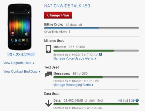
I lucked out. Just look at all the data I’ve been slurping through my Verizon Galaxy Nexus cell phone while living and working afloat. Up until this month I didn’t think that using 21,482 megabytes on a $60 data plan was possible without repercussions — like Verizon throttling me down or even saying “bye-bye, buster!” But apparently it’s perfectly OK for me to keep right on slurping at this piggish pace. Am I enjoying a short term sweet spot?
Since leaving Myrtle Beach on April 1, I’ve spent a fairly ridiculous amount of time messing around with WiFi and cellular Internet connections, and not only is Gizmo quite well equipped in those categories...
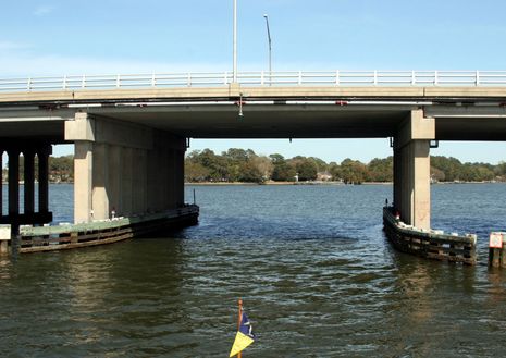
This was Thursday’s little challenge. It’s what I’ve starting calling a “trawler bridge”: a span high enough to let motor cruisers get at some good anchoring and/or gunkholing, but not so high that they have to share it with pesky sailboats. I kid, of course, but I had spied out a great little spot on Norfolk’s Lafayette River (Google Map here) to ride out the frontal passage and it would likely be free because there’s only 24-feet under this bridge at high tide. However, I wasn’t absolutely sure that Gizmo’s mighty antenna farm met that requirement…
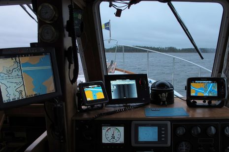
Yes, it sure looks like overkill — and this shot doesn’t even include the iPad that’s often mounted here at Gizmo’s lower helm — but I’ve definitely found ways to put all these screens to work. In this particular scene the boat is crawling out of a very shallow back creek (actually called Back Creek) where we’d hidden from the worst of a cold gusty low that had me wondering if spring would ever materialize. It was still gusting in the high 20’s and that’s only 2.8 feet under the StructureScan transducer that’s fastened to the keel forward. If you look closely you’ll see many chart types, including the C-Map Max format now well supported by Coastal Explorer. The day before I’d gotten a serious reminder about the value of multi charting…
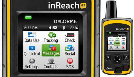
I was so focused on finally heading north that I forgot the April 1 announcement of DeLorme’s new inReach SE, even though one standard step in getting Gizmo underway these days is firing up the original inReach for tracking, messaging, and much more (as discussed here last fall). But my forgetfulness does not indicate a lack of appreciation for the new model (which I’ve already handled briefly in prototype form). To the contrary, I think the SE (Screen Edition) will likely make a lot of boaters as enthusiastic about the whole inReach concept as I’ve already become…


Recent Panbo Comments