
Goodbye dGPS? Hello Virtual AtoNs?
No one should get overly upset quite yet, but it does seem that the U.S. Coast Guard is thinking about reducing the differential GPS (DGPS) correction stations it manages, and is also wondering if all the aids to navigation (AtoNs) it maintains are truly necessary these days. My friend Dean Travis Clark recently joined the Navigation Safety Advisory Council (NAVSAC) and he just sent around two of its working group resolutions for comments. I know he’d like to hear the opinions of Panbo readers too, and that these resolutions have not yet been finalized or presented to the USCG…
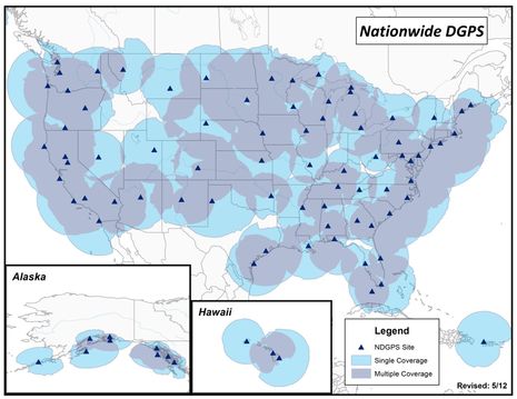
NAVSAC Resolution 12-05 is titled “Continued Maintenance / Operation of Differential Global Positioning System” and you can download it here. Remember that “DGPS” is a confusing term because it’s often also used for the satellite-based augmentation systems (SBAS) like WAAS, EGNOS, and MSAS that are used even by the tiny handheld Bad Elf Pro GPS just reviewed. The more specific DGPS that the USCG looks after in the U.S. is the earlier technology that uses ground stations and medium-frequency radio waves to deliver differential position corrections to an onboard GPS. I used to see yachts equipped with DGPS but not often these days, presumably because of SBAS and the cost of DGPS receivers like the Furuno GP150D.
Frankly, then, I don’t know much about the current state DGPS and how much it’s used by ships and the like, let alone how highly it’s valued. According to the resolution NAVSAC has tentatively concluded that the Coast Guard is underestimating DGPS use because they used the GPS accuracy flag included in AIS transmissions (only Class A can take input from a separate GPS, differential or otherwise) and also that DGPS is more reliable than SBAS. What do you all think? Should our government keep spending 15 million dollars a year maintaining the Differential stations? I must say that 15m strikes me as relatively small money…
I do have more of an opinion about NAVSAC Resolution 12-06, which is titled “Elimination or Reduction in the Number of Physical Aids to Navigation
(AtoN) and Consideration of ‘Virtual AtoN'” and can be downloaded here. I also found some valuable information about what the Coast Guard is thinking. Just go to NAVSAC’s DHS Homeport page, download the “April 2012 Summary Record and Transcripts” and scroll away. First off you’ll find that the Guard’s anticipated use of Virtual AtoNs (like the Vesper NZ example discussed here last April) will be primarily in addition to the charted physical AtoNs. For instance a VAtoN could be set up quickly to mark a dangerous wreck or a nav aid that’s dragged critically out of position. NAVSAC argues that not all vessels have the ability to display VAtoNs, which is certainly true, but don’t these examples fall into the “something being better than nothing” category?
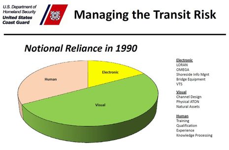
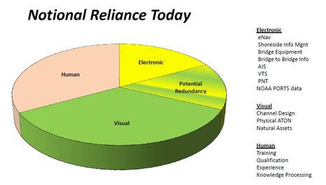
Then contemplate the section titled “NAV 2040”, which itself is a sign of how far into the future the Guard is trying to look. That’s where I got the two slides on this page, which sum up the case for reduced AtoNs pretty nicely, I think. “Notional” is a rarely seen word meaning mental or theoretical, but I think you’ll get the idea. Navigators don’t rely on visual aids to navigation as much as they did in 1990 because they have better electronic aids onboard and ashore. I not only buy that notion, but in fact I was feeling it on my trip south. I appreciated all the markers along the narrow stretches of the ICW but truthfully I didn’t pay nearly as close attention to them as I did decades ago, because I didn’t have to. Plus I was listening to all the chatter on talk radio about how many people are dependent on government handouts while looking at an ICW that’s hardly used by commercial vessels any more. So I asked myself, “Aren’t all us snowbird cruisers welfare queens too?” Seriously, do we really need all those expensive-to-maintain beacons, buoys, and lights?


More information I got from the April NAVSAC records is the cost of AtoNs in the U.S. (for 2009):
Direct Costs ATON Assets: $323M/YR
Support Costs for ATON Assets: $473M/YR
ATON Hardware $ 26M/YR
Grand total: $822M/YR
A country that spends $895 BILLION a year on so-called defense spending can certainly afford $822M/year for AtoNs.
I agree with bosunj 110%, and Ben this is probably the 1st time I disagree with you!
I believe there is ample evidence that a significant % of accidents and loss of life has been the result of sailors becoming “Electronically dependent” rather than relying on charts and the various related AtoNs. If you & the USCG have your way younger folks will eventually only know how to navigate via an iPhone, Samsung Galaxy, or iPad.
Accident free sailing, boating, cruising, etc, etc, etc is all about “Risk Management”. Today’s electronics can either assist to minimize that risk or if you rely on only it, increase risk!
Thus I might be forgiven for thinking your: “didn’t pay nearly as close attention to them as I did decades ago, because I didn’t have to” in reality is the very reason why we should maintain AtoNs and why you should have been doing exactly the opposite of what you did!
William, I think you’re confusing the human element in those pie charts with the electronics element, i.e. the operator and his or her tools. An unqualified boater can certainly misuse traditional nav techniques as easily as he or she can misuse electronics. All I’m saying is that the mix of tools has changed.
And, please, where did you get the idea that the USCG or myself is pushing boaters towards phone or pad navigation? Or that I rely only on electronics? Nope, I keep my head out of the boat fairly well. But it’s just a fact that most of us aren’t nearly as dependent on visual aids because our position is being constantly plotted on a digital chart.
I think there has been a misunderstanding … such is the “risk” when relying on a “electronic” rather than a “verbal” medium to communicate 😉
That said I do not agree with your statement: An unqualified boater can certainly misuse traditional nav techniques as easily as he or she can misuse electronics”.
IMO human impatience and need to “do everything faster” which is facilitated by digital electronics (e.g. who wants “dial-up” when “broad-band” internet access is available) increaases the likely misuse with electronics as opposed to even the unqualified boater having no choice but to invest time as well as assimilate information using traditional nav techniques.
I also was not suggesting that you and USCG are pushing boaters towards phone or pad navigation or to rely only on electronics.
All I’m saying is that the changed mix of tools which includes a gravitation towards electronics will be accelerated by not continuing to invest in the AtoNs, and consequently proportionately more accidents will occur because of this … based on the very nature of the human condition.
Whilst I agree with your: “But it’s just a fact”, that does not necessaarily mean “just a fact” equates to “better”.
Btw, I have 2 Rm E120Ws on board, as well as AIS, Radar, Interphase, etc. Still it’s my charts with their symbols, as what I actually observe that takes first priority. Speaking only for myself, I find my charts rarely if ever place my GPS position on land as a MFD chart can sometimes do. 😉
DGPS can go away. I do not have a receiver anymore. WAAS capability has for me replaced DGPS.
AS for ATONs this is difficult. It would require a case by case look at each buoy or structure. Even with GPS a buoy marking a reef is how I avoid the hazard.
Beyond the scope of this article, but worth a discussion is HF weather fax. Sirus is expensive and does not have the all products I use. The reliability of Sirus far exceeds WFAX.
Another agency is NOAA, I no longer use paper charts. I use an atlas for big picture chart discussions, but I no longer actually navigate using paper charts.
Patrick Harman
Oak Harbor, WA
Hello Ben,
Let me make sure that I am getting this right; The USCG is considering reducing the number of ground based differential stations that it manages. If this is correct, and strictly from the standpoint of many recreationsla boaters for whom I do most of my work, is it really a big deal given WAAS?
Correct me if I am wrong here by all means but it was always my understanding that WAAS was always more accurate than dGPS. This being the case, why continue to maintain a system that is less superior to one we already have that is more so?
Am I on the right page here?
George Schivley
A PRUDENT MARINER MUST NOT RELY SOLELY UPON
THE POSITION OR OPERATION OF FLOATING AIDS TO NAVIGATION, but should also utilize bearings from fixed
objects and aids to navigation on shore.
http://www.navcen.uscg.gov/pdf/lnms/D14__Special_Notice_to_Mariners_2012.pdf
If its a bad idea to use only AotNs, then surely its a worse idea to use only electronics as well as poor seamanship.
In the event of a collision or grounding who is going to have a better defense the mariner with a paper chart and log showing a record of their positions or the operator that states he was looking at his chartplotter?
Of course there is the distinct likelihood that an electronic AtoN will fail for any number of reasons the least of which are the increasing number of widespread power failures that require weeks to remedy.
I would trade a lot of physical aids to navigation for a centralized, gov sponsored central repository for all of the user generated content being generated. Especially depth soundings. Jupiter Inlet is a PITA with constantly changing depths – the only way to get this info on the chart is to have pleasure boaters take soundings that are auto uploaded to a central repository, and then downloaded to my chart plotter whenever its within cell range (via hotspot on my phone).
Paper charts are a waste of time, I don’t even have them on board. I have main plotter, and two phones each with their own GPS and different plotter software on them.
Based upon the demonstrated propensity of DHS leadership to favor expensive technology ‘solutions’ and a decided overall tendency toward ‘privatization’ perhaps this is merely an opening salvo to ‘condition’ mariners to accept a decision that has already been made.
One considers those operators who ‘no longer actually navigate using paper charts’ will perhaps also no longer use a hydrometer to assess the condition of their batteries and their battery’s individual cells? Does that operator even regularly wipe down the batteries and check their connections to ensure their electronics will have a better chance of working a greater percentage of the time? Does that operator keep a maintenance log to demonstrate such to the CG and the owner’s insurance company in the event of a collision or grounding?
Does that operator maintain a navigation log? In that log does that operator note passing an AtoN at such and such position and time? Does that operator note that an AtoN is out of position?
Does the electronics only mariner update their software? Update their charts? Update their Notices to Mariners? Do they even keep these publications aboard? Do they even subscribe? Are they even aware they exist?
Anecdotal evidence regards reliance upon electronics.
http://www.sailingmagazine.net/how-to/technique/964-dead-reckoning-
There is certainly a great deal of uses for virtual markers. I think the main discussion thus far is based upon an assumption that ALL PHYSICAL AtoN’s would be eliminated.
How many times have we encountered a physical marker but knowing that the danger is much larger than the actual marker? We have a harbor that has developed huge shoaling on a very quick basis. There is one marker, but the shoalling extends many hundreds of yards out from the beach and up the coast. Coming in the North end of the breakwater, especially at night and low tide is extremely dangerous, yet the ONE marker could be deceiving. This ia a perfect place for virtual markers to create a larger ring of markers on a chartplotter.
Another great use is sailboat races where you can create the marks without having to physically drop an anchor for the floats.
What about lobster and crab traps? How many times have we come into areas where there are large numbers of traps. A series of virtual markers could prevent running gear fouling!
I know these last two were not AtoN specific, but the technology can enhance, not detract, from traditional navigation and safety.
“One considers those operators who ‘no longer actually navigate using paper charts’ will perhaps also no longer use a hydrometer to assess the condition of their batteries and their battery’s individual cells?
[nope, I only use AGM batteries]
Does that operator even regularly wipe down the batteries [again, AGMs, so no fumes, no leaks, no corroded battery terminals… the problem has been solved]
DGPS – IMHO Yes, save the money. We cannot keep outdated technology forever. Considering eLoran (which I wanted to keep) is dead, I would expect DGPS doesn’t stand a chance. One consideration, does anyone use DGPS for timing signals ?? Hopefully no power line or telephone system devices use it to know the time accuratly.
Might WAAS go away in the future as well? I would point out that there are 2 entirely new constellations of GPS sats going up, and some GPS devices are coming onto the market that can read another in addition to the US version. Probably come up with a more accurate location than WAAS.
AtoN – IMHO No, keep them in place, but there may be opportunities to reduce costs by half or more. Perhaps they don’t need to be lit, have a working bell, horn, etc. If you let the noise and light devices fall into disrepair and have new markers simplified, a bunch of money can be saved.
I have personally experienced GPS failure, with all three devices I have showing the wrong position by 200 feet or more. I wouldn’t notice errors of 50 feet or less without physical marks to compare with. A 50 foot error is enough to hit sand or rock in my local harbor.
Looking way in the future, if eLoran came back, so we had a real backup to GPS or even massive sat failures, then maybe we can talk about retiring physical marks. Maybe we can all wear digital goggles that can show us where the marks should be and draw lines on the water, etc. like we see on foot ball or the America’s Cup. Stan Honey could help here.
Maybe with AIS, there is some way the coast guard can assist a boat in navigating with a dead charplotter and no knowledge of using map and compass.
It’s also of course fun rounding marks when we race sailboats. We often come within inches (or less) of an imposing obstical that could damage our boat. Oh the excitement when the current is drawing us into the mark or when more than one boat is rounding and attempting to get between me and the mark, jocking for position. A virtual bouy wouldn’t have the same excitement or risk of damaging the boats, and crossing situations with multiple boats coming to the rounding wouldn’t ssem workable without a physical mark.
My 10 cents
Interesting. I too have AGM batteries. I remove their cover and wipe them off as well as examine their connections and wiring. Yes, I own the best money can buy (6 Odyssey PC 2250s house and a PC 1200 starting) but that doesn’t mean I’m relieved of caring for them or from making certain they are in good order. There are many who don’t have AGMs however and many of those never maintain them. Those are the operators that I’m concerned with being on the same bit of ocean or waterway that I am.
My understanding is the correction signal from a ground based DGPS station is more accurate than that from a spaced based WAAS satellite, as long as you are in the vicinity of the DGPS station.
I boat in the Great Lakes which are extremely well covered by USCG DGPS signals, and I would like to have a DPGS receiver. Unfortunately there does not seem to be an affordable DGPS receiver available now. The technology to receive a 300-kHz radio signal and demodulate its digital data can’t be that expensive.
IMHO, get rid of DGPS now. The same argument was made before LORAN was cancelled. I haven’t heard boo since is was discontinued.
Regarding the ATONS, a lot more could be removed now before anyone would notice. Think about this: How many NavAids have been struck by boats because captains set them as a waypoint and instruct the AP to head there? Remove the AtoN and you can’t hit it anymore!
There used to may many many more lighthouses then there are now. Yet you don’t hear of boats running into hazards b/c the lighthouse is gone. The electronics have removed the need for them and this trend will continue.
Barry
USCG is one of the biggest users of Differential beacon system (think AtoN). There are other high precision users in the commercial arena that use this signal. WAAS enjoys high accuracy also but suffers from the line of sight issue with the geostat satellite, especially at high latitude. As Jim Hebert stated DGPS is more accurate, but the difference isn’t much. WAAS isn’t going anywhere, aviation is married to it and improving the infrastructure. In my humble opinion, augmentation of one form or another will be necessary; regardless the number of birds you put in space they all have to deal with the ionosphere.
Thanks, Jorge. I gather that line-of-sight to the few satellites which carry WAAS corrections can be a particular issue on the big vessels that tend to use DGPS, which why gCaptain may get a different response from their readership when they post about this (next week, I think).
Thanks also to Barry for a refreshing point of view. But a couple of notes for him and others:
* We might be hearing a lot about Loran if the eLoran system had been built out and reasonably priced GPS/eLoran receivers were available! If anyone knows of a true alternate electronic positioning system in the works, I’d like to hear about it.
* It’s pretty funny that bosunj’s “Anecdotal evidence regards reliance upon electronics ( http://goo.gl/d4Fhi )” involves the use of Loran C along the bumpy Maine coast in the mid 90’s. It was always known that Loran C suffered errors from nearby topopgraphy and so it was particularly unreliable around here. The dude could have at least had an inexpensive handheld GPS at that point in time, like most of the rest of us out in the fog.
* I’m still chuckling about the notion that keeping a manual log of positions and AtoN passing is somehow safer and more legitimate than using electronics. I would need a veritable boatload of navigators shouting out bearings and slapping down parallel rulers to even get close to the track logging that all sorts of MFDs, charting programs, and apps do on my vessel automatically. And if you’re running a boat by yourself — which is often what I do (even when friends and family are on board) — putting your head down to write something is time you’re not looking at what’s going on outside the boat.
Users typically think that DGPS corrections are used to improve the accuracy of their GPS receiver’s position calculations. The corrections also provide timely warning of faulty or inaccurate signals from a GPS constellation satellite. Yes, satellites can be set to transmit an “unhealty” status message, but it must be uploaded from a ground control station, which can only happen when the satellite is “in view,” which could take up to 12 hours.
Any system to provide GPS corrections and integrity monitoring requires a network of ground receivers, no matter how the data is transmitted to end users.
There are some systems using AIS base stations to transmit corrections.
Another thought about AtoN’s. Maybe because we don’t have fog often in Huntington, 90% or more of our sailboats don’t have fixed mount chartplotters. AIS is almost non existant.
First of all, I have to chuckle about the situation where one enormous part of the govt sets up an enormously expensive, but useful system, and then intentionally degrades its capability, to foil our enemies. And then ANOTHER part of the govt spends even more money to restore that capability, at a substantial (but lower) cost, because our citizenry (and the rest of the world, including our enemies) decides that the system in question is so valuable that it should NOT be degraded. Ahhh… isn’t democracy wonderful?
Concerning AtoNs, however, I do not see how the CG can make too large a shift to electronic AtoN, and pull up the buoys and markers. Yes, we have lots of people navigating electronically, and it is generally a better situation. The Mark 1 eyeball is a wonderful sensor, but it is still linked to the Mark 1 brain, and it is not able to see very well in the dark, or in fog, or in the fog of a confused Mark 1 brain. I can’t imagine anyone, except the US Navy, doing sea-and-anchor drills with people making plots on paper any more. I remember that in the old days, you actually needed 2 types of fixes to feel any sort of confidence about your position – one fix based on three gyro-compass bearings, and a separate fix based on three separate radar distance readings. Who has the manpower to do this now?
But, there are still lots of day-sailors and coastal sailors out there who don’t have or need AIS, who navigate in good weather with paper charts, and who use their eyes quite a bit, and they should not be abandoned. It is also re-assuring to those of us who have made the transition to electronic navigation to occasionally look up and see a real AtoN where we expect it to be.
Instead, the CG should spend the effort to put up AtoNs for entrances where the bouys change frequently, or on new wrecks or hazards, or to mark limits of navigation for special events or safety zones. Maybe, eventually, someone will figure out how to make money building and selling really cheap GPS/AIS chartplotters that are updated automatically with that latest data, so that everyone will be willing to buy one. But until then, we will have to keep the buoys and the fixed markers.
I’m a geek…I admit it. I love electronic toys and have a boat load of them (on my boat, of course). I freely and usually use my chartplotter, my hand-held GPS, and/or my GPS-enabled/chart-containing smart phone for routine navigation.
But, when the quarters get tight (in the ICW on Florida’s West Coast, where a ten foot mis-step puts one in walking territory), I depend strictly on physical AtoNs. My chartplotter, et al, frequently shows my boat walking around in 1′ water adjacent to the channel, even though the AtoNs and my depth instrument shows me in 8′ of water right in the channel.
I don’t use DGPS myself and thus cannot express any informed opinion about its retention, reduction, or elimination. But I use physical (including lighted!!) AtoNs constantly and would fervently argue against their removal for at least the next 30 or 40 years (that is, until after I’m dead and no longer use them).
Hi William, I disagree strongly with your notion that electronic navigation is somehow more prone to error than traditional navigation. But rather than argue directly about it, I found a relevant column I wrote back in 2002, called “Practical Navigators.” Here’s the first paragraph:
“The Navigator of the United States Navy does not mess around. Addressing a bow-tie-speckled crowd of New England yachtsmen and nautical history buffs, Rear Admiral Richard West passionately describes the ‘technological explosion’ that is blowing apart the grand traditions of marine navigation and affirms his commitment to an all-digital future. When asked the inevitable question about paper charts, he grins mischievously and says, ‘We’re going to throw them all overboard!'”
The article is here:
http://pmy.prod.aimstaging.com/node/146384
(and you need to click on “Practical Navigators Page 2” for the second half)
The wry and wise Patrick Harman got the email notice of my last comment and replied thusly:
“The armchair admirals tend to get under my skin. Paper charts are just plain a pain in the rear. I cruise between Olympia, WA to Seward, AK. the 500+ charts that cover this area would cause immense problems that actually would compromise my safety. The problems are:
1)Where to store them.
2)Keeping them up to date.
3)Finding the chart I need when I change destination.
4)They wear out and are expensive.
5)Navigation with paper charts only shows you where you were
I have several GPS’s on board & several distinct sets of electronic charts. To apply notice to mariners updates is as easy as down loading the charts.
In my opinion the prudent navigator only uses electronic moving map display systems. They actually show you where you’re at.
My ultimate backup is a complete set of place mats.”
I cruise in NW Europe, and I use my chartplotter exclusively for navigation. I carry a very large scale area chart, and 2 cruising guides – Reeds and a French book – that have detailed harbor charts. If I get zapped by lightning, I also have a 2 small GPSs (and 2 phones) that are lightning protected and can get me close enough to make out the bouys, and make it into harbor. So, that is another good reason to keep the AtoNs.
Regarding the USN, it is interesting that they have given up on manual plots, but I guess the cost of labor affects them too. The power plants I used to operate are supposed to be much more automated. I wonder what they have done with the large crews for CIC – maybe just gotten rid of them and replaced them with gamers. I just hope that the gamers can do physical damage control when the holes start to appear, the fires start to generate real smoke, and the water level rises at an alarming rate. There are times when a Mark 1 brain that is filled with fear can be very imaginative and useful.
Fixed marks aren’t going anywhere. Think of the number of boats that have no GPS, or no electronics at all. They cannot be abandoned by a responsible government.
However, there is great promise in eATONs for immediate warning of hazards to navigation, frequent variation in channels that previously required local knowledge, and more as yet unimagined applicationBuoyBouy Tenders are not going to be out of a job in the foreseeable future!
” It is also re-assuring to those of us who have made the transition to electronic navigation to occasionally look up and see a real AtoN where we expect it to be.” wrote rxc
That’s it exactly, that is my exclusive reason for wanting to keep AtoN’s. Everything else is an excuse or a bonus (bonus e.g. having them to race sailboats around)
One more thing I forgot to mention….
On more than one occassion I have encountered AtoN’s in the wrong locations from the charts! They do drag on occassion and sometimes are taken out of service.
Just because it is on paper, does not mean you still can rely, 100%, on the accuracy.
I will take my chartplotter and good lookout any day!
Virtual AtoN’s make me so frustrated. We need to nuke that idea from orbit. It’s fair to write a mark on a (electronic) chart, but an aid to navigation that virtual is just idiotic. Drawing a fake nav aid on a chart but not having something physically in the water for the mariner… makes no sense. I hated sitting in the standards meetings where virtual AtoNs were touted as a great thing.
Kurt,
You are not thinking like a true govt employee who is trying to cut costs and ensure safety at the same time. Virtual AtoNs have lots of side effects that support the mission, which is to ensure safe and effective navigation. First of all, updating charts is MUCH simpler when the AtoNs are virtual. Second, removing all the physical AtoNs cuts down on LOTS of maintenance costs. Then, with virtual AtoNs, you have essentially created “highways” on the water that have defined clearances that are well known to everyone with electronic charts. This means that everyone MUST follow the channels you lay out on the electronic charts. And they MUST have AIS, so that you can track them all the time, which has major safety implications. The security aspects are an additional benefit.
Now that you have everyone following the same “roads”, you can focus on the end points of the roads for infrastructure, and not have to worry about the empty spots away from the plotted roads. You don’t need to worry about the small harbors or inlets, etc. And you can also stop doing surveys of those areas. No one is supposed to go where you don’t have AtoNs plotted, so you don’t need to do any more govt-sponsored soundings outside the roads that are plotted electronically. Your major political masters, who worry about their major supporters (defense and large shipping and shipbuilding firms) are very happy because they can only use the new roads, and don’t care about the rest of the charts. You could probably stop billing the large users for a lot of work that you don’t need to do any more (don’t count on this one).
The small boaters can collect data about those places themselves and do their own crowd-sourced charting, if it is important to them. And the govt can sit on the sideline and gather in all that charting data for free, filter it as it wishes, at MUCH lower cost. In the interests of “safety”, you could get the politicians to pass laws that boaters sail outside the marked channels at their own risk, with no responsibility by govt to chart hazards any more.
I actually know of one inlet that has been treated just like this, on the Ches Bay north of Annapolis. Meredith Creek, just off of Whitehall Bay, looks like it is not navigable, according to the charts of the area. There appears to be a shoal of less than 1 ft at the mouth of the creek. So, the hoardes of Ches Bay cruisers that anchor in Whitehall Bay every weekend during the summer never even TRY to enter Meredith Creek. If you look at the Google-earth view of the creek, you can see that there IS a channel, and some exploration shows that it has at least 6 ft of water. Then, the rest of the creek is open to you with over 8 ft of water all the way past the building that houses the Ches Bay foundation (hmmmmm…..). VERY expensive houses, VERY expensive boats, and a VERY powerful organization that wants this creek to itself.
Electronic AtoNs have some very attractive benefits…..
Tools are as good as a manufacturer makes them. More tools are better than less tools. A fifty cent fuse can render all your electronic tools temporarily non-functional. I’m okay with seafood restaurant place mats if that’s all I have to use. It’s better than Magellan had and he went around the world in 1519, almost, at least his boat did. When all else fails make sure your Seatow policy is up to date.
Bill, you should have mentioned the video you just posted on your blog, to lighten us up a bit:
http://themarineinstallersrant.blogspot.ca/2012/12/experimenting-with-bob-navigator.html
An interesting story which could be related to this is cushion, I just read in a boating magazine. It was discussing how the entire eastern coast has changed, in some cases dramatically, because of hurricane Sandy. This was also the case following other major hurricanes.
The article went on to explain that many AtoN’s are gone or have move and that navigation may be very dangerous.
This relates because even if it was on a chart, doesn’t mean it is ere now!
It will take months until all AtoN’s are back in their correct place. The use of electronic AtoN’s could be operational in days, if not sooner!
All I got to say is “Go Air Force”. May the WAAS be with you.