
Garmin BlueChart Mobile, hands-on #1

As mentioned yesterday, there was significant news today regarding Garmin’s BlueChart Mobile app. In fact, anyone with a relatively current iPad, iPod Touch, or iPhone — that is, one that’s running iOS 6 or better — can download the basic and free BlueChart app right now. And I think you should because I suspect that the app has value even if you don’t go on to buy detailed charts ($30 for U.S. coastal) or the extra NEXRAD weather data (at just $4 it’s nearly a no-brainer). But I say “suspect” because when I tested BCM after the Lauderdale show, the loaner iPad3 was already fully loaded with charts and Premium Weather. But I sure saw a lot to like…
At first I’ll stay with the weather features, as Garmin’s own descriptions of BlueChart Mobile (BCM) seem overly modest about what they’ve packed into this app. Consider the Weather Stations menu, for instance. On the screen above you’re seeing all the stations that are reporting Wind Direction, and in the one below are all the stations that ouput a “Conditions” symbol. (While they’re obviously displayed along with Premium weather radar, do note its long and clearly demarcated animation.) However, it took me a while to figure out that weather buoys don’t output “conditions” for some reason and BCM can give you even more than a full buoy report…
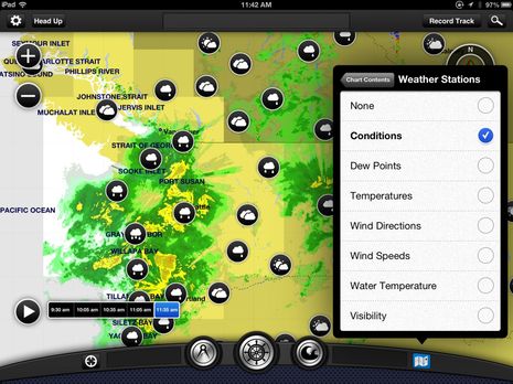
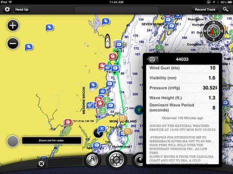
The screen below shows what I got by tapping on the Wind Direction icon for the weather buoy near my home on Penobscot Bay. Not only does BCM display all the near real-time buoy sensor readings but it tacks on the NOAA marine forecast for my section of coast. Now I’d like it even better if they used NOAA’s more fine-grained Bay forecast, but that’s a quibble and could be changed easily. And remember that BCM can also download and display GRIB wind files, as I saw during hurricane Sandy. That’s nearly all the major wx food groups in my view, all very easy to get at and with world wide coverage according to Garmin (please test that, readers, as I failed to when I could have)…
Before we leave the screen above, notice all the ActiveCaptain information icons. I think that BCM right out of the gate does as good a job of managing and displaying AC data as any other app, and that’s saying something. For instance, you can filter the icon categories you want to see — say Marinas and Hazards, but not Anchorages and Local Knowledge — easily using a near top level check menu…
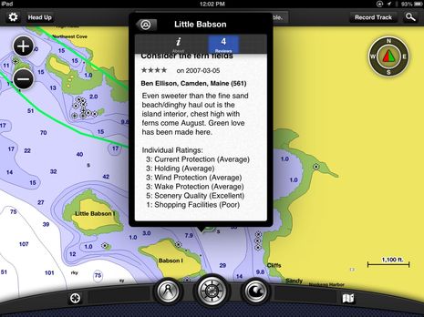
To illustrate the sort of AC ratings you’ll find in BCM, I’ve used a slightly risqué one I wrote back in early 2007 when AC was an infant. My, how far it’s come. During my trip I sometimes came across marinas that had more than 50 ratings, with the recent ones often just days fresh and containing details like fuel prices that weren’t even up to date on the marina’s web site. Add a whole bunch of new users, like a lot of Garmin owners with iThings, and the richer AC will get (you do have register on AC to get the data and you can add ratings right in the app)…

But I hope you’ve noticed in these screenshots how good the Garmin charts look, which is why — along with the weather data and AC — that I think BCM will also be popular with folks who don’t own Garmin hardware. One thing I noticed during the often complex 1,100 mile trip to South Carolina was how I would often turn to the Garmin 7212 when things got a little hairy navigation wise. Hat’s off to Garmin’s cartography department for emphasizing and clarifying what you really need to know. Not that Garmin charts are perfect. None are, which is why I’ve always advocated having more than one chart format on board.
Please also notice the “radial chart object menu” on the screen above. That’s what pops up when you touch a spot on the screen and it cleverly labels nearby objects and can also begin a route making session or take you to almanac data for that day at that spot…

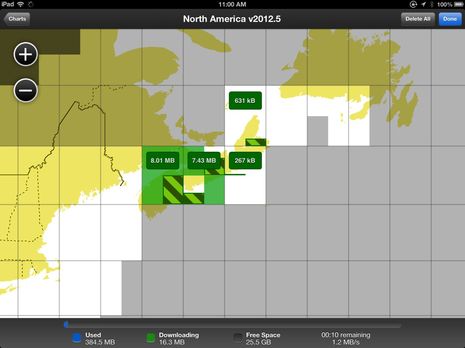
The various information windows above were all reached with just another tap on the radial menu. Nice! BCM’s chart management is similarly well designed. If you’re online and zoom into a new place the app will simply download the detailed charts (assuming you’ve made the in-app purchase). But if you want to make sure you have the charts you need when your iThing is offline you’ll get to the screen below, which let’s you select sections while telling you everything you need to know about file sizes, space available, etc. In this particular case I was trying to break it by tapping multiple sections, but BCM was unfazed. Also note my demo iPad had the full North American chart package ($50) and that there are other packages for much of the planet…
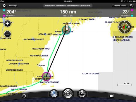
BCM also has a nice version of the distance/bearing tool seen in most charting apps, as shown below. But what I haven’t talked about yet is BCM’s route-making abilities and especially the Garmin WiFi Adapter that let’s the app share routes, tracks, and GPS with a Garmin MFD system. Look for that discussion here tomorrow but be warned that it’s not as happy news as what I’ve described so far. Then again, the WiFi thing could be viewed as just icing on the cake anyway. Meanwhile I’m hoping the Panbots with iOS 6 will download BCM, give it a try, and report back. Thanks!


Some folks over at BoaterEd and Tugnuts have already downloaded BCM and are discussing:
http://www.boatered.com/forum/topic.asp?TOPIC_ID=158319&
http://www.tugnuts.com/viewtopic.php?f=2&t=2956&start=30
After playing with the app for a while, it seems that there is one notable omission. The app does not work as an independent navigation device, that is, although you can enter waypoints and routes, you cannot navigate to a waypoint or navigate a route, only transfer them to your Garmin MFD. It thus appears to be missing the basic functionality of apps like iNavX. Am I missing something?
Good point, Marc, and I don’t think you missed anything. The reason I didn’t mention it, I guess, is that I’ve thought of BlueChart Mobile as a planning app since it was announced last February, and certainly Garmin has never promoted it as otherwise.
Also I don’t really think of any mobile app as a primary navigation tool on more than small boats with the possible exception of iNavX hooked up to a vessel’s sensor system. There are several others that will do decent go-to and route navigation — like iSailor, Memory-Map, Plan2Nav, and Navionics (with its new in-app-purchase nav module — but I tend to think of all as back-ups and/or most valuable for alternate cartography or other, often non-navigational, features. Then again, I’m wicked spoiled given all the MFDs and PC charting on Gizmo 😉
I downloaded it last night and have only now read your last comment Ben. If this is only a planning app then I’m a bit disappointed that I have to buy the same charts BlueCharts twice? Once for my Garmin MFD and again on the app?
I agree that navigation functions in apps like this are only a backup to your main navigation functions. But without them in the app there is no backup at all. If you already have an Ipad with a GPS built in, it seems that it only requires some relatively easy additional coding for the app to supply navigation information. The only apparent reason for the omission is that Garmin did not want this app to compete with its much more expensive hardware. It’s a marketing decision, and a poor one at that, sacrificing utility and the safety which backup navigation provides for a few extra dollars of perceived profit.
Well, anon, let’s clarify terms. Garmin BlueChart Mobile certainly can constantly plot your boat’s position on a full detail electronic chart using an iPad’s internal GPS (as seen in that last screen shot) or a high-precision Bluetooth GPS (I tried that too) or your boat’s fixed Garmin GPS if you install the WiFi Adapter (also tried). Isn’t that the essence of modern chart plotting and what you need for a backup?
Incidentally, I spent many years doing paper chart navigation — dead reckoning, celestial, bearings on known objects, transferring Loran A & C LOP’s and fixes to chart, set & drift calculations, praying, etc. — and I still didn’t know exactly where I was a lot of the time! Which is why I think that constant automatic plotting on a fairly precise digital chart is maybe 90% of plotter magic.
Moreover a boater can easily create a route in BCM and then drive along it. But what it won’t do that some other apps will is put up values like distance and bearing to the next waypoint. You’re right that Garmin could easily add functions like this to BCM (and with the WiFi connection it could add great stuff like realtime depth and wind info, though not as easily). But I think that there are reasons besides marketing that they haven’t. They’re serious about that new “Power of Simple” tag line, and it’s been working pretty well for them. They’re also quite safety conscious, as witnessed by the AIS alarms that you couldn’t turn off permanently (they relented eventually).
At any rate, I’m a glass-half-full guy and I think that BCM offers a lot of value. Garmin is certainly not the first to make its charts easily available on a mobile screen — in fact, it’s about the last — but the whole package with weather and AC seems pretty compelling.
And if I’d somehow seen what a $400 pad, a $100 GPS, and $34 worth of app could do 30 years ago: Holy _____, Batman!
Holy Batman Indeed. Along with all the things you said above the implementation of Active Captain is really sleek! This is a wonderful planning tool just to determine where to go. You didnt think Garmin was going to give you the whole chart plotter right on your IPad for that kind of money. This will be really useful on the Sally W.
PS It strikes me that a real backup navigation issue is what do you do if the GPS system itself failed? I believe that some programs like iNavX and Coastal Explorer can be used in DR mode, which could be a big help, but frankly I haven’t paid much attention to this issue.
Anyone want to survey plotters and programs to see what’s possible? For a little money, a hat, and Panbo fame? I’m serious! ben @ panbo.com
It needs to at least have a COG vector like the Navionics app (which also has weather, user generated content, etc. and runs on Android too).
Is there a night mode for viewing in low-light? IMO that’s one of Navionics’ major flaws. I would buy just for that.
That’s the point. If your GPS system fails, an Ipad with built-in GPS, and a program like iNavX, works as a great chart plotter. My main chartplotter is not working, hopefully to be replaced when Garmin comes out with new units this Spring, and I have used iNavX to go back and forth to the Bahamas a few times. It is the perfect backup. BCM, in its current state, does not fill that backup slot.
C Dan, I don’t think there’s a night mode but if you — unlike me with my sad old iPad1 — have an iThing running iOS 6 you can find out for yourself, for free: http://goo.gl/tQsHG
Say, I notice that the first two ‘reviews’ on iTunes mention the lack of a night mode, and I’ll add that Garmin has a good record of responding to user requests (and they do read Panbo).
I also learned from those reviews that you don’t get tide and current predictions in BCM without buying charts, which is not actually surprising. But I do think you can use the weather and ActiveCaptain features; can anyone confirm?
Does this app cache Active Captain stuff for use when there is no signal (e.g. Bahamas). Also, can I add AC info and reviews when there is no signal? This also works on Navonics, and I used it last year in the Bahamas to add info about anchorages.
Does it have a magnetic north compass option for routes or is it just true north courses?
Marc, what I meant was THE GPS satellite system, not a single nav system using it. I don’t think it’s ever failed on a widespread basis but there certainly have been local issues and there are real concerns that there still is no distinctly different backup electronic navigation system for the likes of us (which eLoran was supposed to be). Garmin is in the forefront with new marine receivers that also use GLONASS, but that’s not a total solution as the frequencies and delivery method are so similar.
svHaven, ActiveCaptain data is definitely cached. I think that’s true for all AC apps because they require it. In BCM you can also write reviews back to the AC database, which is not yet true for all AC apps.
I talked to a Garmin rep. re their blue chart mobile today. Beginning yesterday the navigation feature was added to the app.
But the rep did not have any info on how to interpret the colors shown on the radar and grid screens.
She told me that the plug-in wifi feature will not work with my 720 chart plotter (and presumably) with the 740. Bummer!
Darn, I wish I had an iThing that would run BCM, partly because I’m quite dubious that Garmin suddenly added “the navigation feature” to the app the day it was released. Sorry, Adrian, but I suspect there was some sort of miscommunication there.
As for the lack of compatability with the original 7X0 Series, Garmin should indicate that in the WiFi Adapter “Compatability” section. But they are quite specific in the same section about BlueChart Mobile. But it shouldn’t be too surprising as the 7X0 was never promoted as a network MFD except for the radar.
On the other hand, it’s also not surprising to see that the new EchoMap and 7X1 Series with built-in WiFi are “Compatable”…presumably without the WiFi adapter.
Android users feeling left out? You shouldn’t. The free Android app NutiChart has been out for about a year and a half with free charts, GPS tracking and Active Captain over the Internet. Off line charts are available by state for a fee and can display AC data offline. Way points but no routes. Weather overlay selectable for wind, pressure, temp, rain, wave height and meteograms for 7 days. Free over the net. Another free app, “Marine Weather” shows all weather stations and buoys and allows selection for their data feeds and radar. The new Weather Bug Elite app has location based lightning warning that will count down the timing of the storm to your location with updates. It also has location based scrollable current weather cameras which is a nice feature. The Garmin BCM is a nice addition to the ilineup of apps. Has Garmin said anything about about making it available for the one million new Android users that are coming on line every day? Looks like we will have to wait again until all the Apple folks work out the bugs! 🙂 Thanks all for the updates. Good stuff.
Ben asked, “I also learned from those reviews that you don’t get tide and current predictions in BCM without buying charts, which is not actually surprising. But I do think you can use the weather and ActiveCaptain features; can anyone confirm?”
From my experience today, you need to purchase charts to view wx info. Active captain Is available but w/o buying charts is almost useless….
Bill
John, I anticipated the Android question (and have a Nexus 7 that BCM could look great on, I think). Garmin’s answer: “We don’t have any immediate plans but we are most certainly not discounting the idea for the future.”
Thanks for checking on the weather, Bill. Guess I was hoping for too much.
To round the circle, I actually gave that Nexus 7 to my wife but today I realized that Android 4.2 supports multiple users (take that, iOS). So I just signed into my Google Play account and downloaded Marine Weather by BlueFin (I’m a fan, too, Capt. John). It looks great on 7-inch screen though the Nexrad weather radar does not really compare to BCM’s.
I think Garmin will be sorry if they wait. Some Android app wiz will reverse engineer BCM and have one on the market before them. Call it BlueSmart Mobile! People are already trying to figure out how to turn a $60.00 Pico into the $199.00 wireless adapter. Oh, wait! They have already done it.
The best Android radar is Weather Bug, I think. The Android version is better than the iVersion, and I do not know why that would be. At least it was as of several months ago. I bought the Elite today at the $1.99 introductory price. Says it will not be that for long. I used it all last summer on our cruise and did not miss the Garmin sat weather at all, but we are always in cell-ville. The alerts are good and the new storm tracker has to be worth at least two buck don’t ya think?
I don’t have Garmin onboard but downloaded BCM as a stand alone on my 4S.
Very much like the weather feature and radar.Good coverage over Vancouver Island.will check further north.
I like the variety of options..wave height is nice to show along with the radar showing the systems rolling in.
Could be a substitute for sat weather.
Mark has comprehensive run down of BCM features over at i-Marine Apps
http://i-marineapps.blogspot.com/2012/11/garmin-bluechart-mobile-trip-planning.html
Two questions…
#1 – I have just downloaded the iPhone version (1.0.2 in Settings/About) and it doesn’t appear as if there is a navigation feature; i.e. I can’t figure out how to Go To a waypoint…
#2 – Can anyone with the US Coastal or North America charts tell me if Canadian waters are included; particularly interested in areas north of Lake Ontario: Trent-Severn waterway, Rideau Canal and Ottawa River.
Thanks, Guy
Great discussion on the BCM. I think we are all trying to still figure out what it can and cannot do. I love the app but was a little let down that Garmin did not go all the way and provide full Go To navigation capabilities.
After seeing the quality of the app I would have been willing to pay serious money for a full featured app with all the bells and whistles. Maybe they will produce these add on capabilities for a price if we all scream loud enough.
I appreciated the link to my i-Marine Apps blog!
Mark
I have not been able to find a G.E. or SAT. overlay like the Navionics App has, a feature I really like. I hope they add this or that I’m just not finding it.
How can I get my routes and waypoints from my Garmin GPSMAP 5208 to my iPad BlueChart Mobile device using and SD memory card or e-mail.
Please tell me there is a better way than buying Garmin Marine Wi-Fi Adapter Kit $199.
I put all my routes and waypoints in my Garmin GPSMAP 5208 using and SD memory card I should be able to put those same routes and waypoints in my BlueChart Mobile device using the same SD memory card?
That’s a good point, Andy. I really like the way Navionics offers multiple sat photo overlays, even if they only work when the app is online. For instance, there’s no marine chart I’ve seen that shows the marina where Gizmo is now docked, as you can see on the USHarbors chart/photo combo here:
http://sc.usharbors.com/boat-listing/osprey-marina
Mark, I don’t thing there’s any way to move your routes to BCM without the WiFi connection, which is one reason I brought Garmin’s HomePort program, which is great for managing SD card info. But maybe Garmin will add support for iTunes file transfer, which is another nice thing the Bad Elf Pro GPS app can do. Garmin does respond to customer requests when they build up and they do read Panbo 😉
Just go and do it You will be happy. Yes the charts do go on the Trent Severn, Rideau, Chambley and NY State canals. Try buying the Canadian charts for that price.
I did find the Osprey Marina, I find the charts really good.Seems a lot of people who haven’t bought it are skeptical. Too bad. It is far easier to manage Active Captain on the Garmin App than on anything else.
Thanks, Allan. I agree that Garmin charts are very good, but it’s interesting that their own POI mark for Osprey Marina is off station and also misspelled! You’ll see what I mean on a screen I put up for the Hand’s On #2 entry:
https://panbo.com/assets_c/2012/11/Garmin_BCM_WiFi_adapter_connection_cPanbo-6531.html
Gizmo and about 80 other boats are not actually on dry land (which is why satellite photo overlays can be useful).
However, a nice feature of BCM I didn’t mention is that you can easily send in suggested corrections for stuff like that, which I already did for “Osprel Marina”. (Navionics Mobile has the same feature.) It will be interesting to see if Garmin’s marker location and spelling change in the near future. Incidentally, the AC marker, not shown on that screen, is correct on both counts.
I installed BCM on my new iPad and bought North America 2012.5. Nice charts, where they are. Too bad I’m shown on dry land. I could have saved a fortune on dinghy fuel if I realized all I had to do was step overboard and walk. (The charts inexplicably end about 5 nm NE of Rio Dulce, Guatemala; emininently navigable with about 500 boats here. I asked Garmin about it, they responded quickly by saying they don’t do rivers. Hmmm…) Navionics shows the shoreline detail dock-by-dock but has no depth soundings (nobody does, rats.)
“. (The charts inexplicably end about 5 nm NE of Rio Dulce, Guatemala; emininently navigable with about 500 boats here. I asked Garmin about it, they responded quickly by saying they don’t do rivers. Hmmm…) ”
check out garmin maps #SA0009R – Amazon River
Bill
Are you saying you are, “Up the creek without an app!”? I hate it when that happens.
The thing to remember is Garmin is not actually out there surveying the world. The are gathering up data from wherever the can get it. Probably not much data in Guatemala on rivers. Try the Erie canal right here in the USA not good data there also. Maps are ok just digital data not very accurate or geolocation as it is called. Won’t get better until someone actually goes there with GPS survey.
I was hoping to link the iThing with BCM to a 5212 via Bluetooth. I am guessing that the wireless devices IE;mouse for the 5200/7200 is through BT. Anyone try yet? I know they want their $199 for the wireless adapter but BT would be a much simpler solution.
The new garmin blue chart mobile app for the ipad which I love and just bought 3 months ago now wants me to pay for an upgradefor my charts – ugh!
I don’t mind annual map updates – they have to make a buck but 3 months?
Really!
Just made one unhappy customer. It’s only 22.99 but 3 months – wow.
Bought 2 maps between 2-6 weeks ago.
Now as some map updates are available I’m asking if there is a 90 day period (similiar to Nüvi) to get any map updates for free? iPad shows me I have to pay additional money.
This rabid Garmophile cries himself to sleep every night because BCM on Android appears to be an empty promise. Whoever decided to limit BCM to ios blocked Garmin from half it’s market. THAT strategy needs some explaining….
Got this free app before Christmas, and bought Ireland/Uk charts assuming it was only a planning tool, but was delighted to see that it apparently worked with the iPad II 3G models built in gps to provide real time vessel tracking on the chart with COG and SOG display.
Ok it won’t follow a route or go to a waypoint but you can actually use it to navigate a route by simply visually tracking along displayed route lines. Great app. One. Minor annoyance is the iPhone version seems only to have a COG display but not a SOG.
All the marketing info had suggested that it was a planning only tool, but this weekend we tested it extensively on Lough Derg and found it very accurate for position fixing and eminently useable for visual chart navigation. It seems to also support gps fixes wirelessly from an onboard Garmin network or external gps which should work for iPad WIFI only users (ie non cellulare models). Great app.
Tried out BCM today on my iPhone 4S (16gb). It worked well for about 20 mins then the screen slowly went dark. I could make out nav markers but everything else was really dark. Restarted iPhone, it worked great for about 15 minutes then same thing again. Any ideas what that might be? I thought maybe I ran out of memory. It’s really annoying.
Will the Garmin Blue Charts work with Active Captain on a Samsung tablet?
Garmin is adding some great features to BCM 2.0 this summer but it remains iOS (Apple) only. I asked about an Android version at the Miami show in February and Garmin would only say that they appreciate the Android platform and will try to respond to customer demands. In other words, speak up if you want Android BCM.
I do understand the reluctance, though; the percentage of tablets on boats that are Apple is much higher than in the larger population.
I find the weather radar a really great option even if you are only on land
We loved our BlueChart on iPad last year as we cruised from FL to NS and back.
Active Captain, great charts of US, Canada, and Caribbean to Colombia for $45? It’s a steal. The Canada Hydrographic Service charts alone would have been over $1,000… we got Canada BlueChart for $15 incremental on the iPad over what the US-only version is ($30).
This year as we cross to Europe we are buying almost the entire coast of Europe on BlueChart for $110. To put it in perspective, one single wide chart for our Garmin GPSmap 78s covering only the coast from Atlantic France, around Iberia. to the Franco-Italian border is $430.
Definitively a recommended product.
hi I just downloaded the garmin chart app for ipad and the water/ocean remains very dark and wont lighten so can read depths. Any ideas thanks
Have you purchased a chart region, Rich? They’re reasonably priced, I think, but they are not free.