
Navico GoFree Toolkit, developers invited!
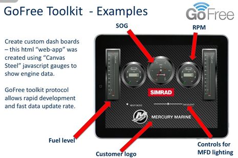
Now that we’ve had a look at Navico’s WiFi1 router and the 0183 Link, let’s examine the Toolkit that will purportedly give developers easy access to the higher level numeric data that’s running around a boat’s Simrad, Lowrance, or B&G systems. Of course that means NMEA 2000 info and it could lead to all sorts of interesting apps like that instrument screen prototype above. We’re talking about 38 data groups ranging from GPS to Bait Well to Inverter with 303 data types already defined by Navico. I’ll link to the list below and I think even non-programmers will get excited about what’s possible…
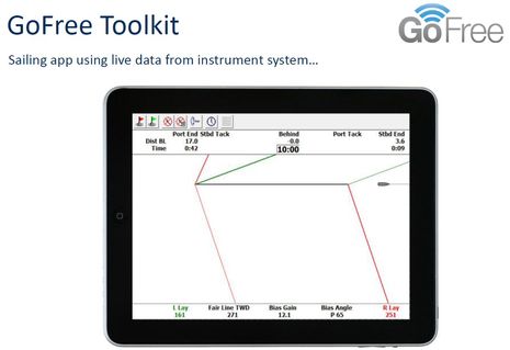
For instance, if you check out the GoFree Tier 2 spec downloadable here, you’ll see more than twenty Sailing Group data types as specific as Time-to-Layline and Boom Position that could lead to performance sailing apps that make the mock-up below look trivial…
But won’t developers have to purchase expensive NMEA 2000 documentation and possibly submit to some sort of NMEA approval process as we discussed (!) regarding the Chetco SeaSmart N2K gateway? Well, I’m happy to report that Chetco and NMEA have more than mended their differences and SeaSmart is evolving in great ways (like a free onshore server integration with onboard SeaSmart.net), but it almost seems like Navico is doing what Chetco couldn’t get away with, as suggested in the slide below:
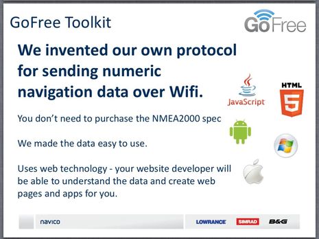
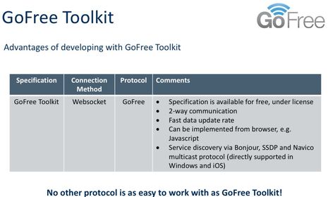
The significant difference — besides the fact that Navico has been a huge supporter of NMEA 2000 from its inception — is that GoFree is purportedly not a gateway because the data is being processed within an MFD rather than simply bridged from PGNs to Ethernet. The WiFi1 does not have an N2K port. Navico also tells me that it will be supporting NMEA’s OneNet Ethernet standard when it materializes (in “late 2014”) but at least in the meantime the GoFree team thinks it has come up with an excellent way to get the data out to the apps. Apparently a key element is the use of Websocket as the connection method. Now I don’t know beans about programming, but I’m hoping that some developers will download the Tier 2 spec I mentioned and tell us how easy the Toolkit will or won’t be to use…
So now’s the time to talk about the GoFree Tiers listed below, which have grown from three to five since first made public. It’s great to see that the CAN-bus data discussed above will be “Free & Open” but I believe there is an NDA (the “license” above) involved in getting the complete spec, at least for now. It’s also nice that some non-critical control functions — like the dimming slider seen in the top image — fall into this category, but it’s also understandable that an “agreement” (and possible certification program) is needed if an app gets involved with critical stuff.
The new MPEG4 Video Tier 3 refers to the mirroring of certain Navico MFD screens, as discussed in the comments to the previous GoFree entry, and like the higher tiers it involves a negotiation. Navico wants to get paid if an app essentially duplicates what its own hardware can do, but is encouraging apps that will expand the usefulness, and pleasure, of a boat’s Navico system. I don’t know what that will mean for the concept of “free range radar” but at least it’s encouraging to know that it’s possible for third party apps to access raw Navico sonar and radar, even from a system that doesn’t have the touch MFDs that support MPEG4 streaming. I do know that one of Navico’s hopes is superyacht applications that use most all these tiers, for free but thus getting Simrad gear on bigger vessels…
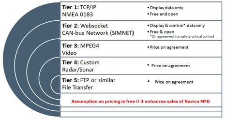
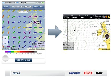
And finally there’s Tier 5, file transfer, and one example of that is a weather app that could also share GRIB data with a B&G Zeus capable of displaying it nicely. Is your head spinning with possibilities yet? Has a major marine electronics ever reached out to third party developers so aggressively? (And by the way, Navico would like your feedback on all this.) Will the other majors follow suit?
Maybe I’ll find out more at the Fort Lauderdale International Boatshow, which I fly to in the morning, having finally gotten Gizmo to her winter marina this afternoon (cutting it close ;-). One thing I learned in the last couple of intense Intracoastal Waterway days is that some of the apps Navico envisions have in fact already been developed for another system, Furuno’s NavNet TZTouch…and they’re cool. This MFD app concept is moving fast. More soon.


2-way communication, really? Apps can take data out, massage it, and put data back into the chart plotter via wi-fi, which can then show up on instrument displays on NMEA-2000?
The eye candy for sailors in the Tier2 Toolkit is beyond belief including Leeway, Current Set / Drift, Polar Speed, Polar Performance, Target Boat Speed, Target True Wind Angle, plus angles for various boat surfaces. This is a sailing app writers dream.
Then there is this, Activate / Deactivate / Acknowledge / Silence Alarm, which would suggest app writers can explore entirely new algorithms for smartly alarming on AIS target information.
Impressive
No comments ? Where is everyone ?? Wake up, this is exciting !!!
What Dan said.
At first blush this is exciting, and the T2 spec looks pretty good. An initial read-through suggests that Navico made good choices in terms of communication standards — WebSockets and JSON for data exchange. There isn’t much information about the structure of the various data fields, but that makes sense because JSON, unlike N2K (bleah) is self-documenting. In effect, the translations that Navico is making between the N2K data stream and their proprietary format documents the PGNs.
The irony, of course, is that this sort of thing is what we Ethernet loonies have been asking for for ages. Kees got frustrated waiting for it to happen and went ahead and built it himself; SeaSmart figured there was a market need and did the same. Now Navico. So we have at least three mutually incompatible ways of accessing N2K data via TCP. What’s next? Furuno’s implementation? Garmin’s? How many of these things will developers actually support?
It occurs to me that this might just be Navico’s attempt to offload app development to partners who will risk their own capital and engineering resources. I wonder if that will work.
I’m sure if I go back in the Panbo archives I can dig up the comments of some wag who predicted protocol fragmentation and market chaos, all because N2K was kept under wraps and NMEA waited (er, is waiting) until late 2014 (!) to do an official implementation of something that was — let’s be honest — a completely obvious need at least three years ago.
The wag’s been proven right.
In any case, good job Navico! Looks like fun to play with.
/afb
It would be nice to see support for AIS “Safety Related Messages” (I see no mention of this in the Tier 2 spec). Actually, the SRM usage seems pretty minimal, but the last time I was at sea a ship asked me if they could send me one to see if it worked (this was AIS message #12, but there are other related message types). I could read it, but couldn’t reply since I’ve just got a Class-B transponder.
Anyway, as much as I would prefer a single standard, it looks like Navico has put together a very nice concept.
We are still digesting all the ramifications of all this Dan. I agree that it is exciting, and possibly even a game changer.
this is terrifying. imaging all the yachties with nmea0813 & 2000 networks over wifi done on the cheap because it looked fun…. AIS Target? What AIS Target?….
I see no reason to be concerned, its all essentially read-only unless you have Simrads agreement,
Tier2 is very comprehensive, especially if we see what 2-way Tier 2 can do. Good play SImrad ( Navico)
Why Wi-Fi, instead of bluetooth? I would have thought bluetooth is a better fit with its specialization in short range, no worries of nearby boats blasting away with hi power amplifiers, no nonsense peer configuration, and very very low power.
Bluetooth would be fine for something like an autopilot remote, but the short range makes it a less good choice here. Putting the data on Ethernet means that it can be displayed or manipulated anywhere on the boat, even if the viewing device is tens of meters from the MFD (big boat). Or you could route the data over the Internet and view AC power, run, and switch indicators from the other side of the planet.
Also, virtually every computing device anywhere has some kind of an Ethernet connection (wired or wireless). Bluetooth is less common.
Software is out, so who designes me a dashboard for Ipad Mini like in the start of this topic?
According to Navico, GoFree Toolkit(n2k) will not be supported until RTM 3.0. This release supports GoFree App (mpeg4 streaming) only.
Yes, but it will take some time to develop a proper ipad app as well I guess
NMEA0183 is working also over wifi
Chartplotter Brand/Model:
Log/Wind/Depth Instruments Brand/Model:
NMEA-WiFi Bridge Brand/Model:
Additional Information:
iOS: 6.0.1
MID WiFi: 1.19E
NMEA0183 Data:
$SDMTW,,C*1A
$SDHDG,,,,,*70
$SDVLW,,N,,N,59.3,N,56.8,N*5E
$SDVHW,,T,,M,,N,,K*42
$WIMWD,,T,,M,,N,,M*5A
$WIMWV,,R,,N,V*34
$WIMWV,,T,,N,V*32
$IIXDR,C,,C,AIRTEMP,A,,D,HEEL,A,,D,TRIM,P,,B,BARO,A,,D,RUDDER*07
$SDHDG,,,,,*70
$SDHDG,,,,,*70
$SDHDG,,,,,*70
$SDHDG,,,,,*70
$SDHDG,,,,,*70
$SDHDG,,,,,*70
$SDHDG,,,,,*70
$SDHDG,,,,,*70
$SDHDG,,,,,*70
$GPGGA,,,,,,0,00,,,M,,M,,*66
$GPGLL,,,,,,V,N*64
$GPGSA,A,1,,,,,,,,,,,,,,,*1E
$GPVTG,,T,,M,,N,,K,N*2C
$GPZDA,,01,01,-13,-01,00*4B
$GPAAM,,,,N,*38
$GPAPB,,,,,,,,,,,,,,,N*26
$GPBOD,,T,,M,,*47
$GPRMB,,,,,,,,,,,,,,N*04
$GPXTE,,,,,N,N*5E
$SDDBT,,,,,,*45
$SDDPT,,0.0,*55
$SDMTW,,C*1A
$SDVLW,,N,,N,59.3,N,56.8,N*5E
$SDHDG,,,,,*70
$SDVHW,,T,,M,,N,,K*42
$WIMWD,,T,,M,,N,,M*5A
$WIMWV,,R,,N,V*34
$WIMWV,,T,,N,V*32
$IIXDR,C,,C,AIRTEMP,A,,D,HEEL,A,,D,TRIM,P,,B,BARO,A,,D,RUDDER*07
Verstuurd vanaf mijn iPad
Any idea where one can obtain the WiFi Tier 2 SDK instruction set? The link provided in the article requires a username and password to access the server to download the SDK.
Regards,
https://gofreemarine.com/developers/tier-2-sdk/
or direct link to pdf
https://s3-eu-west-1.amazonaws.com/navicodigitalassets/AMER/GoFree/GoFree+Tier+2+toolkit.pdf