
Class E AIS, will it be huge?
Back in March I wrote about the Small Vessel Cooperative Tracking project that the Department of Homeland Security (DHS) entered into the Small Business Innovation Research (SBIR) program. Essentially, a DHS department called the Port and Coastal Surveillance Improvement Project (PCSI) sought out an innovative way to persuade boaters to voluntarily submit their ID’s and locations so that various law enforcement agencies would have better situational awareness. Well, today I get to tell you about the idea that was awarded the SBIR phase two grant of about $500,000. We won’t see the results for many months yet, and there are more acronyms involved in thoroughly understanding the concept, but I think Class E AIS will eventually be a huge advance in boating safety and enjoyment…
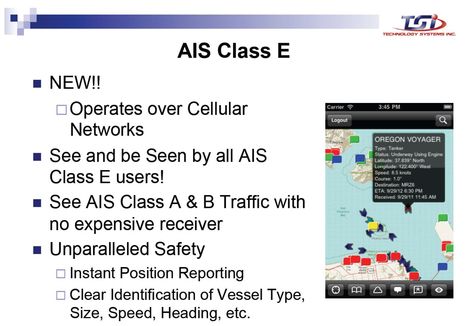
As the presentation slide above suggests — and Dan Corcoran guessed in a comment to that March entry — the consumer side of Class E AIS will be internet-connected smartphone and tablet apps. The prototype will be called Smart Chart AIS and it’s being developed by a Maine company called TSI (Technology Systems Inc). The idea is a free app so loaded with useful marine data like NOAA charts, weather, Class A/B/E AIS tracking, ActiveCaptain cruising POIs, and much more that boaters will gladly trade their tracks for it…
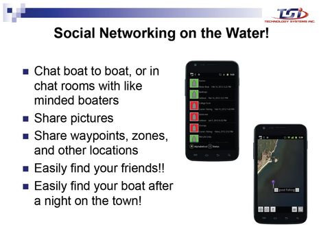
And the further idea is that such apps can become so popular that they can also support various forms of marine social networking, and thus become even more pervasive. If there’s a free and open national — perhaps even global (read on) — online database of unique boat ID’s based on the existing AIS format, then apps devices and the network effect could make things like boat-to-boat chatting and photo/route sharing easy and commonplace. In fact, there’s enough bandwidth in cellular Class E AIS that extra information like your home port and state registration or documentation number can also be included (plus more personal data like phone number and emergency contacts that will not necessarily be public but might be available to search and rescue authorities). There’s even room in the Class E data specs to identify both the individual operator of a boat and the boat itself…
By this point, some readers are probably getting uneasy about privacy issues but let’s remember that Class E AIS is completely voluntary; it’s all carrot and no stick. Nor does it interfere in any way with regular VHF-based Class A and B AIS because it’s segregated to the Internet, quite like the mAIS and Boat Beacon apps I’ve been testing this summer. Using Class E will not put your boat on the bridge of a ship unless the watchkeepers are using a Class E app themselves (though I’m realizing that some ship drivers, like my local pilots, are interested in any small craft info they can get).
Readers who develop marine apps without government help might also be uneasy, but they’ll be glad to hear about TSI’s underlying business model (remember that it’s working on an SBIR grant designed to foster small businesses). There will eventually be a software developer’s kit (SDK) so that any company or organization can interface with the Class E AIS data servers, as long as they deliver back the prerequisite user ID and track data. Any app — heck, any marine electronics system — could eventually be Class E enabled. That’s because if all goes well TSI’s future Class E revenue will come from tracks delivered to DHS, not from apps sales or advertising. Their real focus is the server side of Class E, and a peek at that reveals even more of interest…
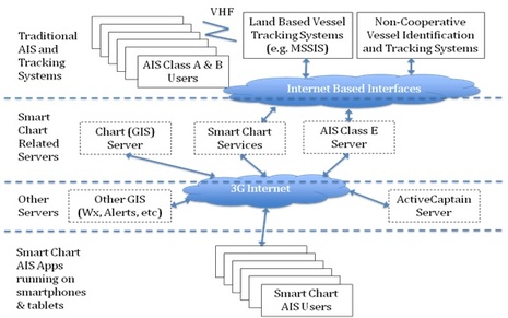
For instance, note that TSI is building its charting app on ArcGIS, which apparently is uncommon in marine mapping but quite common for government-level geospatial data (like all these NOAA ArcGIS layers). As I understand it, that means that overlays like, say, the exclusion zone the FAA setup for an antique plane aerobatic show I boated to recently (as part of the Penobscot Bay Rendezvous) could be easily pushed out to Smart Chart type apps. Similarly, oil spills or dredging operations, or who knows what overlay of interest, could be delivered from government agencies to boaters. Or delivered from private sources to certain boaters using a certain app, as long as the Class E server gets ID and tracking back. What service can you imagine?
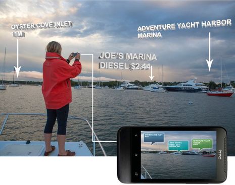
Meanwhile, a feature that might be unique to TSI’s own Smart Chart apps for quite a while will be augmented reality views of the data, as in the draft screen of ActiveCaptain info below. That’s because TSI has a long history with marine AR, which is how I came to meet founder Chuck Benton back in 2004. That’s when I wrote about TSI’s remarkable video-based LookSee navigation system, which did not quite make it in the yachting world but is apparently still in use aboard vessels with missions as challenging as the 88-foot LCAC (Landing Craft, Air Cushioned) mentioned in the article. And I’d like to add here that anyone who figures Class E AIS is some diabolical invention of The Government ought to meet Chuck. Among many other distinctions, this the guy who wrote Softporn Adventures on an Apple II in 1981, and thus is the father of Leisure Suit Larry in the Land of the Lounge Lizards! It would be hard to confuse Benton with a spook…
In fact, learning about Class E AIS over the last few months has been a reminder to me that The Government is actually a fairly chaotic mashup of agencies and individuals who rarely do anything with one mind. So while I think that the Class E AIS concept is a pretty brilliant way to provide the security folks with small vessel tracking — with boater benefits, and little taxpayer expense, to boot — not all those folks are necessarily into it. So, for instance, the government’s high quality Class A and B coastal AIS info will not be available to the Class E servers, at least not at first, and TSI will be using the public sources like AISHub and MarineTraffic that I’ve been contributing to (even more reason you should set up a station).
On the other hand, the technologists and problem solvers at DHS who got behind TSI’s SBIR idea are not shy about their enthusiasm. In fact, they presented Class E to a NATO symposium on Port and Regional Security in May, and I’m told that it was one of the most appreciated presentations. Hence my reference to global Class E above. And in September Chuck Benton and others will also present the Class E AIS concept at the RTCM Conference (which overlaps with the annual NMEA conference). The hope is that Class E will eventually become an RTCM-approved standard with the TSI Smart Chart AIS apps as the prototype. Isn’t all this a pretty huge deal, at least potentially?


I think the most compelling feature of a smartphone app would be a HELP or MOB function on the smartphone that would alert the closest voluntary boaters in the safety net that you are in distress, and point them to you. While there are other options to do this today, the vast majority of boats near me wouldn’t get the message because they simply don’t stay tuned into Channel 16 or have an MFD capable or wired to the VHF to receive an alert.
I can think of a few better “social networking on the water” ideas, written below as they might be used to appeal to boaters to join E-AIS.
– 1. Not quite an emergency, need some cheap help? Use our app to find a nearby friend to help you out of a small jam.
– 2. On the water lost and found: Broadcast to all nearby boaters your loss and get some help “Lost: white fender with red line in xyz harbor”, “Lost, favorite wooden oar, intials DW on handle”
– 3. Worried your passangers can’t use your VHF radio effectively in an emergency? Using your smartphone enable passangers to easily contact the coastguard with your position and distress, should you be injured or go overboard. (e.g. E-Rescue 21?)
– 3. You know you should be listening to VHF 16 all the time, but wife has been making you tune out Channel 16, eh? We have a solution, run our app to be alerted to tune into 16 for important VHF traffic, so your not oblivious when the USCG is asking for your help to locate a boater near you in distress.
Some thoughts, not rants.
What we have here is another of those interesting situations where boating accidents attributable to cellphone and tablet use are on the rise, and local jurisdictions are talking about “no texting while boating” campaigns at the same time the Feds are handing out money to for a tool that will increase boater distraction.
On the ICW this year we had to sound five blasts twice to get wandering boat operators to look up from their “i” whatevers. We could seem them looking at the devices as they headed toward us and toward a bridge abutment
It would seem the same save the parental-land benefit could be obtained less disruptively by making a turned on cellphone a boating safety equipment requirement.
DHS could then track the non-bad guys to their heart’s content (after getting an open-ended warrant with no probable cause other than we are boaters — think TSA applied to boating writ large).
Given the USCG increasingly shifts emergency traffic to a cellphone (at least between the Chesapeake and the Bahamas) it could also save lives.
We carry a transponding AIS and have it on except in marinas. Already the target information is becoming overwhelming in major ports and harbors. I certainly hope we will be able to filter out the “E” crowd from the displays. Otherwise I think we will have diminished the value of AIS overall.
Christopher, please acknowledge that there is no way for Class E AIS data to get on your regular AIS display unless you want it to be there, and even then I’m not sure when or if it will become a possibility. Class E uses a totally different communications protocol than Class A and B. They are completely segregated except for online viewers and apps that bring the data streams together, which no one has to use.
Also, I’m confident that the solution to “overwhelming” AIS targets is simply smarter displays. There’s no good reason that non-dangerous AIS targets have to plotted as big triangles on your screen. They can filtered down to little dots or off screen altogether until they become dangerous (because smart filtering doesn’t mean the device or software stops tracking targets).
Ben, fair enough. Now, how do we do this to keep boaters focused on the boats around them rather than the distracting devices. I realize the social component is the hook to get folks to voluntarily disclose location, but what’s available today is already problematic on the water.
As to the display issue.
We have a Vespermarine unit in the nav station. It’s excellent. We port the data to a cockpit laptop. In both nav software packages, the display modality is big ship derivative. Give me a big bridge, proper lighting, a 19+ inch display and a trackball and I’m fine with it. With a cockpit seat, sun, shade, moon, no moon, an 11 inch display and a mouse or a trackpad…not so much.
What I have been discussing with providers is a hot, warm, cool target concept which would allow us to toggle between dangerous/potentially so/other/all states with a repeated key stroke/button push.
Feature rich menus to set up the states are fine; we don’t want to have to routinely address multi layered menus when sailing in a stiff breeze and substantial swell across Tybee Roads at midnight.
Well, wouldn’t Vesper Marine’s neat ability to set up four different and deeply configurable AIS alarming profiles be nice in a charting program or MFD? In other words, you get to save your preferred alarming modes and then use different setups in different conditions without further mucking about.
As for distractions, I don’t buy that they are a particular problem of apps or the MFDs that used to be the brunt of such worries. Almost every time I’ve been underway in close quarters this season I’ve noticed people who are also underway but haven’t yet noticed me. It didn’t seem like they were distracted by screens at all, but rather by the beauty and boatiness of Camden Harbor or Rockland Harbor or similar. Should we uglify ourselves for their safety?
PS: Dan, some neat ideas there. Thanks.
It would be good to be able to port the profiles. I’ve also talked with them about a 100% emulator for their chart referenced display. Unfortunately, the price point would be a significant percentage of another AIS.
As to the satire, a Coast Guard team killed an eight year old boy in San Diego Harbor (also quite pretty) while using cellphones. In Charleston, (parts of which are pretty) six people were injured by a USCG boat, the crew of which were using cellphones. The DUWK boat accident on the Delaware River (not so pretty) was directly and criminally attributed to cellphone distraction.
The NTSB has directed the Coast Guard to clamp down on cellphone use pending their final determination of causality.
If this is going on with experienced, licensed mariners, one might be safe in assuming it’s going on with the recreational boater. Since we have seen it, for us, it’s out of the realm of assumption.
USCG stats? — more than 1 in 4 the accidents on the water are attributed to operator inattention.
Time for me to go do something useful.
I’m going live on ProBoat Radio in a few minutes. You can call in questions and we will talk about Class E AIS among other things.
http://proboatradio.com/past-shows/
I agree…too many toys/apps now…And navigating with any device that is not sunlight readable is asking for trouble on a boat. I have an ipad with charts and I use it down below.That’s where it stays.
In the land of AIS, Sweden (Håkan Lans, the inventor of AIS lives here) we alredy have a similar app – SeaPilot.
http://www.stockholmradio.se/seapilot
“Seapilot based on professional shipping standard for electronic navigation and is a simple, unique and professional navigation system for iPad and iPhone.
Seapilot is adequate navigation aids, but at a fraction of the cost compared to a plotter. It is the first navigation app ever with AIS data, which among other things makes it possible to see all the vessels with AIS transponder. A technology that in addition to increasing safety at sea also provides the opportunity for what we call “social Boating,” a way to be seen and stay connected on the lake.
Also presented weather in real time via AIS from over 60 weather stations in Sweden. Seapilot shows wind speed, wind direction, air pressure, temperature and water level, etc. from any weather station.”
It’s not AIS Class E, but implements alot of the functions described by TSI.
Btw, i’m not in any way connected to this company.
You all should listen to the ProBoat interview, its still available, Ben has a great radio presence and spoke more deeply about this topic:
http://proboatradio.com/past-shows/
I caught the end of Ben’s ProBoat Radio interview where I posed a question about potential use of smartphone applications in assisting captains in communicating, via Chat, their intentions in passing situations and was partially surprised to learn that its not a reasonable expectation that these phone apps will have positional data good enough for collision avoidance. Listen at the link below to learn more about what you can expect, what the benefits are more likely to be, what is being done so favorite boat applications can use this data, and approximate dates when most of us can first use this stuff:
http://proboatradio.com/past-shows/
Thanks, Dan! To clarify, I think smart phones and pads can deliver pretty darn accurate position, COG, and SOG, and the update rate in Class E can be as good or better than Class A if desired. But the whole system is dependent on cellular data service and remote servers, plus volunteer shore stations for the Class A and B info which is only one-way (receive) in the Class E world. That all leads me to be very cautious about Class E as a collision avoidance tool.
Perhaps some day we could add a BlueTooth enabled portable transducer with suitable mount and collect depth data to send to some charting entity?
I use an an iphone mount that adds a GPS and power for the phone. Improves position updates and location accuracy.
A mount that feeds the iPhone position data from the vessel GPS system would also improve the position accuracy. Or via Bluetooth.
Interesting concept but it does not have the reliability of AIS. The beauty of a VHF-based system is that it always works — I can see an AIS equipped vessel in the wilds of South East Alaska as easily as I can see one in Seattle. Cell phone internet access? Not so much (even on the Seattle waterfront.)
Why is this important? If a boater choses to forgo class A or B AIS for this method and if they chose to forego radar, then they are completely at the mercy of the cellphone network when they are in the fog. They may have a false sense of confidence that will lead them to go forth when they shouldn’t. It is like a climber roping up with a safety rope that might not carry his weight — worse than no rope at all.
This is not a theoretical issue. I can tell when my boat (with an 8′ powered antenna) loses the internet because a small gizmo pops up on the tool bar. I lose the internet in the San Juan islands just as I come out of Thatcher pass, which is right where you begin to cross the shipping lanes. Cell phone access has been getting vastly better over the years, but I doubt that there will ever be a tower in the middle of the Strait of Georgia (for example.)
Perhaps in other parts of the country cell phone access is as reliable as VHF, but in my experience it is not so when on the water — especially in the shipping lanes which tend to be fairly distant from cell towers.
AIS over cellular is working pretty well for this long slog south. I just put phone in its boat holder, attached the charge cable, opened mAIS, and we’ve been tracked for benefit of friends and family everywhere we’ve had a connection. Check out current position and itineraries here:
http://goo.gl/nLxNe
The tracks are also a map of coastal cell coverage, or at least Verizon’s, as mAIS tries to send a position every 10 minutes.
We just exited Buzzard’s Bay headed for western Long Island Sound. Another night out, but best to catch the weather when it’s right!
What happened to this idea?