
NV Charts, the paper & digital sweet spot?
When I wrote about NV Charts after the 2011 Miami Show, I appreciated their unique approach to recreational charts. For one thing, they make their own (though based on official sources), and for another they won’t sell digital versions without the paper version (or vice versa, your choice!). But now that I’ve had some hand’s on time with the actual products, I’m even more appreciative. These are beautifully made charts no matter which way you look at them…
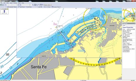
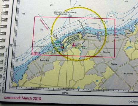
One paper/digital sample I have is NV’s 10.2 Cuba Northwest kit and you can see the electronic version of the Marina Hemingway area showing above (in Coastal Explorer Light which comes free on the CD) and in handy-size booklet form below. One obvious advantage of the digital charts — which can be viewed in numerous charting programs now — is that the different scales can be quilted, so you don’t need to flip booklet pages to get the one you need. You can install the charts on two computers, by the way, and I found the registration process completely painless. But before I mention special features of the print versions, let’s check out the nice the common attributes of NV cartography…
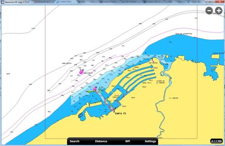
The only Cuba charts I have for comparison are the Navionics Gold portfolio I got in PC form using the coupon that came with a Platinum+ chart card (as discussed here). They don’t seem to have nearly the detail the NV charts have and of course vector presentations always pale compared to raster charts in terms of fonts, item placement, etc because the cartographer has so much more control over the rasters. But this seems particularly true with NV-Charts as the cartographers seem so artful. Also in the area below Navionics apparently missed a middle scale chart as source material, which is why the NV has more complete coastal soundings outside the harbor scale chart.
If anyone has C-Map, Garmin or other versions of this area please send an image for further comparison. The quality of Cuba charts may get more important if it does become easier to cruise there from the U.S., as my friend Bruce Kessler and others are working on…
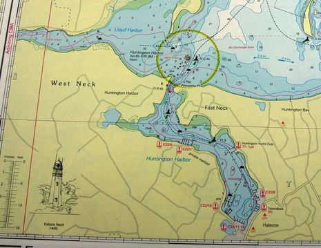
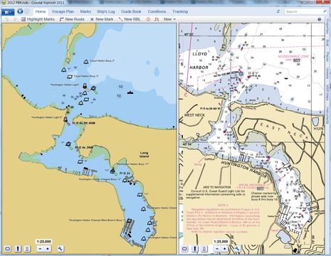
On the Long Island, New York, paper NV-Chart below you’ll see a neat detail that doesn’t make the digital editions, which is that sketched profile of a prominent light house. I’ve only seen these on older British charts, but NV went to the trouble of creating them even for U.S. charts like this. The larger scale pages of this 3.2 Long Island kit seems to have sketchs of every major light on the Sound, and the Cuba charts also include landfall profiles (another Brit nicety). They are more evidence that the NV folks revere chart making, I think…
Remember that NV’s U.S. paper (and digital) charts are not simply reprints of NOAA rasters (also known as RNCs). While they are apparently created using NOAA vector charts (ENCs) as a base, look how different they are from the straight-up NOAA ENC and RNC samples seen below. NV also includes a plastic cover for the chart booklets and a “Harbor & Anchorage Pilot” keyed to print chart icons like those red marina marks above. And aside from out of the way places like Maine (hurrumph!) you can now cruise the whole East Coast and Caribbean on NV. Has anyone had more experience with these charts and found pluses or minuses I’ve missed so far?


I have used these since 2006 when I spent my first money on charts after buying the boat and I am pretty happy with them, though I haven’t used the US charts yet.
A big plus is that they work well with Coastal Explorer.
I have read that Swedish lifeboat crews use NV charts for their home waters, preferring them over those made by the Swedish HO. The saying is that the reason for the excellent quality in this area is that the owner, Hasko Scheidt, likes to go there on his summer trip.
At least for the German charts, when installing and licensing the digital version, you are automatically registered for a set of monthly corrections (for the summer months which most of us are interested in). This consists of a colored PDF file which you can print and then cut and glue to the paper charts as well as update files for the digital charts. You get these as a download link in a text-email. I was surprised by the amount of corrections in these and some of them have been highly relevant.
This week I found that a download link for the update was broken and a simple email to support yielded a corrected link within 30 minutes.
Not everything NV is good, though, as they also sell re-rasterized digital Imray charts under their own brand name which are poor, as steverow has pointed out, and having had only a brief look, I can only agree.
The “paper & digital” applies only to the charts that they make themselves. So I would tend to recommend any of their products, sight unseen, that comes in paper & digital but be careful about anything available in digital only or paper only.
Registration can be made to a dongle to be able to use the charts on many computers but I have often left the dongle in the fixed-mounted USB hub on the boat and then couldn’t read the charts at home or when traveling so I have switched back to PC-registration with this year’s set of charts. I was told that they would allow the dual registrations to be to a PC and to a dongle which may be a good compromise.
We plan to visit the US east coast in 2014 and I hope to be able to afford these charts.
I’ve used their Bahamas charts which they took over from Maptech. I’ve had to send NV info about a reef they missed that was shown on the Maptech charts. Anyway, its a bit unnerving. I found the use of old (very old)DMA charts by Maptech right since the Bahamas was essentially a series of military bases during WWII. While Explorer charts are the defacto for the Bahamas, they also missed this particular reef.
I chalk it up to its simply hard to track all the info thats available. NV charts are as you say very pretty.
Don
NV is a known and popular chart maker in Germany. Therefore, I’ve used many of their charts over the past years and like them. Their chart kits (paper+digital) for specific regions offer pretty good value. I’ve used the digital version of the charts on the Mac and iPad, while the paper is on the chart table (Baltic, Baleares).
But boy was I disappointed when the MED 03 and MED 04 chart kits I purchased earlier this year wouldn’t install on either Mac or iPad. They are not very talky on the matter but I presume this is because they get these charts from their french partner Navicarte and somehow they are different. They do install on PCs though. I used to think these times were over (PC yes, Mac not), but here you have to be careful and check which of the chart kits works on Mac&iOS before purchase!
You can also download NV Digital charts from within compatible software on Windows, Mac OS X, and iPhone / iPad.
If you buy the paper based NV Digital charts, the product ID on the disk may entitle you to a free download version of that chart, depending on the chart region — only the $10 X-Traverse data plan is required to get at the download of eligible NV charts. See https://www.x-traverse.com/nvactivation
The NV charts are stored on a secure X-Traverse account. Then your software, such as Fugawi Marine ENC 4.5 for Windows or MacENC for Mac OS X, downloads the charts from the account. After downloading, the charts stay on the hard drive, no further connection required.
110 people have now been infected with cholera in Cuba. URL didn’t work for me.
I looked into this when we went to the Bahamas for the first time, and bought the NV charts for the Bahamas, the DR, Turks and Caicos, and Puerto Rico/BVI. In the Bahamas (the acid test — shifting sands)they were as accurate as any others I saw, and I’m sold.
It is a major plus that they sell both paper and digital together.
When we go to Europe, I’l lbuy their charts for coastal regions wherever available.
In response to the comment about using NV charts on the iPad: they do work with Memory-Map on both iOS and Android devices. You import the charts into Memory-Map on the PC, then copy some files to your phone or tablet. This process works with all BSB-based digital charts.
Speaking of Cuba, my old buddy and new colleague Peter Swanson made a strong case for why the rules stopping cruisers from going there should finally be dropped:
http://blog.soundingsonline.com/2013/01/16/end-the-embargo/
Note also that NV Charts are now available for Navico plotters:
https://panbo.com/archives/2013/01/nv-charts_on_navico_displays_another_paper_option.html
Bummer! The CUBAR rally to Cuba was denied permission by the Obama administration. Peter Swanson has the story:
http://blog.soundingsonline.com/2013/04/17/feds-shoot-down-cubar-rally/
NV-Charts now has charting apps for IOS, Android, and Windows 7/8. I think they are free if you already own a current ‘chartkit’ edition, but many of the details are in German:
http://www.nvcharts.com/app/
I’ll help with the German part…
from the newsletter:
Getting started:
– download and install the file from the store (App Store, Google Play, Windows 7/8, amazon appstore)
– under charts, click add charts and enter the serial numbers [I think this means ‘of any NV charts you own’]
– under ‘update’ you can download your charts and keep them current
From the app description in Google Play:
nv charts App · Features:
– reads all NV. charts [must mean ‘those in nv.digital format supplied as part of chart kits’]
– simple download of charts
– most current data at all times
– seamless quilting
– free zoom and pan
– position via GPS or via radio tower [must mean ‘GSM-based location services’ – I don’t think I want to navigate via the latter]
– intuitive route planning
– track recording, marks, bearing-to-target [don’t know the meaning of ‘marks’]
– marina information
– NV. Pedia [www.nv-pedia.de]
– sketches of lighthouse towers
– instrument display
Thanks, Henning! But I’m pretty sure that the apps only work with some editions of existing NV-Chart CD’s. In one place it seems to say only 2013 editions but there’s also a list on the blog that seems to indicate that some older editions will also work.
The app will work with these charts:
USA:
Region1_1 2012
Region 2_1 2012
Region3_1 2011
REGION3_2 2010
Region4_1 2012
Region5_1 2012
Region5_2 2012
Region6_1 2012
Region6_2 2012
Region8_1 2012
Region8_2 2012
Bahamas:
REGION9_1 2011
Region9_2 2013
Region9_3 2012
Caribbean:
Region10_1 2010
Region10_2 2010
Region12_1 2013
REGION12_2 2011
REGION12_3 2011
Region16_1 2012
As far as I can see, the above list shows the *current edition* of each NV chart in these areas.
Also all of the Europe charts (e.g., series 1, 2, 3, 4, 5, inland waters) are marked “- with App charts direct download!” on the webshop.
So I guess the general rule is that the app works with the current edition of any nv.digital chart sold as part of a pack.
With the app being free, this is excellent value for anyone already owning a (current) NV chart pack.
It may make sense for those using the app as the only means of electronic navigation but also needing a full current set of paper charts.
It is priced out of the market for anyone just looking for a navigation app to play with a little.
For those seeking an app only version, we are running a campaign:
$10 for every US East Coast set.
http://us.nvcharts.com/index.php?page=categorie&cat=30
You can download the app here: http://nvcharts.com/app
With best regards
nv charts, app development