
Crowdsourced soundings on the ICW, CruisersNet & more
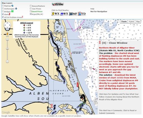
As a guy who may actually cruise the Intercoastal Waterway this fall (as opposed to last year, when I only talked about it!), I’m delighted that there’s so much competition to collect and share relevant information about it. A particularly notable development is the way CruisersNet.net has teamed with Survice Engineering and EarthNC to overlay the former’s “Argus” volunteer-collected and tide-corrected depth data onto the latter’s slick online charting engine, along with lots of other valuable CruiserNet info. The screenshot above shows hundreds of recent ICW soundings less than 12 feet, and also a professionally researched “Problem Area” note, and of course you can drill down to much greater detail…
You can start with CruisersNet’s Argus layer guide or you can just open the online charts and check the box to enable the Argus layer. You may well want to unclick some other layers for clarity, but at least on my Internet connection changing layers, panning, and zooming are all quite snappy. What you’ll see is some current ICW depth detail that could be darn useful for visualizing the issues ahead, especially as it’s color coded. I think it would be nice if soundings over 12 feet also showed, just so we’d know where the data collecting boat(s) had seen that much depth, but apparently Google Maps can only handle so many data points and limiting them to “<12 ft” was the solution. And this is likely just the beginning of crowd sourced soundings…

Also seen on the screen above is some anchorage info that might be helpful to someone who didn’t want to overnight at the Coinjock marinas just north of this spot. These are not shown on ActiveCaptain, which may well be because CruiserNet is edited by Claiborne Young, who used to write print guides to the ICW and is now enthusiastically trying to provide the same thorough coverage online and with reader assistance. As wonderful as pure crowd sourcing can be, I’ve always thought that there was still room for pros, as discussed here…

But that’s not to say that ActiveCaptain didn’t do a fine job of covering the same shoaling around ICW Mile 54 (which I chose as an entry example pretty randomly). As you can see in the screen above, the area has been noted with an orange Hazard marker for some time, and has been very recently updated in the marker’s Comments section. While it doesn’t have the same graphic detail as the Argus overlay, it works, and if AC ever decides to support user-generated sounding files, it will no doubt do a bang up job.
ActiveCaptain data is also available via all sorts of phone, pad, and PC apps — with the fully two-way Garmin BlueChart Mobile coming soon — while CruisersNet is still pretty much online via browser only. The exception is the EarthNC iOS app, which can show CruisersNet Alerts and Problem Areas — as well as some MarinaLife and Waterway Guide data — but not the Argus overlay (yet)…

On top of all that, there’s going to be more crowd sourced depth data coming. If you poke around the Argus “Solutions Set” page, you’ll see how much info an active boater like, say, a Sea Tow operator can collect for a tricky area like Barnegat Bay (which I’d love to gunkhole). And while there’s another depth collection operation going on that I can’t write about, I can report that the mighty Navionics is getting into the game…

At the Miami Show in February, Navionics announced UGC 3D, which is essentially a plan to incorporate user-generated sounder files into the Community Layer of Navionics charts, which is now even getting to chart plotters. The red lines on the PowerPoint screen above apparently show the track of collecting vessel whose data will be coming soon to that wickedly complex Chatham, MA, chart area. In the May/June issue of PassageMaker, unfortunately not online, Navionics project manager Shaun Ruge is quoted thusly: “Soon users will be able to record sonar and send it to Navionics. Then, in a short time (the goal is 24 hours), we can give a Freshest Data download that has an updated chart layer containing the recent sonar alteration.” It’s going to be very interesting to see how that works in practise!
While I was at it, I checked out the current Navionics data for the sample section of the ICW and was pleasantly surprised to find that it was reporting a more realistic dredged area of 5 feet instead of the normally cited 12 feet, but you wouldn’t know it unless you click on it. Navionics UGC also has anchorage info similar to what CruisersNet lists, in fact almost exactly the same. I don’t know how that happened but I do know that a lot of energetic companies are competing for our attention with cruising data, which seems like a good thing. Have you used these resources, or others a prospective snow bird like me should know about?


Incidentally, the ActiveCaptain screen above shows one of the new starred marina icons that are part of the sponsorship program they’ve devised in part to avoid the clutter of banner ads:
https://activecaptain.com/sponsors/programs.php
Note that CrusiersNet.net has lots of banner ads that don’t show in my screen shots. But I think both types of revenue generation can work, and I certainly hope they do. In fact, when I’m actively using these sites I intend to show a little love to the businesses that support them. (And of course I appreciate how you all pay attention to Panbo’s advertisers!)
What are the biggest challenges being faced in communicating this new information on 2D maps / what are the leading ideas to identify soundings that are recent/crowd sourced vs. decades old?
Will there be some reconciliation of a rock symbol with a sounding of 12 ft depth? E.g. can rocks and wrecks ever be removed from our existing maps?
Neat! Mark and Diane Doyle of On The Water ChartGuides also seem to be collecting soundings as they work north on the ICW. They’ve posted a taste on their Facebook page: on.fb.me/LB1xn0
Dan, there are many challenges to sharing, validating, and presenting user generated soundings data, and I think that we’ll see them shake out. The Doyles are apparently using a facility built into Coastal Explorer, though I wish the screenshots were bigger.
More is revealed about Navionics crowd sourced soundings by my colleauge Chris Woodward on her Sportfishing magazine blog:
http://www.sportfishingmag.com/blogs/next-cast/hit-refresh-button-your-sonar-navionics-user-generated-content
What I hadn’t understood but makes great sense is that the UGC soundings will go to the “fishing” layer and not to the regular chart layer. In other words, Navionics is not going to mess with “official” soundings without further investigation, but we are going to able to share our own sounder research. Many plotters let you switch easily to a Navionics fishing chart or even have one windowed alongside a regular chart. Non fishermen may want to learn about this feature!
Navionics SonarCharts can now be seen online:
http://www.navionics.com/en/news/sonarchartstm-live-webapp
I think this is what was originally called UGC 3D in the entry above, but it looks more like the data seen on a Navionics fishing chart. I’m confused.
I’m confused too. This is not my idea of a navigation chart. It is really a topographic map.
And the question I have for Navionics is How did they gather this information? or Where is their “crowd” if they claim crowdsourced data.
As far as I know, in eastern US, only ARGUS can claim crowdsource charted depth data. (I am part of their “crowd”). And of course, there are several other websites such as Cruisersnet and ActiveCaptain which publish crowdsourced warnings of troublespots.
Rick, both Navionics and Navico are now accepting boater collected depth files sort of like Argus does.
I find the SonarCharts easy enough to understand for navigation, and I like how you can flip back and forth with the ‘official’ chart data (which isn’t necessarily more accurate). But I was confused about the data sourcing until I found this in a recent press release:
“While the SonarCharts™ layer is made up of data from multiple sources, its evolution over time, incorporating new sonar logs from the boating and fishing community, is revolutionizing cartography. It’s simple and convenient for anyone to record sonar logs and upload them to navionics.com.”
So SonarCharts include more than crowd sourced data, a lot more it looks like to me. I think that you have to own a current Navionics chart card subscription to see SonarCharts on your plotter or to contribute data, but it’s neat that the Navionics WebApp lets us see all their charts worldwide plus the SonarCharts for the U.S.:
http://www.navionics.com/en/webapp
PS And more on SonarCharts including coverage areas:
http://www.navionics.com/en/sonarcharts