
Hint.fm Wind Map, genius!
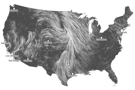
It’s a beautiful data graphic even as a static screenshot, but you must check out Hint.fm’s live Wind Map. Is it just me or is Wind Map the best presentation of macro wind direction and speed ever? It let me almost feel what that big low over the upper Midwest was doing yesterday, and if I was teaching weather I’ll bet this is a live graphic that would help students truly get it. And while the two talents behind Hint.fm may characterize Wind Map as “a personal art project” I can’t help but wonder how this presentation style and data source might benefit boaters…
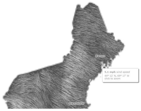
One thing that caught my attention is the fact that Wind Map is based on surface wind data forecasts that are “revised once per hour” at the National Digital Forecast Database. I failed to find detail on these forecasts at that site — like how granular is it? — but at several spots I checked the near-term forecast corresponded closely to real-time ground observations. Note that you can hover your cursor over Wind Map to get speed detail and click to zoom…
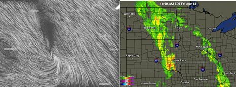
I also compared Wind Map to NEXRAD precipitation radar, and you can see below how the storm cell near Sioux City is accompanied by rapidly shifting wind. Here’s hoping that Hint.fm or someone animates the Wind Map style data presentation over multiple hours or days so we could get a sense of what’s coming our way, sort of like NEXRAD animations. It could probably be beautiful too. And wouldn’t it be nice to have on an MFD or iPad? Please check out Wind Map, maybe compare it to other data like radar and traditional wind barbs, and see if your sense of what’s happening is improved.


I like it. I bookmarked it to my weather folder. Thanks Ben.
Patrick Harman
Digging a little deeper I’ve learned that Hint.fm’s Fernanda Viégas and Martin Wattenberg “lead Google’s ‘Big Picture’ visualization research group in Cambridge, Massachusetts.”
http://hint.fm/about/
It’s also worth noting that Kurt Schwehr — one of the principal architects of the right whale detection system discussed last week ( http://goo.gl/kWE5B ) — recently joined Google as a “Data Engineer for Oceans”:
http://schwehr.org/
Outstanding! As you suggest, it would be great to be able to download GRIBs to an MFD and then have this kind of visualization bring it life. I’d love to see this data for the oceans in addition to the continental US.
When I posted this entry yesterday I did not realize that there would be so much severe weather in the Midwest:
http://goo.gl/OEkgr
Interestingly, I can see some of it on Wind Map but the data does not seem fine grained enough to show some fairly major storm cells still raging along a frontal line from Dallas to Kansas City right now.
While the Wind Map is ‘fun’ to view it certainly is to course grained for my use – the following Internet website has much better useful data that can be used when making weather decisions – check it out: http://www.wunderground.com/wundermap/?
NASA also did something similar with ocean currents but it’s historical, not live:
http://svs.gsfc.nasa.gov/vis/a000000/a003800/a003827/
The “Lows” coming off the Cape of Storms are incredible.
I first saw this on R-bloggers.com a couple of weeks ago:
http://www.r-bloggers.com/see-the-wind/
By the way, I use R to process and display sensor data collected from my N2k network.
Jon
This is a cool site. Interesting how the wind dictates where the storms are.
Holy cow, look what Hint.fm inspired:
http://earth.nullschool.net/#current/wind/isobaric/1000hPa/orthographic=-65.55,39.87,912
Click on “Earth” for viewing choices and more