
Navionics Mobile 2, with NewStand & more
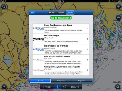
Months ago I heard that Navionics was planning to add boating magazine content to its mobile charting apps, but I didn’t know until the new 2.0 version came out that “my” Bonnier Marine Group was a lead participant! The implementation is pretty slick too. As long as your iPad or iPhone is online you can browse the “NewsStand” for cruising pieces relevant to your location or for articles listed by various subject categories or even ranked by reviews from fellow Navionics Mobile users. And you can download and read them two ways…
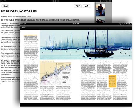
First off there’s a simple text version with custom font sizes and thumbnail photos you can click bigger, which works pretty well on an apps phone, and also available is a PDF file of the original magazine layout that’s my preference on a pad. All your downloads are organized into a “Library” that can be searched in various ways and that of course can be read wherever you are. There’s not a huge amount of content available yet, and here’s hoping that it continues to expand, but Yanks should note that if they turn on “Other languages” in NewsStand settings they can also get a taste of European boating pubs. Overall, NewsStand is a heck of a bonus feature for an app that already delivered a lot of value.
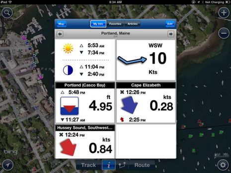
The various Navionics Mobile 2 apps also introduce an improved interface and a useful feature called “My Info”. When first opened, it will look for sun, moon, tide, current, and wind data for your location, but you can easily add more tide and current stations and even whole My Info pages for other locations. As you can somewhat see in the screen below, I now have four My Info screens, including one for Portland so I can quickly see what’s happening 70 miles to weather. Plus you can tap on a tide or current prediction to get the full mini app, and tapping on the wind speed will get Mobile 2 to download a large area of wind speed predictions and animate them over a few days. Of course you have to be online for wind data, and it would be nice to also get temperature, humidity, cloud cover, etc. but maybe that’s on Navionics’ road map…
And I’ve got some other suggestions for Navionics. For instance, I thought that the full Bing photo map I get when I zoom all the way in on Camden in Mobile USA HD was a new feature until I realized that the behaviour is only true in few places. But check out the valuable details seen on the screen below; you can even make out the shallows just northeast of Wayfarer’s travel lift docks. Of course the quality of these photo maps vary a lot — which is why it’s nice to have a choice of Google or Bing — and you need to be online to get them, but it would be neat if Navionics let you see the water portion of the photos if you want.
I’d also like the option to see a link list of all the POI info for a given screen area, as is done on the ActiveCaptain site and on Coastal Explorer’s Guide Book screen. It’s tedious to tap on the individual icons, especially in an area where there’s lots of interest. And it’s worth noting that Navionics User Generated Content (UGC) hasn’t caught on like AC yet, at least along the U.S. East Coast, though it does let users suggest edits for nav objects like bouys and ledges that AC doesn’t really cover. UGC may need an overhaul.
But no one can say that Navionics hasn’t been busy. Besides Mobile 2.0 — which is available for many of the iPhone and iPad chart regions now and will probably come to Android and Nokia versions eventually — the “Freshest Data” strategy seems to be fully up and running. At least I know that I can easily update the various 2011 chart cards I have as well as the Mac and PC app regions that I downloaded using the vouchers that came with those cards.
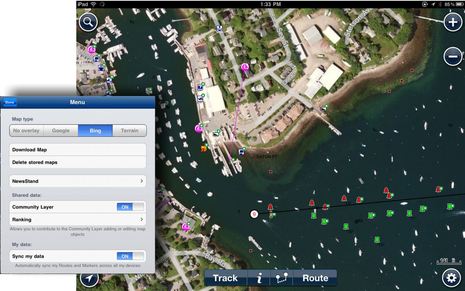
Note too that new “Sync my data” feature seen in the dialog box below, which is supposed to back up routes, tracks, etc. to Navionics servers and distribute them automatically to other devices like an iPhone. It isn’t quite working for me yet (possibly due to multiple registrations), but it may be for others (?). Plus at least theoretically the Raymarine e7 I hope to test soon should do direct Plotter Sync direct to Navionics Mobile running on either iPhone or iPad. The “Navionics Anywhere, Anytime” program I wrote about in Cruising World earlier this year is happening. Come to think of it, CW should make that article available for the Navionics NewsStand!


Ben,
I like the enhancements. You didn’t mention but I’m betting that it will cost me yet another fee. That is the disappointment with Navionics in particular. Their app’s life seems to be be very short. It is not available on iTunes quite yet.
Nope, no fee; Mobile 2.0 is a free update to Mobile 1, and at least the USA iPhone and iPad versions are on iTunes now. I got them as standard updates, and those screen shots above are all from the current app, not a beta.
There was a step change when Navionics completely redid their mobile apps last winter, going from a chart-region-included model to download-what-you-want from a larger region. I tried to explain it here: http://goo.gl/au4ek
In fact, the transition still isn’t complete. The Android app is still at Version 5.3, which means it’s way behind 2.0 (confusing!) and doesn’t have the features discussed above. I was impressed that when I opened it recently I was offered a new set of U.S. East charts, but I suspect that it will soon be replaced by a 1.0 or 2.0 app that will have to be paid for.
PS. I just checked iTunes for “Navionics Marine” and all the iPhone apps went to 2.1 on 8/12, which is also when all the iPad regions went to 2.0. So everyone who has the newer app for iOS should now have all the features discussed above.
I got confused because I took a quick look at Navionics Mediterranean HD on my iPad and didn’t see the new interface. In fact, it’s an old 5.0 app and has been replaced by Marine: Europe HD. It looks like some app prices have gone up a bit since the new app was introduced, like USA & Canada from $10 to $15.
Unfortunately the wind overlay feature has gone (changed). you use to be able to scroll through 72hrs as an overlay. Now the only thing I see is a small snapshot window you have to drill down to.
To be fair in Australia this was never very accurate anyway.
I have USA East HD Ver 5.0.4. I believe that you are referring to Marine & Lakes: USA HD. I did get it as a standard update. When I selected it I was asked to buy it.
Let me clarify. I did not get it as a standard update! I was asked to purchase 2.0
Right, I’m referring to Marine & Lakes: USA HD for the US app; the rest are called “Marine: xxxxx”. The original 1.0 app — which, according to Navionics, couldn’t be delivered as an update because it’s so different and covered such different areas — came out late last winter at a discount meant as friendly gesture to those who bought the East, West, etc. apps earlier on. Another way to look at it is that Navionics has developed seven whole number versions of their Mobile app, one of which they charged for.
How come in the pictures above you can see water in the background? Whenever I put the overlay on I can only see land areas.
Thanks
I tried to explain in text, Dean; it’s an occaisional bug that ought to an option, I think.
Like “Lookout Sailors” I too was an early Navionics Mobile customer. I find Navionics whole transition confusing. I think they should at least have an FAQ on their own website. After reading the comments on your site, I think such an FAQ would say: “We no longer want to support the small map regions that our early customers purchased. Sorry guys. We did upgrade your maps and applications last May. We have no plans for doing so again. Please buy the new app at full price. We would give you a discount but Apple’s commerce system famously does not allow that. Fortunately, our stuff is pretty cheap for what you get.”
One of the Problems with the navionics mobile app is that it is only available for Google Certified Devices at present via the Android Market
I am in the position that I have it on my HTC Wildfire, but cannot make more use of it by buying again for my WitsTech 7″ Android Tablet.
I have been in touch with both Navionics and Google about this, but a stunned wall of silence has prevailed, with Navionics saying that they do not operate any device restrictions on the App. So that then must be coming from the Android market.
So come on Navionics… have it available for direct apk download from your site, or have it available from third party App sites. I really want this new app on my 7″!!
Navionics must be losing a lot of available business by knocking out about 60% of the available android devices out there.
Most Google Certified devices are in fact Phones with Tabs a long way behind, it seems that Google hasnt yet caught on properly to the Tab.
Steve
Navionics tells me that 20,000 users have submitted 150,000 UGC entries since its full roll out a few months ago. It’s also clear in the email that they want MFD manufacturers to enable display of the UGC layer as it’s such a fast way to get chart corrections like missing ledges to the end user.