
MIBS # 5: C-Map, EarthNC, & MapMedia news
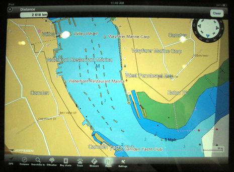
It’s a lousy photo, for sure, but Jeppesen C-Map has not yet announced its iPad charting app, let alone released screen shots, though I found it one of the nicest surprises of the Miami show. It seems that C-Map not only intends to match Navionics’ much appreciated efforts to offer inexpensive but detailed marine cartography on multiple apps platforms, but to do it even better. Note, for instance, the “CWeather” button on the menu bar above, and that C-Map has been working to overlay weather data on plotters since at least 2004 (though the then available mechanisms — a complicated cellular connection, or a data card transfer — were awkward). I’m not sure what CWeather offers today (the Jeppesen site says only European data), but we do know that a connected tablet or phone can make the download process very easy.
However, as the lousy photo shows, I was able to verify that the new C-Map app will include the sort of detailed C-Marina data I recently raved about. I also met the apps product manager and was impressed by his intentions to support mulitple platforms, open standard route and track formats, and more. He also told me that the iPhone/iPad version — which will be a free app that includes an excellent base map with reasonably-priced full-detail regions available for in-app purchase — is very near to release. Bring it on!
Which brings up another use for the proliferating chart apps. After Nobeltec demonstrated the wide choice of MapMedia charts in Miami, one writer asked how someone about to cruise, say, eastern South America could figure out ahead of time which chart database had the best coverage. That’s hard as the various online chart catalogs either aren’t very detailed or are difficult to navigate. However, once C-Map joins Navionics and Transas in offering all their chart regions in relatively cheap apps form, won’t that be the slick way check out coverage areas, with benefits? And won’t Garmin, Navico, and other chart suppliers start feeling an obligation to make their cartography available for accessory navigation?


Yes, a good question. Here’s another: will the pricing of these iThing/Android apps start to erode the market for overpriced (sorry) charts available for the high-end plotter systems from Furuno, Raymarine, Simrad, etc., or for PC plotters like RPCE and Nobeltec?
For example, I can pay $240 for the MapMedia Navionics chart pack for the Pacific Islands compatible with our Furuno Navnet 3D system. If I want the same coverage on Coastal Explorer I can pay something like $1,250 — and suffer the misery of the Chartworld Web site.
Or for $45 bucks get the whole shebang on my iPad. (I haven’t verified that all these charts have exactly the same coverage — I’m trying to illustrate a general point.)
Economic theory suggests that if iPad charting is sufficiently capable, these low prices will drive a lot of people to shift to using iThings rather than PC or hardware plotter alternatives. The chart makers could react in the following ways:
1. Raise the price of the iPad charts to reduce cannibalization of the plotter charts;
2. Lower the price of the plotter charts to encourage people to continue to buy them;
3. Accept the cannibalization at the low- and mid-end and raise the price of the plotter charts to maintain the top line in that category;
4. Do nothing.
Since #2 would mean reduced total revenues, that option seems unlikely. #1 is also unlikely since as you point out, Ben, competition in this category is increasing — and competition drives down prices.
My prediction is that we will see an increase in the price of charts for dedicated plotters, which is a bummer. But the chart makers know that there is a segment that will always want an in-dash plotter or sophisticated PC app, and that they more or less have those people over a barrel, especially given chart licensing complexities which reduce competition further. By contrast, smaller bracket-mount plotters like the Garmin 740 will face stiff competition from iThings and I wouldn’t be surprised if Garmin reduced chart prices on it’s lower-end units.
/afb
Thanks, Adam, but I don’t get why you think plotter chart prices will go up. I think that overall it’s the other way around. Note, for instance, how new C-Map plotters, like the ones from Standard Horizon, are coming with charts for all of North America and the Caribbean built in.
Your analysis doesn’t seem to acknowledge the prevalence of built-in charts for various highly boated areas of the world, or the fact that darn few boats go out to the South Pacific. There’s also the fact that iPads and other mobiles are nowhere near the navigation tools that PCs and MFDs are, which is largely why (I think) this currently large chart price discrepancy exists.
I think it’s the free ENC charts from NOAA that helps push these costs down. The chart data is now commodity, rather then specialty. These companies now need to add value to their chart sets by adding marine services, port photos, and more to justify their product. I know they all make money on selling charts… But I am surprised that no marine electronics company has manufactured a robust, marinized MFD, that can take a commodity SD card loaded with free NOAA ENC and BSB charts. I would think that would be insanely popular, as it’s free to keep the charts up to date.
Thanks Ben for mentioning the EarthNC iPad app!
It’s important to note that these alerts are for the North Atlantic Right whale. Federal and Massachusetts state law prohibit approaching a right whale closer than 500 yards without a NOAA NMFS permit. So whale watchers should sure to stay clear of these whales.
The end goal is for this not to be just a specific case. I hope that the USCG and NOAA will start to use the AIS Area Notice message for all types short term (non-chart) events. There are 126 possible notice types including such things as dredging, temporary anchorages, pollution/oil incidents, mines, damaged vessels in the water way, short term fishing closures, ice, critical storm warnings, VTS contact points, etc. ( pages 52-4 of http://vislab-ccom.unh.edu/~schwehr/papers/2010-IMO-SN.1-Circ.289.pdf )
The Boston Area is the first USCG/NOAA testbed for the Area Notice with the transmitter located at Cape Cod.
We will be sure to give the full details of the hard work by the many groups involved (Cornell, IFAW, NOAA SBNMS, and more) when the app is released and I hope that this type of application will pop up around the globe as a result of collaborations between the local Coast Guard, port authorities, and mariners to meet local navigation needs.
What about the cost to update expensive chart products for a specific brand of chartplotter? If you care to keep your g2 Vision charts for the coast of Maine updated this will cost you half of the original purchase price for that region, (a Regular region cost between $300 & $400). This is an expensive update and the primary reason chartplotter equipped boats are sailing the coast with outdated charts. Just think of how much money Garmin could make by charging a flat $75 to trade in an old SD card for an update to their G2 Vision. I would do this every year at that price. On the other hand, free government charts can be updated at anytime by any end user or more easily by using Coastal Explorer’s one click update service.
Richard, I think the update issue may come to a head as more people experience what it’s like to get regular chart updates easily, as with CE for U.S. charts. I haven’t tried it yet but Navionics “Freshest Data” deal is on:
http://blog.radioworld.ca/?p=781
The C-Map Max Pro charts in Nobeltec VNS and Admiral also have an easy anytime update feature, and that may also be true of the C-Map 4D charts coming to Standard Horizon and Geonav.
But in all cases except NOAA I think this update feature is only good for a year after you buy a chart set, and the new set, as you note, may be costly. I guess the idea is that the easy in season updating will get boaters more aware of chart changes, but it just might get them angrier about high annual renewal fees?
Ben, you’re right — I should have made clear that I was referring to the cost of add-on charts, rather than the base charts that most plotters come with. So my analysis refers to a much smaller universe of chart purchases (but one where I still think my expectation of higher prices will hold true).
As for iThing nav apps having nowhere near the capability of PC/dedicated plotters, I keep hearing stories of the gap closing rapidly. Example: there was a recent post on the Nordhavn Dreamers Yahoo! group which quoted a PNW commercial fisherman who successfully used the $9 Navionics iPhone app for emergency navigation when his primary GPS failed while running for a narrow sheltering harbor to escape 65 kt winds.
/afb
Should you EVER depend on a backup system that is less dependable than your primary? Isn’t turning to an iPhone somewhat like finding a dry match after you’ve shot all your flares? If it worked once its just a miracle; assuming it would work for everyone else is bad thinking and very bad advice.
Sandy, I wasn’t advocating dependence on anything. However, I’m wondering what data you have to support your notion that iThings are less reliable than “traditional” boat nav systems. I note that the iThing has a built in GPS, so no wires to corrode/chafe/short, and pretty good battery life that is also not dependent on any installed boat system. In a dry case they should be reasonably water-resistant as well.
I have no real-world data myself to point to, of course, but I don’t think there’s a slam-dunk case for reliability that favors the dedicated chart plotter. (He writes, while trying to troubleshoot a nasty N2K bug that completely locks up Furuno’s top-of-the-line black box.)
/afb
The answer to iThings reliability is in the warranty. Specifically, Apple’s warranty: This warranty does not apply: (a) to consumable parts, such as batteries, …(d) to damage caused by accident, abuse, misuse, liquid contact.
Note “liquid contact”. How explicit do they need to be that iThings are not intended for use around water?
And to add insult to injury, Apple warranties do not cross country boundaries. I bought an iPhone in the UK and when I called Apple in the US they said, “sorry, talk to the UK”.
Furuno may have a nasty N2K bug, but call Seattle from Tonga and they’ll help you out. And they won’t complain if your plotter has some “liquid contact”.
Russ, all good points, but I note that warranty and reliability in the real world are not the same things. And of course I could carry nine backup iPads for the price of a Navnet3D plotter. 🙂
The arrival of the general computing device into mainstream boat electronics has long been heralded, but actually never arrived. I dont think iThingies will either. Firstly build standards of mass produced iThingies is not that good, based on the iEarThingy. Reliability will be its downfall.
Secondly what will happen as iThingy increase their presence, is that MFDs will get more powerful and more capable. Theres already been an explosion in the last 2 years of MFD capability.
Thirdly the Marine electronics space is tiny, with many proprietary and closed product systems and designs and no ecomonic benefit to thoese manufacturers to open up their devices to other developers. ( Radar, networks etc).
Sure well see more iThingyies, but not in a dominant position.
Dave
The good news for right whales is a total population estimate of about 430 individuals up from the usual 350 number often used, however, a quick internet search doesn’t seem to show this higher estimate unfortunately.
Here is a somewhat more formal opinion:
“Executive Jet Approved to Replace Paper Charts With iPad
February 17, 2011 — The iPad, along with a mobile application provided by Jeppesen, has won approval by the FAA to be used in lieu of paper charts on Executive Jet Management aircraft, a subsidiary of NetJets Inc. The approval to use the iPad as the sole reference for electronic charts in all phases of flight is the first of its kind. Electronic Flight Bags (EFBs) have been approved for use for several years but the iPad is by far the most compact tablet computer employed to date as an EFB.
Rest of article here: http://www.eaa.org/news/2011/2011-02-17_ipad.asp
Note that an iPad will be required for each pilot so there is some redundancy built in there, and it obviously doesn’t solve the waterproofing issue, but if its’ good enough for the FAA…..
Interestingly there are multiple major airlines working on the same approval, the major stumbling block at my airline is that Jeppesen is insisting on charging us the same amount for electronic revisions as they do for printing and shipping hundreds of pounds of paper revisions to us every two weeks. The company is absolutely refusing to, so it is going nowhere right now.
Adam, your issue appears to be price. It would be mine too but for a hard earned bias. In fact, I will be the first old fart on my dock with an Android Tablet running marine mavigation software and charts when they reach my minimum criteria; daylight readability and under $500, my personal threshold of pain. But it will be a toy, among all my other electronic trinkets. My primary nav will always be a Marine Chartplotter with the absolutely latest charts, my backup will be a handheld marine Chartplotter that uses grocery-store batteries and is kept in a Faraday enclosure.
I spent 25 years of my life as an accident Investigator with the NTSB. Big smoking gun causes are rare. What kills most people are a succession of little failures that add up to more than the pilot or skipper can deal with. I can foresee accidents at sea with an iToy being a contributing cause. I have a pretty good crystal ball.
If you imagine that all your voyages over the horizon will be balmy, you are going to be a statistic. If you are prepared for wet, cold, stormy conditions where everything starts breaking down, you area a survivor. You get to write your own report!
The FAA is happy with a couple ipads (or similar) in the cockpit instead of a current set of Jepps. I am too, given that a cockpit is dry and shaded.
The phones-n-pads-are-toys crowd will certainly jump on the rescue of the 36-foot sail boat “No Problem”:
“In lieu of having no navigational equipment to rely on, such as charts or a compass, the boater relied on his cellular device which was rendered useless after getting wet.”
http://www.tmcnet.com/usubmit/2011/03/10/5369462.htm
Ben next time you may want to push the home button and on/of switch at the sametime to make a screenshot. , will make much better quality picture to go with the story.
I love how easy it is to make screen shots on Apple mobiles, Ruud. It’s less easy, though, when it’s not your iPad and it’s not connected and no one has the needed SD card dongle etc. Then again, C-Map could send me a screen shot like that without too much trouble 😉
More iPad/iPhone charts! Imray and Tucabo team up with raster charts of the UK. Not cheap, but there is a free intro version with large area charts of the English Channel. The app itself seems quite well done:
http://goo.gl/M8rgv
Memory-Map also has UK Admiralty charts, downloadable to the iPhone/iPad, at £25 for the complete set.
I think we are the only company to offer reasonably priced charts of Australia, at $65(USD) for half the country.
We also have New Zealand, and of course, a free set of NOAA charts.
Meanwhile, we have an Android version under development.
Richard Stephens
Memory-Map, Inc.