Monthly Archive: October 2010
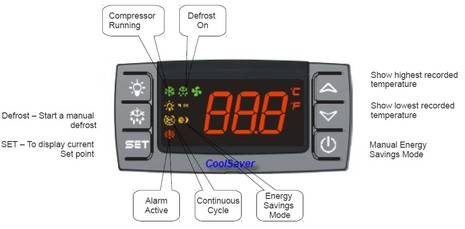
The final product photography isn’t finished yet, but there’s certainly enough info up at CoolSaver.net to discuss this interesting advance in refrigeration control for power-conscious cruisers. What seems unique is a feature called Charge Sense, which can push fridge temps down to a user set low when there’s excess power available from an alternator, generator, or solar array, and conversely minimize power use when it’s scarce. Which, if it works well, could be a pretty big deal on a lot of boats, including my own Gizmo…
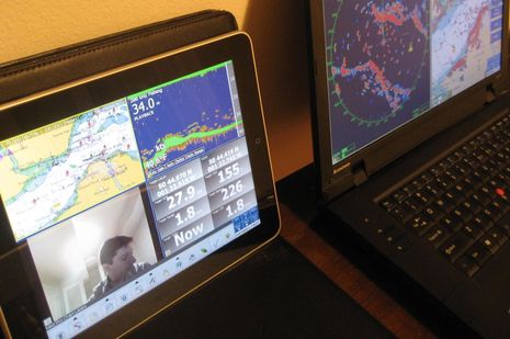
It’s not just the new edition of Coastal Explorer that can play nicely with an iPad. In fact, it turns out that anyone running Nobeltec Admiral v6.5 or higher can get their iPad to show a variety of independent screens like the one above. That’s because Admiral has long supported the extended desktop capabilities of Windows, as well as touch screens. But Nobeltec Product Manager Bill Washburn, glimpsed in his own camera above, warns that screen refresh rate is marginal, at least at this point…
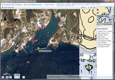
An interesting solution for the Jonesport uncharted breakwater problem came all the way from the S/V True Love in La Paz, Mexico. Skipper Bill Stockton has written a program called ChartAid which can turn Google Earth photo maps into BSB format so you can navigate on them in programs like CE, Nobeltec, and Chart View. I did get an “Invalid BSB” warning when I installed the chart Bill sent into CE, but it works fine. As you can see above, the registration with the official chart looks spot on, and my vessel, track, and route, plus data sets like GuideBook, overlay properly. Even the “properties” make sense, with the possible exception of the Source date. And apparently it’s easy to make such photo maps with ChartAid…
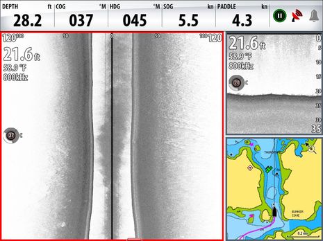
Rats! I thought I’d recount some of the summer’s Simrad StructureScan experience since I mentioned it in Monday’s entry about chart problems, and while I was pleased to find a screenshot taken right in the Thorofare discussed…I failed to snap one after passing over the disputed danger. But you can see how flat and smooth the bottom is just short of what is supposed to an “awash (at low tide) rock”; please trust that the bottom stayed just like that as I drove right over the annoyance, as I posted on AC. But maybe you can’t intrepret the screen above well until you see more of what this side looking technology can do…
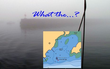
Yup, the first time you cruise into Sawyer Cove in often foggy Jonesport, Maine, you may be surprised to discover that there is a substantial steel and concrete breakwater extending from the fixed light almost all the way to the Eastern shore. That’s because the structure still hasn’t made it onto the official charts, or any chart I’ve seen, even though it was built over 20 years ago, and even though the NOAA ENC inset above was updated on 9/17/2010. I mentioned this when I first wrote about Sawyer Cove in August, but that entry was largely about how poorly any of the guides — digital or paper, professionally written or crowd sourced — covered the facilities available. Since then I’ve learned more about the breakwater situation, and it’s depressing…
Back in April I enthused about the improved Guide Book section seen in the Coastal Explorer 2010 beta, soon to be official in CE 2011, but I didn’t mention discovering all the UK and Euro data that’s had been added using CE’s own built-in Guidebook tool. I’ve played with the tool myself, and it’s easy to create a POI with free form text, a link, and even photos. And it’s easy to sync/cache all the Guidebook data stored on CE.net, like it is with ActiveCaptain, Atlantic Cruising Club, and other data sets (when your PC is online). But for some reason hardly anyone in the U.S., aside from the Pacific Northwest, has contributed Guidebook data. So how is it that England and nearby coasts are studded with all sorts of valuable port and marina Guidebook POIs — and some more fanciful items, like that nice shout out to Panbo above? And what might it say about this whole crowd sourcing thing?
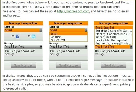
As best I can tell, Rich Owings at GPStracklog is the first to write up a field test of the interesting wireless pairing of a specially designed DeLorme handheld mapping GPS with a specially mated Spot Satellite Communicator, and he’s pretty excited about what he found. Yes, you can type a 41 character message from anywhere with Spot coverage and post it to Facebook or Twitter, or send it to one of several pre-defined e-mail/text groups. And that includes quite a lot of ocean and coast, as we saw even with the first generation Spot Messenger. And even though DeLorme’s core clientele are terrestrial types, I notice that the PN60w/Spot system (and its PN-Series siblings) now support Navionics Gold SD chart cards (and HotMaps lakes), as well as NOAA raster downloads…
How about three cheers for Vincent Argiro, and guys like him willing to enthusiastically test the bleeding edge of marine technology. That’s his first boat above, an Alerion Express 33, which is also the...
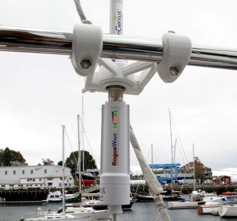
Here’s a beautiful sight, and I don’t mean my float mate’s headsail furl. Those six LEDs on the Rogue Wave WiFi transceiver are showing (from the bottom up) that it’s getting power (via the Ethernet cable), that it’s made a connection with a down below computer (or router), and finally that its connection with an onshore hotspot is good enough to light up all four signal strength indicators. And I can attest that if the hotspot itself has a good Internet connection, this high power WiFi radio is ready to rock. I’ve been pretty pleased this season with the performance of the Wave Comet I wrote about last March — it far outperforms the WiFi built into my PCs or phones — but the Rogue leaves the Comet in the dust…
Big, big news in the world of user generated content (or UGC, or crowd sourcing, or whatever we decide to call it): Navionics Mobile 5, rolling out around the world as I write, supports UGC, big time, and it’s central to the company’s “Navionics Anytime, Anywhere” vision of the future. Those screen shots above — which show the new “Community Layer” turned on and off — are from a beta of US East 5.0 running on the Panbo test iPhone, but most all of that UGC work was done by Navionics founder and chief visionary Giuseppe Carnevali when he cruised up here in early September. It would be hard to overstate Giuseppe’s enthusiasm about enabling interested Navionics users to share data of all sorts, some of which can be validated and added to the company’s regular chart database for the benefit of all users…


Recent Panbo Comments