
MFD shootout #1, tide predictions

I may regret that title eventually, though I’ve just been cruising with four premium MFDs for two weeks, often using them seriously for four or five hours a day. But that doesn’t mean I’ve learned every nuance of these complex beasts, or that I’ve developed strong preferences. Actually I have (mostly minor) complaints about every one of them!…even if they’re all way better than the electronics I used around this coast 40, 30, 20, 10, even 5 years ago. I’m going to start with something fairly simple…
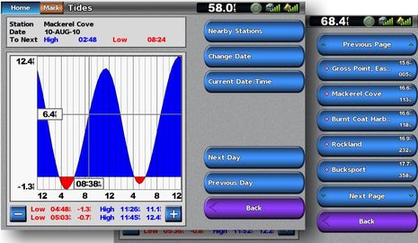
I was a little surprised to discover that the Simrad NSE doesn’t offer current predictions {Wrong, see comments below and here), but it seems the quickest at pulling up a tide graph (above). Hit the “Pages” mode key (Simrad calls them Direct Access Keys, and I’ve come to love them), spin the rotary knob a few clicks to “Tides”, press/click and voila…the nearest tidal station prediction for today. Up/Down cursor keys get you different days, and the (context) Menu key gets you the list of nearby predictions. Note the legible fonts and font sizes — something I see and like everywhere on the NSE.
As for current predictions, here in Maine the official data is fairly useless because the coast is so complicated — we learn to use tide level, geography, and ultimately pot buoys to figure things out — but I’d be a little miffed to learn my NSE can’t tell me, say, which way the four knot +/- current in the Cape Cod Canal is running. But there are so many sources of that data these days, from smart phone apps to insurance company paper freebies to just about every computer planning or charting program. That’s also why I can’t get too exercised that the Furuno NavNet 3D MFD12 on Gizmo’s bridge doesn’t have any tide or current predictions at all {Wrong! See comments, and follow up tomorrow}. But that does make it the odd man out (along with the inability to save screen shots, which is somewhat a personal bugabear, given what I do, though not completely).
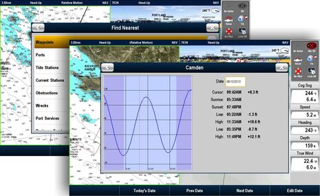
The Garmin 7212 — and this applies to every Garmin I’ve tried — is nearly as quick as the NSE. Home/Information/Tides is just as quick, in fact, but then when you go Back, you have to again choose which navigation screen you want, whereas the NSE just goes back to where you were. The Garmin, like the NSE, makes it graphically clear where you are in the tidal cycle, and unlike the NSE, lets you key in any date in the future (that’s where the 7212’s touch screen works especially well). The Raymarine E140-Wide isn’t too shabby either…
 Though if a tide (or current) icon isn’t in sight on the Raymarine chart, you have to remember that you can hit the OK button to get screen info, than the “Find Nearest” soft key to search tides, currents, and other good stuff. I don’t really understand why the search box, tide graph, etc. isn’t full screen, but maybe it is on less than 14″ displays. I also think that the graph and table could be designed for better legibility (see the other two), and ditto for the data bar seen at the right. It’s attractive looking, for sure, but in my view actual dynamic data should almost always be bolder than labels. Then again, my E140 Wide is still running the software that came with it last Fall, an issue that will come up again tomorrow when we look at 3D chart screens.


When I used my MFD8 in Maine two years ago it had tide data. I thought the UI was pretty awful, but it did have tide data as I recall using it regularly when anchoring. Did they really take a step backwards?
MaxSea 1.9 has a few in Maine, at least Rockland, North Haven and the Penobscot River. I’m surprised that none of those made it into the MFD.
That said, I found the Furuno tide data to be very spotty in the Caribbean, but not a big deal since there isn’t much tide there anyway. It will be a much bigger deal on the Pacific side of Panama.
My bad! NavNet 3D has tide and current predictions, with on screen icons or graphs, and quickly accessed with the Rotokey I’m told. Will check out myself tomorrow, and not sure how I missed them, execpt…too many gizmos, too little time.
Yeah, MSTZ and NN3D have tide/current data, but I have found the current data to be universally wrong, in magnitude if not in direction, in SF Bay. This is especially noticeable since I run CE right next to MSTZ, and CE seems to be right on.
I have the Simrad NSE 8 on my own boat, and have recently installed a 5212 Garmin on a client’s boat, personally I like everything the NSE does. We think it does it better. It is very fast, easy and intuitive to use. The screen is bright in sunlight and the rotary dial is great. We have the Navionics chart for our area…South Florida and so far no issues in the short time we have used it.
Adam, I’m surprised that you are seeing different current predictions from CE and NN3D, as I thought that all predictions are based on NOAA formulas and constituent data that are freely available to all. I’ll do some comparisons when I get out to Gizmo today.
Ben, after installing and commisioning the Furuno NN3D system this past winter, we have found multiple areas where the software really falls short in terms of user friendliness for the crusing boater. The Current issue is just one of them. Following is just one quote from an on-going communication with the folks in Camas and their response to date:
#9) Unable to access Current data for anything other than real-time display – This is another major oversight that makes trip planning with the Furuno system an endless series of back and forth between the MFD and paper charts and tables. At least the tide data can be accessed, albeit rather clumsily, for a user-entered date & time. But the equivalent feature for currents, much more important in trip planning, is just plain missing. Very frustrating.
(Response): We will look into this but we have no ETA at this time.
(My Response): OK. Guess we’ll keep the Capn. Jacks handy (or my iPhone) until that gets integrated.
If you’re interested, I have the whole Word doc containing 20 some-odd other issues that we’ve been debating back and forth, most of them still unresolved. Bottom line – they have a great reputation for quality hardware and pretty good local support, but the software has a long way to go before it’s anywhere near as capable or user-friendly as Garmin and maybe others.
Thank You for reminding me…
Quicks Hole between Buzzards Bay and Vineyard sound last summer
I took photos of it, because I was floored by how wrong NN3D was on the currents. I mailed MaxSea but never heard anything. Have a look…
The chart says 14.2 knots and you can see the #2 buoy standing straight up.
http://picasaweb.google.com/lh/photo/dXHZ1bacoeOVLchRQy1oRHvpk8Mkr0HBlLvzWMBoM_U?feat=directlink
and
http://picasaweb.google.com/lh/photo/AqIvyKfUmo6qUNP9Xf-BOHvpk8Mkr0HBlLvzWMBoM_U?feat=directlink
SVPenguin, Do you have the Time Offset set to Eastern Time, and DST enabled, because that’s local time, and I think the MFDs come set up with a -12 hour offset (Japan, I guess). I just discovered that on Gizmo, and it makes quite a difference 😉
Ben is dead on about having the time offsets correctly set in your chart plotter. Tides/currents are all calculated using Zulu, UTC, GMT times (these are all the same things). If the offset is not correct, the calculations will be skewed in time. For example on the east coast of the US, the current time offset is -4 hours, and hence the tides/currents will be skewed by four hours, if the offset is at zero. Most chart plotters come from the factory, with the offset set at zero. Garmin will adjust for daylight savings time automatically (if you set it that way), and if Congress doesn’t mess with the dates, and they have on occasion in the past. On a Ray/Furuno, you have to manually change the offsets. When we “fall back”, the differential for EST will then become -5 hours. I can’t tell you the number of times I have seen a chart plotter with the incorrect time offsets.
I’ve been using Navnet 3D MFD 12 for about 18 months and I think the tide information is very easy to access via the tide icons. Make sure you have them selected in the menu via the overlay feature selected by the rotor key. The rotor key can be customised as well so make sure that feature is not turned off. It’s very easy to scroll to future tide information. I’ve been helping one of the guys at our club install a MFD8 and max sea time zero software and so far in playing with it at the dock it’s been amazing. We have an internet connection via his cell phone so we’re able to download weather files from the maxsea website and overlay them on the Timer Zero maps. The chart is shared between the MFD8 and maxsea which makes a net package.
Ben (& co.)
Thanks for the tip on offsets. I will be down at the boat next week and try to find the setting. I can’t find anything in the NN3D manuals on this Searching on “time”, “offset” or “current”. My photo shows the correct local time on the display so I’m still stumped.
While we’re listing other shortcomings my to least favorite “features” of the MFD8. The Day/Dusk/Night setting and the alarm acknowedgment/clear both of which are buried deep in the menu structure. When the alarm is going off I want to be able to acknoweledge and clear it and deal with the situation.
SVPenguin: NN3D certainly has many settings. If your system is displaying the correct local time in a data box, then you should be good to go. If it still has grossly incorrect tide/current data, I suggest you call Furuno. In my experience their telephone support is quite good (though only M-F, as though boaters don’t have jobs…).
Regarding the Day/Dusk/Night settings, hit the Menu button, then select Global and finally the General tab – certainly too deep for something that is used several times a day while underway. I’ve also had a problem with this setting in that if you leave it on Night too long, you can’t read it to change the setting to Day. I think more creative use of the front planel Brightness button might be an improvement.
To clear an alarm, try the CANCEL button on the front panel.
Another useful display feature with the Furuno NN3D displays is the viewing angle that can be adjusted through the software. When standing up viewing my display is was very good but whn sitting down it was terrible. I found a viewing angle adjustment which now increases the viewing angle whether standing or sitting.
Agree Russ, the alarm can be silenced by pressing the CANCEL key. There is an alarm log that can be viewed but I cannot remember how/where it is. I’ll check it out when next on the boat.
As for tides, Furuno NN3D tide information can be upgraded via an SD card upgrade which is an improvement.