
Alliance for Safe Navigation, & chart reality questions
The photo is from a BoatUS press release discussing how it, NOAA, and several other organizations are concerned that many boaters are using outdated charts. They’ve even got a survey going (quick and easy), and I bet the results will confirm their worry. But while the new Alliance for Safe Navigation they’ve formed leads to a neat Notice to Mariners tool I hadn’t seen before, I worry about more than keeping up with NOAA’s chart changes…
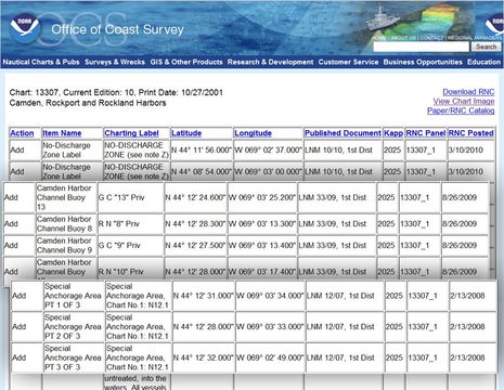
No offense meant to NOAA, but I question its ability to manage the data it’s already amassed and to keep up with ground truth. When I look up my local chart 13307 at the nifty NTM site, I notice the odd new private channel buoys — the real ones aren’t cans or nuns, aren’t numbered, and most aren’t where charted — along with the special anchorage boundary that somehow got an extra corner on the ENC version, a confusion that’s now being copied by some of the commercial chart makers. (As illustrated here and here.) Admittedly these are fairly trivial matters, but if they can get screwed up en route to your chart plotter or charting program, what else has?
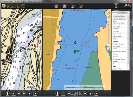
 I also worry about electronic chart presentations. Remember my friend who hit a slightly submerged crib on the Kennebec river and wanted to blame his Garmin charts? Well, check out the BlueCharts seen on that entry versus the RNC and ENC views of the same area below. I don’t think the ENC, though zoomed in, warns folks about those cribs nearly as well as the RNC/paper chart, or the Garmin chart.
So how do you all deal with these issues? Do you keep your charts updated? Have you seen errors? Where else do you look for info? Do you still use paper charts sometimes (honest answer, please)? Which electronic charts do you favor, and why? Do you have tricks to get the presentation optimal?


Ben, We use C-Map with our plotter and NOAA charts on the computer, BUT, we always have paper charts on hand and out in use when under way. If anything on the plotter looks strange or unclear we refer to the paper charts. The paper charts are always used in the daily planning and the electronic charts are used along the way. We make notes of problem areas in advance and keep those notes at the helm. IMO relying on electronics alone is foolish for the prudent Skipper. And of course we use the most current paper charts available.
I’m in agreement with the remarks posted by Capn. Chuck. That’s how we run Acorn, cruising the coast of Maine, New Brunswick, and Nova Scotia. It’s all done from paper charts (about 50 of them are kept) with Raymarine E Series widescreen backup. I still mark course lines and time notations in pencil on the NOAA charts, and was quite surprised (well, maybe horrified) to read in Ocean Navigator this month that paper charts are “a thing of the past” and not necessary. Other reasons for paper charts? Sometimes the Raymarine plotters just drop a track line without warning, they have frozen up twice, and I think that generally the NOAA charts provide more detail than Navionics does in Mid-Coast Maine waters where navigating is a little complex on occasion.
Ben, I wonder how the ARGUS project data will be updated to NOAA? Then how will it be distributed to mariner’s? I am one that believes in having redundency when it comes to chart plotters, GPS antennas and heading sensors. My wife and I carry paper charts as well but some of our most recent paper charts we purchased have data from well over 10 years ago.
Bill Lentz
Cruising in Southeast Asia has some interesting revelations and sometime scary situations when using electronic charts.
This screen shot in Indonesia http://yachtvalhalla.net/photos/Ed3vsEd2.jpg shows a track comparison between the 2009 Ed3 Vector/S57 chart and the 2010 Ed2 cm93 chart.
Terry
When they tell you it’s not about the money, it always is. Good subject, a complex one and a perennial issue for all navigators. There are few ways to do this inexpensively. Short of having a nav systems that uses the free downloadable NOAA charts. Most of us have to purchase charts at your local marine retailer, and hope they aren’t outdated inventory, or buy new chart software chips. The chips are expensive. Garmin’s preloaded map updates, are about $90, and come on a SD card, but remember, when you use a G2 card, it over writes the preloaded chart data, and uses the G2 card for all of the mapping data (as many know, you can fall off the edge of the G2 vision chart, and end up on a blank screen), so you would need to update that also, for more money.
Navionics offers a somewhat complicated, and Machiavellian trade in system, involving your original purchase receipt, varying rebates based on the chip price, make and model of chartplotter, and sending your chip to them. It gave me a headache trying to read and understand it.
Maptech charges over $100 dollars for chart updates, and yearly tide tables.
Compound all of this with errors on the map chips (There is always one more bug), the occasional chart registration issues at varying scales, GPS fix performance, and you can see why the attorneys always have the manufacturers put a prominent notice saying to the effect, if you hit something, it’s not our fault, and we told you so. Where I live the passes can change overnight, and they have bitten many boaters who have assumed the data on the chart is correct, even if the chart is perfectly up to date.
So wouldn’t it be nice if you could stick your map chip into your computer, and say “update please”, abet for some smaller price. or there was a utility that would allow you to add the changes to your mapping data as the “notices to mariners” appear. Neither option seem probable at this point in time.
Thanks, Bill. Note that the Alliance survey linked to above has “what if” pricing questions in it, which is one reason everyone is encouraged to take it.
(Everyone should also click on Bill’s link above for some great installer, and general, ranting 😉
We do the same as Capn Chuck, but at the same time we are aware that sometimes the printed maps and computer charts are wrong. Recently, in the Alligator River in NC, we listened on the radio to a boater who had set his autopilot to follow the magenta line, right onto a shoal. The channel markers showed the correct channel with 12 ft of water.
All the electronics in the world are no substitute for common sense.
I have only ever used raster charts for electronic navigation (never had a chartplotter, only the “Chart Navigator”-branded version of Coastal Explorer). The western baltic is covered very well by a private chart company “NV” using a proprietary format NV.digital that is supported by CE. Four chart sets cover the western baltic. The set of four is EUR 198 per year. The set includes CDs with raster charts that are exactly the same. When you buy, beginning this season, you receive a monthly email with updates to the electronic charts as well as updates to the paper charts as a PDF that you must print to a color printer, cut and glue to the charts.
I skip the printing, cutting and glueing after having done it a few times.
Because the electronic and paper charts are the same image and because you more or less have to buy them together and because EUR 198 for everything for a full season is OK, I always have the most current paper and electronic charts – except for the glueing part. I plan the route in CE, then pull out the few paper charts in question and put them on the salon table before we leave to any place where we haven’t been a hundred times.
There is a Panasonic CF-08 display in the cockpit showing the image of the laptop at the nav table (1024*768 res).
I then usually don’t look at the paper charts again underway. Once we were hit by an ugly gust that caused the laptop to launch from the chart table, dropping 7 feet and hitting the icebox exterior with the lid open. At that moment I commended myself for having the correct paper chart right there on the table. Later, the trusty old lenovo booted up as if nothing had happened after I clicked the keyboard back in and I now have a restraining string connected to where you attach the theft prevention cable.
I expect things to be entirely different when we depart on the atlantic circuit. A “conservative” (according to Hamburgs main chart dealer) set of paper charts for the trip would be a stack a foot high costing the same as a brand new compact car so that isn’t going to work. Electronic charts will be more affordable. I am looking in the direction af NV for the caribbean, ARCS (Admiralty) for the english channel, france, bay of biscay and atlantic islands and NOAA for the US east coast. Using ARCS means I will need another charting application in addition to CE where seaPro is a prime candidate. If Nick wanted to step in and add ARCS support to Expedition, this would also be highly welcome. For paper chart backup I’m thinking about the printing function offered by CE (seaPro I don’t know) and a color inkjet and a very basic set of paper charts (no more than one inch). I admit this would not meet SOLAS carriage requirements but I wouldn’t be stealing anything and I could still do the trip. If I went fo the whole foot, I couldn’t. I remember a World ARC or other survey where one participant reported having spent as much on charts as on *everything* else combined (boat repairs, flights home, dockage, food…).
Fyi, Maptech has Bsb charts for the English Channel.
Thank you, Nick. This is noted. I am also aware that Expedition supports NV.digital and their chart portfolio also covers a good portion of the european part of the trip so would be an alternative. My interest in ARCS is based on the recommendation of said Hamburg chart dealer (HanseNautic) as an expensive but premium choice that is very current.
If I find myself in an “either BR24PC or ARCS” situation, I will definitely explore the alternatives which are Maptech BSB and NV.digital.
Although we continue to use paper charts along with electronic navigation, the cost is immense. In three years of world cruising using ARC paper and electronic charts I’d estimate we have spent more than $35,000.
For electronic charts, I use the NOAA raster charts (which are pretty easy to keep current, and also free). For the Bahamas, BVI, and Dominican Republic, there are CYC charts in paper and BSB.
Where therw are no BSB-format electronic charts (Bermuda, for example), which I can also print, with the 42″ plotter that is a basic tool of the designer, I use navionics, which seems to offer the best coverage for the buck. Of course then I do have to buy the paper charts too.
What I would not do is tie myself to some proprietary format. Acceptance of standards is increasing in every area of electronics.
In the Netherlands we have about 1000 map changes per year for coastal waters. The paper maps are updated every year. Since there is no easy way to update paper maps and they are outdated by the time they get printed (electronic maps are even worse), I’ve started a private free service.
All the NtM (called BaZ in NL) are translated into a list of PoI’s [1] a navigation program can read/import (e.g. GPX format). The PoI list + NtM text can be downloaded with 1 click from a PC.
In addition I’m experimenting with Google Maps + chart overlay to show all changes in Google Maps [2].
[1] http://www.emarine.eu/en/download/category/4-bazpoiall
[2] http://www.emarine.eu/baz_poi_all_large.html
At Fugawi X-Traverse, we have been working on this problem for the past year and a half. We now have charts available from Navionics, Canadian Hydrographic Service, NV.Digital (Caribbean, Northern Europe), as well as Sweden, Norway, Finland, and Brazil with more coming soon. The Navionics charts are vector and available in regions covering most of the world, while the rest of the charts are raster. We even provide ocean condition (current, temperature, altimetry and chlorophyll concentration) charts for offshore fishing as produced by Hilton Realtime-Navigator.com.
All charts are updated on the X-Traverse server as and when they are updated by the manufacturer, including Navionics charts. Chart updates are free within the calendar year in which they were purchased. Hilton charts are updated daily or hourly.
Charts available on X-Traverse are compatible with – and available for direct download to – Fugawi Marine ENC or Geonav MapMapster for Windows 7, Vista and XP; GPSNavX or MacENC for Mac OS X; and iNavX™ App for iPad™, iPhone, or iPod touch.
Whenever a chart region is updated, subscribers receive a simple email indicating the chart update and given quick instructions – generally one or two mouse clicks – detailing how to update the charts in their software or mobile device.
Our goal is to facilitate boaters who wish to use their choice of up-to-date marine charts for direct download to their choice of navigation software, with simple and easy-to-understand chart updates.
Over the next few months, we will be releasing more chart content, and making it available to more marine navigation software products, on more devices.
See http://www.fugawi.com/web/x-traverse/ad_landing_x-traverse.htm
— Robin Martel
http://www.x-traverse.com
http://www.fugawi.com
Ben: The problem with this whole fantasy of “up-to-date” charts is that in reality things change constantly. My ancient paper charts carried onboard, some more than 20 years old, carry numerous notations and remarks that are important to my navigation. These personal marks have never appeared on government charts and never will: a buoy surrounded by lobster pots, a place where the wind bends around a point, a place where one often sees tail lights from cars ashore at night, a place where consistently for numerous years the government printed the magenta line going on the wrong side of the buoy, a safe short cut across the shallows, etc. etc. I would lose all of this valuable information if I supposedly “updated” my charts by buying new ones. And, in my experience, most government updates have little bearing on the navigational safety of small craft. Plus, there are numerous places where the current government chart is at an inferior scale to the older charts, or doesn’t include information that was formerly there. The government is not very concerned at all with shallow waters and areas outside of major shipping lanes. They rarely resurvey these areas and frequently reprint incorrect information for many print cycles. Sometimes this goes on for decades. Sure, if you do nothing but sail buoy to buoy and follow shipping channels into major harbors having the latest charts is useful, but if you venture off the big ship path you lose a lot when you get rid of your old charts.