
Coastal Explorer & ActiveCaptain, YES!
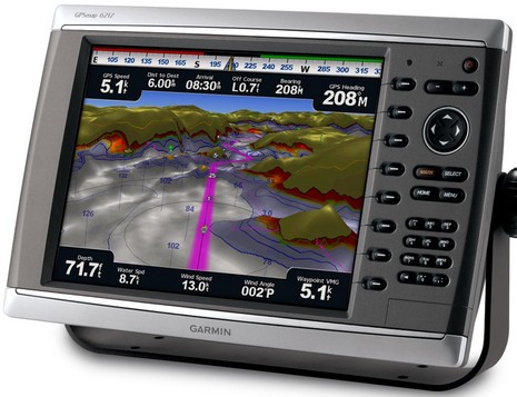
Garmin just announced several new products which will be shown when the doors open at METS tomorrow morning. The 6000 and 7000 series are very much like the successful 4- and 5000 series except that apparently they’ve got enough processor speed to warrant a new expression for how fast and smoothly they pan and zoom charts — Garmin G Motion. They’ve also got backlighting that dims down more than the originals, and backlit keypads. And the big mama 15″ touch screen 7012 and 7015, which will retail for something like $7,000, have a feature that’s a first for MFDs, I think — VGA input, so a user can use them as a monitor for a down below PC. Interesting! They also have four regular video inputs, and I’m told that all the new machines can display video input full screen (which was a problem). Though it’s not in the press release, I also understand the 6- and 7000 series will have limited distribution, which means they’re mainly meant for installer/dealers, a crowd Garmin has slowly been winning over. Garmin’s new Class B AIS is no slouch either…
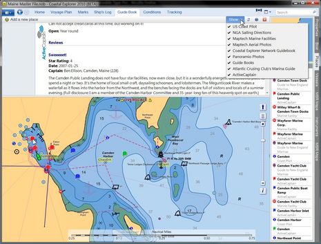
Take a good long gander at the full size screen above. That’s Coastal Explorer 2010 in Guide Book mode, which already offered a wealth of port information, but as of last night (announcement here) can also show ActiveCaptain community generated info. The particular detail shown is my own enthusiastic take on our Public Landing, written when AC first launched (and still true), but notice how you can also access Atlantic Cruising Club’s professional view of the facility, as well as three different angles on Wayfarer Marine and the Camden Yacht Club. The chances are good that a visiting boat can find all the information it needs in this one spot. In fact, while my entry on the neat ACC integration was titled “CE & ACC, great but not enough! Part 1,” today Part 2 is pretty much irrelevant…
The new Garmin AIS 600 is quite similar in architecture to Raymarine’s AIS 500. But whereas it’s coming out a little later, I dare say it will deliver all the standard NMEA 2000 AIS PGNs (the Raymarine needs an update to send standard Class B static data) to any device on the boat that can use them. Garmin also claims that its VHF antenna splitter does things a little differently, something called ClearTrack which ensures that all AIS transmissions get out, even if the VHF radio attached is being used to transmit. Plus Garmin is already well along with excellent integration of AIS, MFD, and VHF, as I’ve been seeing with its VHF 200. Garmin’s IMO-like method of displaying AIS targets as active and inactive is also good, I think, and they’ll let you see them in futuristic 3D too. And as of the recent software update 5.4, they’re dealing with the over enthusiastic alarming problem too. I think they even added an MMSI input field so that Garmin MFDs can understand that N2K attached Navico (and Simrad) transponders are not dangerous targets, even though Navico’s technique for that is non standard (because the NMEA slow pokes hadn’t finished the standard yet). At any rate, if true (as Bill Lentz seems to report, and I will check it out), that’s an unusual but very consumer friendly move. The entry Bill commented on, by the way, is all about Garmin’s great track record for software improvements. So true.
So, hey, are any Panbots walking the floor of METS tomorrow, maybe checking out the new Garmin G Motion, maybe taking in the Dame Awards? Please consider a guest entry for those of us not in Amsterdam tonight (email ben.ellison at panbo.com.)
Sure it would be great if CE also offered a layer of Google quality high res photo maps instead of, or in addition to, the MSR (formerly called TerraServer) data it can currently display, and there may also be interesting data relationships to forge with other guide publishers besides ACC, and content creators like Marinas.com and MarinaLife, but it was mainly Active Captain that I’ve been hoping to see in CE. That’s because CE is not only good at displaying information of this sort, but it was also designed from the beginning to support two way data synchronization over the Internet. Those features, like the ability to create private or public blogs right in CE, haven’t yet been perfected, but I’m sure they will be eventually. Similarly, this first crack at Active Captain is read only, but I’m told that CE users will be able to edit and add markers eventually (same story for MaxSea TimeZero users).
Meanwhile synchronization from Rose Point and ActiveCaptain servers to CE is working slick. When I looked around Cape Charles, VA — which I used for that ACC entry — there was one AC’s new, and timely, CO-OP offers (which you can also see in action on the AC iPad mock up). CE also automatically downloaded the latest Camden chart to my PC, which turned out to be surprising, and a motivation to create an AC Hazard marker…
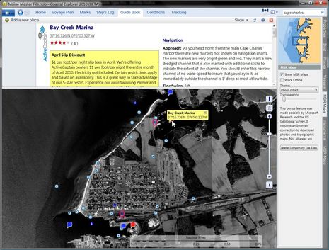 As you can tell from the Properties box lower right on the screen below, NOAA just updated this chart last week, and yet CE has it on my machine already, gratis. But, geez, why did NOAA decide to add the town’s channel buoys as if they were numbered nuns and cans when in fact they are just plain red and green balls? They are also set in straight lines along the channel that’s clearly defined by the magenta Special Anchorage areas, except (check top image) NOAA’s ENC for Camden has the north Anchorage line messed up. These mistakes are not exactly dangerous, but are a good example of why it’s great to be able to share information easily and widely. The explanatory mark I created is already live at Active Captain, and it should sync onto CE any moment now. How cool is that!
There are many more new CE and AC features to discuss, but whereas I’m blowing my own horn this week, I’m proud to point out that I was quick to spot the developers involved as special talents, profiling Brad Christian in 2004 and Jeff Siegel in one of my first Panbo entries and in Voyaging. Both have been doing exceptional work recently, and watching them work together promises to be a real pleasure.


Hey Ben, i’m going to the METS, follow me on twitter (comments in french) :
http://twitter.com/discountmarine
I stay for the day.
Hey all, Benoit is doing a great job taking TwitterPics of new electronics at METS, plus you can improve your French parsing the captions. Thanks, Benoit!
Also congratulations to FLIR whose M Series thermal cam won the Dame award for electronics, and the overall award for all categories. Navico Broadband got an electronics special mention, and Palladium’s iSiMON won the marine software Dame.
http://www.metstrade.com/home.asp
At 11:30 I’m talking electronics on ProBoat Radio. Call in with questions!
http://www.blogtalkradio.com/proboatradio
So twiddeo.com doesn’t take MOV iphone file. So I upload my video files on youtube.
Anyway, new GPSMAP 7000 are really faster ! There is a video processor for mapping.
There is also a VGA input, but nothing to use touch screen from PC, it’s a pity with windows 7 released.
(video in 6 hours…)
Can anyone figure out what would happen if the AIS600 were connected to A Furuno NavNet 3D system via the NMEA 2000 port? Would it integrate the same as a Furuno FA50?
NavNet 3D does not yet recognize NMEA 2000 AIS messages, but can use Furuno’s own FA50 via Ethernet, or any Class A, B, or receiver via NMEA 0183. Raymarine has yet taught any of its MFDs to understand NMEA 2000 AIS either, and it makes a Class B NMEA 2000 transponder.
So Garmin GPSMAP 7015 with G Motion
http://www.youtube.com/watch?v=ArQ3tpSA5xs
VGA input?I wish this guys would speed up a bit.
wheres the HDMI input?
my new macbook can output vga but thats a downgrade.
all these MFD munufactures should consider hdmi and usb inputs.
Ben,
I’m at a Furuno Navnet 3D Training Seminar at the Furuno Denton MD office this week.
The Furuno product guys have brought up this thread and questioned the advantage of NMEA2000 AIS Data over direct NMEA0183 when their systems will automatically convert the AIS data and pass it over Ethernet at 100 Megabits/second vs. 250 Kilobits/second for NMEA2000. (According to them, the existing Ethernet network has 400 times more bandwidth and can be easily scaled to 4000 times higher in the future). They say that Raymarine has the same capability vs. soaking up a relatively large chunk of NMEA2000 Bandwidth with AIS data that is only needed by the main navigation displays?
They also say that it is much easier to push AIS data and all other navigation data to onboard PCs via Ethernet either wired or wirelessly instead of having to purchase individual NMEA2000 Gateway Hardware for each PC via USB.
My question is what is the advantage of NMEA2000 over NMEA0183 AIS Data Distribution considering AIS data only needs to go to a few select displays on the vessel for monitoring/Alarm purposes? Their point seems valid to me as a technician responsible for installing this stuff on a variety of vessels.
Thanks, Technician. I got half way through a long reply but realized it’s worthy of a separate entry and discussion. Look for it later today.
I always thought of NMEA-2000 as being right sized for AIS data.
Garmin is not only running AIS, but also XM Weather data, over a NMEA 2000 backbone. The latter makes me a little nervous, but I dare guess that Garmin engineers checked the bandwidth math before making all that possible.
For the raw data (the weather data is on the order of magnitude of a compressed audio channel on Sirius) NMEA-2000 would be just fine but for a charplotter that is looking at a network attached peripheral to uncompress, process, and buffer the weather data & images such as time slices of doppler radar you would think ethernet would be a better choice between the peripheral and the chartplotter to support scrolling a weather map or paging thru time slices of doppler to track a cells movement.
I understand ScanStrut is announcing a new ScanPod tomorrow, check it out and report please.
Ben have you been able to verify my findings on the MMSI entry tab that eliminated my Class B self alarming due to my Navionics NMEA2OOO AIS Class B transponder?
I have a few comments on the GXM-51 SIRIUS weather over N2K.
Bill Lentz
Yup, just did this morning.
The 5212 runs fine with the Raymarine AIS 500 over NMEA 2000, but when I switched to the Simrad AI50, I got a collision danger message on my own boat. Until I entered my MMSI into the AIS review page. Then no problem.
I think Raymarine programmed its N2K AIS output properly so “own boat” is recognized without problem, but Garmin went and added a feature to help out customers like you who are using Navico (Navico, Bill, not Navionics!!) gear that does it a different way. Darn big of Garmin, I think, especially as they’re coming out with their own Class B that will probably work fine without the MMSI input.
My network has visually slowed since adding all my NMEA2000 devices. I will list devices and the protocol they use. I have noticed map redraws are getting slow even pushing status buttons seem to take a second push perhaps I am just impatient.
Here is my network and components.
Plotters Garmin
4212, 4210 & 3205 all use the Garmin network & NMEA0183 & NMEA2000.
GPS-17X GPS receiver NMEA2000
GDS-22 uses the Garmin network
GMR-18HD uses the Garmin network
KVH1000 position sensor NEMA0183
Navionics NAIS300L Class B transponder NMEA2000
(2) Garmin VHF200’s with 1 remote RAM mike both on NMEA2000.
GMI-10 disply NEMA2000.
GWS-10 wind sensor
GFS-10 fuel sensors(3)
Intelliducer NEMA2000
Bill Lentz
I’ll be at METS tomorrow as it is right on my doorstep (well, 40 minute drive). Any requests as to what I should report on?
So far it’s:
– Garmin 7000
– Scanstrut Scanpod
Anything else?
Any new announcements on NMEA-2000 sensors, like Airmar & Maretron ?
Any new announcements on weather, either XM, Sirius, Clearpoint, or others ? Especially products that get a much better wind forecast and gets it onto your boat ?
I would also be interested to learn if Navico brand companys are still promoting less radar exposure as the principal benefit of BR24.
Dan,
All weather solutions you mention are US only so I doubt that they’ll be out in force. But I’ll keep my out for them or any others promoting weather capabilities.
I know that Airmar and Maretron are both there, so I’ll give them a visit as well.
In the mean time I have been reading up myself as well, so I will also check out:
– Mastervolt: GPX5, a combined inverter/charger/generator.
– Mastervolt: NMEA2000 to Masterbus bridge.
Bill, that’s a Nautico NAIS300L you have, not Navionics. Two very different companies. I’ve corrected your comments before, but now I’m putting my foot down! Please write Nautico 100 times on the blackboard 😉
I don’t know what’s up on your network, but doubt it’s the NMEA 2000 sensors. I’m running a lot more N2K nodes without any noticeable effect on the 5212, which also has a GMR 24HD attached via Ethernet (but no other MFDs or Ethernet devices, and no NMEA 0183).
Kees, I’m delighted that you’re going to the RAI, and if you’d like a guest entry for your observations, you’ve got it.
I too am interested in the Mastervolt stuff, and have this question about the GPX5: “What is the advantage of housing the inverter and generator in the same sound proof casing?” (It looks to me like the inverter has an unusual number of cooling fans, and I wonder if that isn’t because it’s stuck in a case with a generator 😉
Other points of interest:
Benoit’s twitter feed includes a photo of an Icom IC-MA500TR Class B Transponder, which I’ve never been told about, and which yields zero Google results. What’s up with that?
Furuno seems to showing a new GP33 stand alone GPS unit, Airmar’s got something (my French fails me), and Tacktick has expanded its economy line.
Plus I’ve heard a rumor that there may be some announcement tomorrow about the long-rumored Garmin/Raymarine combination. I’ll actually be on Gizmo with a couple of Raymarine product guys tomorrow, trying an E Wide, but the way these publically traded corporation things work, you may know before they do. Please report!
Hmmm…looks like another wrong rumor, but there is Raymarine financial news, not good:
http://bit.ly/2lTTjv
Raymarine guys en route say the good news, not in that report, is that the banks have extended the covenants because they’re confident the situation will be resolved positively.
I’m off to try an E-Widescreen on Gizmo. Beautiful day in Maine.
Dan, Navico has never promoted less radar exposure as a benefit, only that the lack of harmful radiation allows the radome to be mounted anywhere. And Navico has consistently promoted vastly superior short range navigation and collision avoidance as ‘the primary benefit’.
I choose my words poorly, call me (follow the link associated to my name, my telephone number is on the bottom right of the web page), let me apologize in 1 on 1.
Hi, Ben,m I was at METS yesterday (wednesday). I saw the ICOM IC-MA500TR Class B Transponder. The ICOM guy on the stand didnt know anything about it! and said its was a preproduction model and the software functionality was fully defined. Launch expected next march. Its has a mono screen and a number of keys and can show a ” radar” like presentation of the AIS targets , like the NASA one. Its in a package very similar to the first ICOM DSC controllers.
dave
Ben thank you for the correction. In my haste to get information out I don’t check what my fingers are typing. I am glad the AIS alarming worked as I had reported. Even though I wrote the wrong unit name for this I appologize to all.
Ben on a side note the firmaware upgrade I mentioned (months ago) on someone’s WiFi system worked well huh? I was speaking to Richard today.
I am currently working with Richard, their manufacture and a carrier on something that might bring real speed to mariners in the right areas that have WiFi on their boats with no upgrade needed on the boat. Plus only the marina will have to deal with the service provider but to many semi rural providers they may get between cable and T-1 like performance and not the latentcy you see with using the various satellite based providers (Hughes.Net or Blue Sky). It will give that Access Point connected over the air to a WiFi enabled device the performance not normally seen and it will not kill the WiFi service providers.
Thank you for correcting my mistake on the Nautico (100 times written already) AIS NMEA2000 transponder but also verifying the fix is in! Although I will be replacing it with the Garmin AIS-600 once released.
I will be moving to coastal North Carolina soon and to be frank I can’t wait to get out of New Jersey and have 3 marinas within 1 minute walking distance of the new property home my wife and I are purchasing. Boating year round appeals to me. The same with continued testing.
Bill Lentz
Ben one more comment I am sure there are lots of guys like me that would pay almost anything to be able to read System View data from Mercruiser/Cummings on the NMEA2000 buss. I really do not understand Brunswick on this. Even if they built the module and charged a premium for it. I have some other devices reading NMEA0183 on my mostly Garmin device network the GPS input to the System View 5000 displays and an output to my Furuno NAVTEX 300 receiver.
Perhaps this weekend I will break out my Maretron N2K tester and see what it says about the NMEA2000 network in my boat.
Bill Lentz
The fix is only partly in, Bill! I watched a ship go up the Bay yesterday with both the Garmin 5212 and Raymarine C Widescreen, both connected to the same Ray AIS500. My antenna is not great and I’m way up the harbor, so reception was a little marginal.
The Garmin blasted me with Lost Target alarms maybe 20 times in half an hour, while the Raymarine never made a peep. In fact, I later depowered the AIS transponder, and the Raymarine kept showing targets for at least five minutes. I think they both have their “lost” timing off, in opposite directions, and that ALL MFDs should let a user turn off audible lost AIS and MARPA alarms completely.
As far as losing targets I haven’t had enough time to tell yet if there is improvement. I still believe in the stand alone AIS antenna and not some mobile base loaded stainless whip that really was designed for mounting on a automobile with a ground plane. I use the specific narrow band AIS 4′ Digital antenna high on the hardtop. Even when I get the Garmin AIS-600 it will be on it’s own dedicated AIS antenna with a 50 ohm load in the VHF transceiver port. Since I just got back to the boat I’ll let you know what is happening here with the lost target alarming. My false alarming is now gone. I am still unable to read the Class B AIS targets ship’s name. Only Class A AIS targets show the vessel name. All show the vessels MMSI.
Bill Lentz
Ben I have an idea I have a spare ACR AIS B transponder I will run it into a 20db tap then a (0-110db) variable attenuator then into a dumy load. It has a different MMSI than mine since the signal will not really exit my vessel and I can control the level down to -100dbm I will see what happens if the target drops out or at what level it drops out (I can do this with a simple path loss equation even in feet. It suspect it could be as simple as your AIS antenna and or its switching antenna circuit is causing the drops or loss of signal. Or perhaps (nothing new) I am not understanding the problem. On my 4210 & 4212 I can show the MARPA or AIS targets with no audio alarm unless I activate the target? If I am not understanding the problem which to me is either one of 2 problems your antenna or switching antenna circuit is not up to a task or the other AIS target is not transmitting when it should be or the proper intervals. I guess a possible third problem could be firmware/software issues. Please correct me if I totally misunderstand the problem. Since I have no AIS/VHF transciever single antenna combiner/switcher I can not measure the insertion loss of the device at each port compared to the antenna port.
Bill
I think you’re making the problem pretty complicated, Bill. I had two MFDs listening to the same AIS receiver. One gave me Lost AIS Target alarms much too frequently, in my opinion, and the other is not responsive enough to lost signals.
So it really didn’t have to do with the signal, which was probably marginal, but has a lot to do with how each display times the reception of target dynamic data — which can vary from like 2 seconds to 3 minutes without even figuring lost signals — and decides when a target is truly lost.
But the big thing is that I want to be able to turn AIS and MARPA lost target audio alarms off altogether whenever I want, just like Garmin now let’s me turn off collision alarms. I’m a big boy, and really don’t like beeping when it’s not useful. Interestingly, my Raymarine visitors yesterday told me they’re getting complaints about lost target audio alarms too.
Funny I am not having any alarm beeping Ben on the Garmin plotters but I am not activating the target is this why? I am just trying to help figure out the problem. I’m an RF guy not a firmware/software guy!
Bill
Bill, are you actually losing targets? If you’re zoomed out enough you’ll see AIS target icons get a cross through them as leave your range. I’m not sure if the graphic or audible alarm has to do with activation.
Ben; I know the X through the vessel means the AIS has not received the vessels data for period of time. I have no idea what that period should be. However I noticed during the summer I would and could track vessels up to 80 miles away when tropo ducting was happening. I didn’t seem to lose many targets then (running 5.3). This is why I am thinking it is a CNR or plain old not enough RSSI and the vessel target times out as it should? I agree that zoomed out the chances of losing the target increase with limited VHF radio range. I am not in a big AIS use area there is a dredging barge that has been on the plotter all weekend he is about 9 miles north in Barnegat Bay near the ICW. I also know when I was self alarming I don’t remember losing my vessel as a target.
Bill Lentz
Bill,
FYI, Mercury has finally come around with the N2K/Smartcraft issue. Page 28 of “Marine Electronics” (The NMEA magazine) features a Smartcraft dash gauge that will output N2k. The headline on the ad is “Mercury Gateway: Plays Nice with NMEA 2000”
No info as to when it will be out though….
Mercury Gateway:
http://northamerica.mercurymarine.com/_media/pdfs/smartcraft/components/NMEA-Gateway-sell-sheet.pdf
That’s a terrific catch, Aaron. Thanks! I wonder if Mercury hasn’t made a big deal about it because they said they were going to do this 8 years ago!
http://findarticles.com/p/articles/mi_hb5263/is_200108/ai_n20409121/
At any rate, this is excellent news for NMEA 2000 in general and any boater with a reasonably new Mercury or Cummings engine.
Here’s another sell sheet with listings of which engines output what data:
http://northamerica.mercurymarine.com/_media/pdfs/smartcraft/components/MercMonitor-sell-sheet.pdf
Glen E at the Hull Truth has already installed a prototype and is pleased:
http://www.thehulltruth.com/marine-electronics-forum/247060-new-merc-nmea-2000-install-first-looks.html
(Funny, those guys don’t seem to have heard that NMEA 2000 is obsolete, soon to be replaced by Ethernet 😉
Ben, you are taking this way too personally. You already have everyone convinced that N2K is a good thing — and it’s even conceivable that it would have died without your support. We want it. But that doesn’t mean that we need to worship it or believe that it is the best of all possible worlds.
Ethernet is not going to replace N2K any time soon, but it will handle radar, sonar, video, and other things that N2K won’t.
I wonder why it took Mercury 8 years to deliver on their N2K promise?
Sorry, Norse, you may be right. I do bridle when watching Panbo become a source of misinformation (plus I have the flu!).
I have played N2K evangelist but I sure didn’t save it. It works well, especially when the manufacturers get fully behind it. Plus I never said it was the only networking for boats, and neither did the NMEA. Ethernet was always conceived as the right replacement for broadband analog radar and sonar cables, and that has come to pass.
What has not come to pass is Ethernet being used for the narrow band tasks that N2K does well, not even a little bit. Nonetheless the Ethernet-good-CanBus-obsolete meme is very much alive. It’s a curious phenomenon, having much more to do with the computer world than the boat world, I think.
Ben and all; thank you for the SmartCraft NMEA2000 links. I will install a multi-engine version (as soon as I can get my hands on the kit)and let you all know how it performs on my Garmin plotters.
Bill Lentz
There’s one Garmin VHF/AIS model missing still. The VHF 300 AIS combines N2K, Class D VHF, and receive-only AIS. Too bad about that last part. Where’s the model with full Class B AIS? Like in the AIS 600, but with the Class D VHF too.
The Garmin 600 list price is 99 cents more than the Raymarine AIS 500 but adds N2K. Good move.
The Garmin 600 list price is about $400 more than the Navico NAIS 300, but adds the ability to use just one VHF antenna. Sounds like a lot, but it may be worth it.
Norse, maybe I’ve been unclear but the Raymarine AIS500 definitely outputs NMEA2000 (a.k.a. SeaTalkNG). The patch cable to regular N2K unfortunately has to be made up, because the AIS500 has a male pigtail instead of a normal female plug, but other than that, the specs are very close to the Garmin 600.
I’m not sure why you’d want a all-in-one where combining a VHF 200 and AIS 600 on a plug and play network gets you all the features, especially if you also have a Garmin MFD on the same network. (I expect, at least hope, that those features, like making DSC calls from an MFD will become interoperable).
Raymarine is the one being unclear. I just looked again at the website you linked above. The overview page only mentions NMEA 0183, not SeaTalkNG, and certainly not NMEA 2000. However, in the downloads section there is a mention of SeaTalkNG and the product brochure does mention it. I overlooked that.
Garmin should upgrade their 300 AIS to Class B.
I am particularly interested in black box units because of space limitations. It makes more sense to have them in some dry, out of the way place and just put small control units in the cockpit. If the control unit is not in the cockpit it is not useful to me. The only problem is that black box units are always way more expensive.
I don’t care if the AIS and VHF are both in one box or not, although it would seem to make sense since they are related and they do interact.
Yeah, well Raymarine may be downplaying the STng/N2K output because none of its STng plotters yet understand AIS N2K messages. That’s coming via software update, date unknown. Plus the AIS500 needs to be updated to send out the standard Class B static data message because the NMEA was tardy about writing it. So the AIS500 on Gizmo is delivering N2K AIS to Simrad NXE and Garmin 5212 (minus Class B static data) and to E Wide via NMEA 0183 (all data).
Yes, there have been some glitches for early adopters of AIS over N2K, but please don’t extrapolate that into more than fairly typical early adopter glitches.
I notice that Garmin has new GPSMAP 7000 site up:
http://www8.garmin.com/buzz/gpsmap7000/
Hi Ben,
Yes that was added yesterday and it’s presentation is great. No problems with installing the add on as well. There are other great new things in the works as well on the 2010 Beta including Navtex and just loads of other stuff.
I’m proud to be a member of the beta test team for what is going to be a Stunning Nav Program.
Steve.
I agree, Steve. CE is hitting a new level (ActiveCaptain is too). And maybe what’s most interesting is what we can’t see. As I understand it, the architecture of CE 2010 is quite different in the sense that the UI is separate and can be modified without affecting the core functionality. What that actually means in the market place I don’t know yet, but it seems rich in possibilities.
Incidentally, I believe the 2010 beta software is available to anyone who currently owns a Coastal Explorer license, and it seems pretty stable at this point, at least for me. I had a little trouble at first getting used to the activity window on top, but I’m over that now. It works.
I’m not yet sure how comfortable I am using community generated “local knowledge” such as is found in sources such as ActiveCaptain. Contact #’s and such I am fine with, but info on anchorages, protection, holding, etc. can be very subjective and based on a host of variables the reader has no way of gauging. I have been around the web enough to value my printed version of the Tafts/Rindlaub “A Cruising Guide to the Maine Coast,” even more. These are long-standing, edited guides whose authors stake their reputation on accuracy and the safety of the people using them. Community generated info offers no comparable standards. It’s the Wikipedia conundrum: it may offer a reasonable quick intro, but make sure you have a way to check your facts. I’ve seen “local knowledge” posted in online cruising guides on anchorages I know very well (not in ActiveCaptain, per say) that is just plan inaccurate, dangerous, or even, sometimes, clearly base on a poster’s personal agenda. It is the simple reality of the wild world wide web.
Right you are, Collin, and I’m glad you used the Taft/Rindlaub book as an example. I too think it’s one of the best cruising guides around. I knew Hank when he was creating the original, and I’ve met Curtis, who’s tried valiantly to keep the book up to date:
http://mainecoastguide.com/intro/intro.html
But I’ve also covered the same coast myself for a decade, though in an entirely eccentric and incomplete fashion:
http://www.maineboats.com/ben-ellison
And I can tell you with some certainty that it’s impossible for any one human, or company, to deeply explore, or keep up with, all the features along even a single state’s coast (ours is particularly long and varied).
Which is why I’m so pleased that CE is offering multiple sources of information in an easily searched and viewed form. I think I’ll make the best cruising choices if I have access to both the pros and the amateurs out in the field.
By the way, ActiveCaptain has a clever system for validating user input without bogging themselves, and the site, down. As I understand it, whatever a new user writes is quality checked before it’s published, but once a user has contributed x amount of apparently valid information, his or her data goes up instantly. That’s one reason they insist on user registration.
Ben,
I’m hoping that Brad will be able to roll out this AC collaboration to other similar Websites throughout the world. Ive gained permission to interface with VisitMyHarbour.com which is a great PHP site in the UK with detailed pilotage, charts, history, facilities and just about everything the mariner needs to know, but I am having to put in each harbour entry and link in manually on CE.net at the present time, athough I’m getting there slowly. Ive got the Solent to do next which should keep me busy for a week or two.
Yes any present CE users can join in the beta group if they feel they want to, more the merrier and solves problems quicker I’m sure.
Nice satellite shot of CE..unfortunately we dont have that in UK but I can always flip to google earth if need be.
Regards
Steve.
I think the question of user-contributed data is an interesting one. I’m not sure I completely see the parallels to Wikipedia and it’s negative impression that has generated some bad press over the years. On one hand, Wikipedia offers a single view of a subject. Look up John F Kennedy and there is a single article edited together with the input of many people. There might be dissenting views within the article but you completely lose each particular person’s perspective because it’s been edited and combined.
On the other hand, ActiveCaptain keeps the individual “opinion” reviews separate and identifiable. You get to see a particular person’s opinion in whole. We often see one review talking about how wonderful an anchorage is in the Spring where another tells how it is filled with crab pots in the Fall. Each review also has a number of points the captain has accumulated to give some idea about the amount they have contributed and possibly their credibility.
Anchorages are special things. One person’s view and experience might be very different than another. Having all views is very valuable to making your own decision about picking a place for the night. No one should ever just read a couple of reviews and blindly drop their anchor on the marked spot, however. Every mariner has a responsibility of checking charts, prevailing conditions, and their own boat’s capabilities/draft, etc. before they should ever drop their hook.
While it’s not completely the same, I’d prefer to read a dozen book reviews in Amazon than one “professional’s” review in the NY Times. The world gives a much better view when looked at through the eyes of many people.
Jeffrey Siegel
ActiveCaptain.com
A good, if personal, example of Jeff’s point is his and my very different reviews of Wayfarer Marine in Camden. I just updated my review this morning, because I’m a regular yard customer now, and our experiences there are now even more opposite. Gizmo was launched yesterday and I’m pleased about how the whole storage, repair, and spring prep process went.
Incidentally, my review change — done at the ActiveCaptain site because CE doesn’t yet have edit functions — showed up in CE in less than an hour. This didn’t seem happen with my Camden new chart note yesterday, but I’ve learned that you have to zoom out and in to get CE to refresh its cache. I replaced the original bottom image above with one showing my Hazard marker.
I do wish I could edit the Hazard entry like I did my review because I wrote the original in Word and several characters — a dash, and two quotation marks — became gibberish in translation. But it will still work. The new chart just came out a few days, but anyone using CE, MaxSea TimeZero, or the ActiveCaptain site will get a little more info on all those bouys NOAA added.
By the way, it’s not clear in my screen shots, but all those CE POI markers go away when the user selects “Home” or any of the other top tabs besides “Guide Book”.
The Hazard details can easily be edited on the web site. I know it isn’t optimal to have to go to another place and it’s temporary until editing is put into CE. Ben, if there’s anything about the text that you don’t like, it’ll really only take 30 seconds to fix it.
Here’s a quick link to the marker:
http://activecaptain.com/X.php?lat=44.207947&lon=-69.053515&t=n&z=15
or
http://tinyurl.com/y3ewb8a
Now that I figured out how to edit Hazard marks, mine is fixed, and it appeared in CE quickly. All is well.
Collin makes an interesting point. To see what the reviews were like in several boating areas which I am very familiar with, I spent a couple of hours reviewing the information on Active Captain.
Most of the reviews were very accurate. The only area which I might disagree were in rating of restraunts–but these often change management. Many of the reviewers were people I was familar with from lists like Trawlers and Trawlering, or Seven Seas Cruising Association.
What was surprising to me was how many of the posts on the Gulf Coast were people whose home base was from some distance. In Washington State and British Columbia most of the reviews were local, but as I worked my way to Alaska on AC, there were very few reviews of any sort. Will Active Captain replace guide books?–not yet, but it is certainly is a great suppliment, and I would not hesitate to use it anywhere in the Coastal Waters of the US and Canada. Jeff and Karen have done a great service for the boating community.