
A World Magnetic Model reminder, courtesy Maretron
Is your boat’s World Magnetic Model up to date? Does it matter? It may be a sign of Miami new product overload (here and here) that I got intrigued with this subject yesterday, but it was actually a Maretron press release (pdf here) that led the way. The company is proud that their latest GPS200 now outputs magnetic compass variation based on the latest WMM2010, and that a firmware update will bring the same precision to their existing GPS receivers. Heck, I thought GPS units just got variation from the satellites, and was reminded how much we take compass technology for granted…
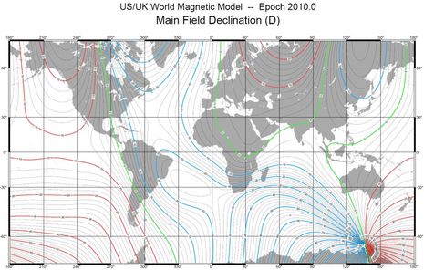
In fact, it’s mind boggling to contemplate the sensuous diagram above (available as a much bigger PDF at the multinational agency which maintains the Model). I’ve understood since my earliest days as a chart and compass navigator that Variation — the difference between Magnetic North and True North — varys according to where you are on the planet and that the variation changes slightly over time. Where I live, if you steer 90 degrees by the compass, you’re actually headed 73 degrees True because, according to the chart rose, the Variation was West 17 degrees 30 seconds in 2001 and it decreases 3 seconds a year. (Which, along with the prevailing southwesterly winds, is why the northeast trending Maine coast is called Down East.) Only obsessives bother with Variation corrections, though, because they’re so minute, and once you get past the add/subtract confusion (Can Dead Men Vote Twice At Elections, etc.), you’re pretty much good to go.
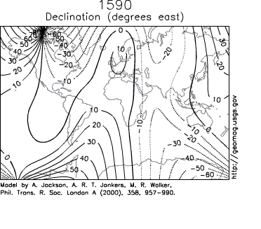
But consider our forefathers, who were so much more dependent on the magnetic compass for crossing large bodies of water. Variation charts, like Halley’s 1702 edition below (when Maine V was about W 12 degrees), must have entailed all sorts of difficult onboard celestial observations and pre-computer calculations. And did they get it right? The first sentence of the WMM Wiki entry on the math loses me! And as you can see from these illustrations Variation can vary in pretty extreme ways, especially if you wander close to the magnetic poles, and there are other factors involved, like magnetic intensity and dip. Did you know that good compasses are set up for the hemisphere you boat in? The whole magnetic phenomenon is deeply (and beautifully) complex, which is why scientists only feel comfortable predicting Variation for five years at a time.
 So here’s what I wonder: Was there a period long ago when old salts were as skepitical of new fangled compasses as some are today about GPS and electronic charting? “Hey, kid, get your head out that binnacle and pay attention to the birds and wave trains!” Then later did some skippers freak out when their compass went blooey for a few minutes due to a local magnetic disturbance or poorly engineered gimbeling? I’ve got a free Panbo subscription for any reader who can document such behavior. (Also note that every single person who fills out the marine electronics survey also gets a free subscription 😉


The Maretron GPS200, by the way, is one of the new breed that can update (not just output) position, COG, SOG, etc. five times a second, which might make a fast boat plot more smoothly. Its manual also goes into more detail on matters like the Variation Model than others I’ve seen.
I have an older GPS100 and I’ll try to note the Variation difference when I update it from the 2005 WWM to the 2010. As far as I know, all other GPS receivers are using the 2005 model, because it’s only updated every 5 years. But I suspect that the differences are pretty small in most places.
So where is Variation used in your electronics system? I’m not positive but I’d guess:
* To calculate wind direction relative to ground (which some call True Wind).
* To draw a boat’s heading line on an electronic chart.
* As part of the calculations an autopilot uses to steer accurately toward a waypoint.
Yeah, and we are about overdue for a flip of the magnetic poles, N becomes S – the last one was roughly 780,000 years ago… Now, that should be fun when the core starts precessing (wobbling) then flips over – and confusing for the birds ..
Maybe Fat Al can blame it on global warming and sell you magnetite credits…
denny-o
Well, it turns out that there’s more to this story than I originally understood. Apparently the Maretron GPS100 and GPS200 were conservatively set up to stop outputting any Variation once the 2005 five year model ran out on 12/31/2009. The 2.2 firmware update contained in N2KAnalyzer ver 1.4.13 fixes the problem easily, but there may well be Maretron GPS users out there wondering where the heck their True Heading went to. Therefore I’m adding this issue to the Garmin and Raymarine bugs posted yesterday:
https://panbo.com/forum/electronics/bug-alerts/
So I couldn’t compare WMM2005 and WMM2010 on the GPS100, but the difference between WMM2010 on the GPS100 and WMM2005 on an Airmar PB200 in mid-coast Maine is only about .1 degree.
Ben,
This is an interesting post. I’ve been wondering about the WMM since I saw the Maretron release. Though I have to confess that given that a mechanical compass can easily swing back and forth through twenty degrees when in heavy seas it’s not clear there’s much to worry about. But I love that Maretron touted a bug fix as a feature. 🙂
Regarding heading output frequency, do you know what rate other modern GPSs like the Garmin 17x NMEA 2000 version output at?
/afb
Hi Adam,
Both the new Lowrance LGC-4000 and Simrad GS-15 are also true 5 Hz update GPS receivers, although they are 16 channel to Maretron’s 32. I can’t find the update rate for the Garmin 17x N2K, and it’s ‘only’ 12 channel, but I’ve used one a fair bit and it seems very responsive and quick to acquire a fix (even when buried under deck). My sense is that all these new receivers are quite good.
Funny thing about the Simrad GS-15, which I suspect is the Lowrance 4000 relabeled: The receiver itself has a standard DeviceNet/NMEA 2000 port, but it comes with a patch cable to SimNet. It’s the first SimNet product I’ve used where I didn’t need a patch cable in the other direction 😉
Ben, others, if you have an Actisense NGT-1 it is easy to see how often a PGN is updated by running the Actisense NMEA reader program. It shows a list of different PGNs and senders as wel as when the message was last received and what the interval to the previous message was.
E.g. on a 5 Hz update you expect an interval of 0.2.
To check that the positions are really distinct you’d have to log data whilst moving the GPS receiver. Easy to do on the boat, a little harder to do in the lab!
Fugawi Marine ENC, Fugawi Global Navigator, Navionics HotMaps Explorer and Geonav MapMaster (all of which are manufactured by Fugawi/Northport Systems) were all updated to the 2010 magnetic model earlier this month. Customers of version 4.5.x can update for free at http://www.fugawi.com/web/support/updates_index.htm
Is this really feature news or rather dumb software bug announcement from Maretron??
The average change in variation with this new “2010 Magnetic Model” is about 0.1 degrees on our planet!!! This equals a 0.02% change in COG values reported from a GPS.
Big Deal!!!
Thanks, Kees, I hadn’t noticed that “Interval” column in the Actisense Reader. But that is transmission rate, not necessarily update rate. I just checked out the Maretron GPS100 and Garmin GPS 17x and they both show Rapid Position rates of about 10 Hz and Rapid COG/SOG of 4 Hz.
Strangely enough the Garmin does not seem to output the Variation PGN at all, but the 5212 does if its on. Seems like everyone does things just a wee bit differently.
Ben, what are the implications of the 17x not outputting Variation if the unit is *not* used with a Garmin plotter? Could there be a situation in which magnetic bearing would not be accessible from instruments on the N2K bus?
My brain hurts trying to figure that out, Adam! But I did confirm with Garmin that the GPS 17x NMEA 2000 does not output PGN 127258, Magnetic Variation. I’ll experiment when I have a chance, but maybe someone else out there can tell us what might happen if its used without a Garmin MFD or some other Variation source.
Ben, I can probably answer that myself. I just got a giant shipment of NN3D stuff today, and I have a 17x. Not sure I have enough N2K cables and junk to get them hooked up but I’ll give it a shot and report back.
I did some testing myself, Adam, and the results were somewhat disconcerting. In fact, they’re so complicated that I’ll do a whole entry on the subject eventually. Everyone should be careful, though; I saw some instances where MFDs or instrument displays that seemed to be happily showing True Heading were actually showing Magnetic Heading, and it’s possible that some systems just started doing this on Jan. 1, when the magnetic model changed.
I have some experience in this and will try to comment the different aspects. I have a Maretron-based N2K system including their MFD,Log,Wind,Compass and Wind sensor. I wasn’t impressed with the outdated Maretron GPS100 and partially based on Ben’s testing i got the Garmin 17x GPS instead.
Now, some basics;
True heading is used for mainly 3 purposes;
– To correctly extend a heading line on a charting system
– To correlate radar and chart information, in radar over- or underlays, or to enable chart plotting of ARPA/MARPA targets.
– To enable an AIS transponder to transmit ships heading (both Class A and B can do this)
True heading can be obtained by different sensors; Gyro and GPS compasses deliver true heading without the need for variation (but instead needs it to calculate magnetic heading). But, most smaller ships and leisure boats use some sort of magnetic compass (fluxgate-based), and needs a source of variation to calculate true heading.
So, in my system the Maretron SSC200 (Solid State Compass) needs to have variation by one of three means; 1. Over the N2K bus (from a GPS) 2. from the NMEA0183 connection (also from a GPS), or, 3. Manually entered by using the setup in the MFD.
I soon discovered that the 17x does not provide any variation, and the compass correctly did not output any true heading PGNs (or HDT sentences). But, to give Garmin some slack, most consumer grade GPS don’t actually provide any variation. Looking at an RMC sentence from any basic GPS, you will probably find that the variation field is left without data.
So, for now I’m using a manual, fixed variation which is OK if you are not traveling over big distances, but otherwise is not recommended. I’m also looking into getting the new GPS200.
So, i think we should give Maretron some credit for providing a reasonably priced GPS that actually provides variation, and for keeping the variation model updated. Most mfgs take the easy way out and just omit the variation tables.
2 sidenotes;
1. All N2K GPS should transmit the position PGN 10 times per second, but most, including 17x and GPS100 only calculates a position update (resolution) once per second, and transmits the same data 10 times. The GPS200 does however calculate 5 resolutions per second and transmits identical data only 2 times for each resolution.
2. The SSC200 is av very nice product. It provides stable, fast heading for N2K and NMEA0183 outputs simultaneously, with very configurable outputs on 0183 (speed, sentences, sentence rates). It’s perfect in my system where it provides mag. and true heading to the N2K bus, but also HDT sentences at 38400 bps to my CTRX AIS transponder, which enables it to transmit my boats heading over AIS, which is very rarely used in ClassB, but possible, at least for all SRT-based transponders.
This became a very long comment, but I hope it can help others without spending the same amount of hours i did last winter!
BR /Marcus
I am a collector of old charts and would like to know where I can purchase a copy of the old variation chart. I would go great with my other unique items.
Did anybody find out if the simrad GS15 outputs variation data and what model it uses? I am going crazy trying to get my B&G H3000 to display set and tide. This is I think because I am not getting GOG magnetic into the system via an AT10 converter and my heading reference inside the H3000 (an H2000 halycion) is magnetic.
Thanks
Francisco
I just checked and the Simrad GS15 does not output PGN 127258, magnetic variation. Neither does a Garmin 17x, but the Garmin 7212 MFD outputs mag variation and so does the Simrad NSE12. Seems like Maretron and Airmar, which don’t have MFDs do output pgn 127258 from their GPS sensors.
I missed the original article, Ben, but I HAVE to say you deserve the Wordsmith Of the Year Award (the WOTY) for the line
“Hey, kid, get your head out that binnacle and pay attention to the birds and wave trains!”
This serves as warning that I intend to quote, plagiarize (with or without attribution) and purloin that entire paragraph in the future, out of respect and envy for the master.
Sorry, Sandy, but what the heck are talking about? I wrote that? What article? Were you staring at birds and got a crook in your neck ;-?
Thanks Ben,
Much appreciated
Fchurtic
Too late, Ben. It’s done, and the angry Iron Men (of Wooden Ship fame) are massing at your gates, brandishing brass sextants and tightly rolled charts…
Such are the wages of notoriety.
Good grief, I did write that, right in this entry too. (The “original article” thing put me off, or I’m off already.)
At any rate, I figured out how you used the quote, Sandy, and I like it a lot:
http://www.cruisersforum.com/forums/f131/us-turns-off-gps-in-florida-what-is-your-backup-53791-7.html