
Garmin Homeport, excellent but revealing
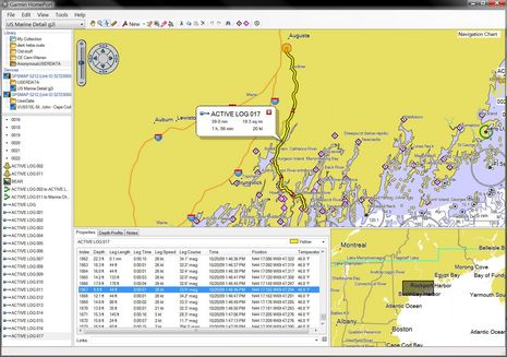
I can’t imagine why anyone with a Garmin plotter, a Windows PC, and a bit of ability to use both wouldn’t find Garmin Homeport more than worth the $30 charge. I was able to easily copy the 5212’s embedded charts — plus the mess of tracks, routes, and waypoints I put on it last season — and then review/manage all on my home computer. I stowed away some memorable tracks, quickly cleaned up some extraneous waypoints (careful with that track-to-route feature), polished some favorite routes, and then overwrote the user data on the 5212 with a much more useful set. But today’s look at some deeper Homeport features gets the benefit of a friend’s embarrassing navigation error. Click to enlarge the screen above and I’ll explain after the break…
We’ll call him Anon so the Google won’t forever pin this very uncharacteristic mistake to his real name. At upper left on the screen you can see that I’ve opened the user file that we downloaded off his Garmin and that I imported into my Homeport Library. Thus all the data in the lower left window is his. Note that I’ve also opened the 5212 base map from the SD card you can see under Devices (I also have the Vision SD card in the PC, and can switch to that added cartography detail if desired). At any rate, I’ve clicked on Anon’s last automatically made Active Log (track) and Homeport has zoomed out to show part of a neat trip he took down and back up the Kennebec and Sasanoa Rivers from the launch ramp in Hallowell. Clicking on Active Log #16 would show the 25 nm he’d run down river before lunching in Bath.
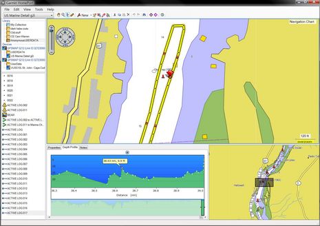
So Anon drove some 64 nm of complex river (the skinny Sasanoa is famous for its whirlpools!), and his Garmin tracked every bit of it in some detail, as you can see in the bottom middle window. Methinks it was all that navigational focus at speed that largely accounts for what went wrong at track point #1,867, when Anon was within sight of the launch ramp and running a little bit further up river to burn the gas out his outboard. Clicking once on that particular track point got Homeport to put that orange circle mark on the chart spot, clicking twice zoomed into the tragic image below.
I was with Anon when he first saw this track zoomed in on his plotter and then even better detailed on my big PC screen. “Damn!” is what he said. After running over the apparently sunken “crib” he’d had to limp the boat back to the ramp with a badly damaged lower unit and hadn’t investigated the track detail. In fact, though he took responsibility in the proper captain fashion, he kinda sorta thought the Garmin had misguided him about the “Obs rep” and the correct side to leave that bouy 68a. But the log says different and actually comparing this chart to several others indicates that Garmin may have done the best job of representing the underlying NOAA data for this particular spot. Better even than the NOAA, ENC in my opinion, but I’ll detail that in a future entry.
As for Homeport, note how it’s able to profile the log’s collected depth soundings, even zoom in on individual points and pinpoint them on the charted track. Which is pretty darn cool, though there is some discrepancy between the shallowest point marked and the actual location and depth of the crib. But, mind you, those pre-crib points were collected at 25 knots, and there may be ways to get the Garmin to record points even more frequently. (Which, incidentally are issues that will come up with data collection schemes like ARGUS.) The big story, though, is how a skipper like Anon might have used Homeport to pre run a trip like this, even route it, while sitting at home or at a down below nav station with a big screen, a mouse, and the time to really check out the chart detail available.


Ben,
Forgive me for being dense; but are you saying that Anon has an outboard powered boat that draws 9 feet at 25kts? And that this vessel is trailerable?? Is this a Macgregor or something?
What am I missing here??
No problem, and sorry I wasn’t clearer.
It’s fairly big for a trailerable boat, but otherwise normal. What he hit was just deep enough to catch his outboard lower unit but not his hull, maybe two feet. It’s pretty obvious from the track points, especially the rapid loss of speed (;-), that it was the “crib”, even though Garmin shows it as sticking above the water. There are several stone cribs in that area, left over from some industrial use, and I think they’re slowly coming apart and disappearing, which is a challenge for chart makers.
The recorded depth points apparently missed the split second when the transducer passed over the crib, which makes sense. If you look at the first screen you can see the variation in speed/distance/heading from point to point. I think they show how the Garmin tries to make rational decisions about when to record track points when in automatic mode.
When fully zoomed in, the track details and charted crib don’t add up perfectly, but I suspect it’s just a matter of GPS accuracy at 26 knots, or maybe even chart accuracy. But how often do we get to look at a situation like this in such detail?
Score one for us dinosaurs. But not really. Stuff happens (as he said after his rudder fell off 130 miles northwest of Bermuda).
This argues for a discrete CYA button, possibly on the back of the chart plotter, that scrambles the recorded data sufficiently to create an aura of plausible deniability. Sometimes the evidence is too clear!
Here is a video of the features Ben tlaked about.
http://bluewaterpirate.phanfare.com/4399275_4816250#imageID=84176472
Tom
After all the praise of this software, I bought a copy. I can indeed load tracks & routes etc from my 4208 plotter into my pc and operate on them. Cool stuff.
BUT I’ve been unable to reverse the process. I’ve used the method in the help file and the method specified by the item in the knowledge base (neither of which match what I’m seeing on the screen) without effect. No data is transferred to the plotter.
Has anybody made this work? How?
Cheers,
Peter McCorison
Peter, I had no problem either merging or overwrting HomePort created user data to a 5212. But I do recall that it took me a bit to understand how to drag and drop data to the SD card.
There is free alternative to Garmin HomePort.
I have been using MapSource to build routes on my PC to load to my GPS. The routes were useful but crude due to lack of MapSource map resolution. And building routes on the GPS is too tedious.
Now I’ve downloaded the free PolarView from Polarnavy.com to use with the free NOAA ENC charts. I can now build accurate routes quickly and easily. I could also import track histories, although I haven’t tried that.
PolarView seems to have most of capability of HomePort but eliminates the need to extract charts from your chartplotter, plus it will work with other makes.
Comments from other users?
Paul
The problem with electronic charts and gps is that they are so darned precise…
The reality is that the electronic charts are transcribed from paper charts or other surveys and you have no immediate information as to the age of that survey, whether it has been properly shape corrected to WGS84, whether positions of obstacles were proven or estimated, etc… Also, the bottom of the river/channel may have shifted sideways (very likely in fact) since the original chart was made but the obstacle will (usually) stay stubbornly in one place…
There are any number of books out there that talk about charts and the new age of electronic charts and the inherent accuracy of a chart (or very real lack thereof), but this is dry technical stuff that 99% of us ignore – until we hit something…
For instance, your spiffy new electronic chart of Bermuda has base data that comes mostly from an Admiralty chart done in the 1780’s, and not updated since… Further a vector chart can move plotted positions of objects a significant amount when the chart data is transcribed, compared to a raster scan of the original chart…
Depending on a GPS position that has 15 meters of accuracy when plotted against data from a paper chart that maybe had an accuracy of 150 meters plotted onto an unknown earth shape (well, that information was ‘known’ on the original paper chart), is a recipe for an ‘interesting day’…
denny-o
http://www.nunonavigator.com/ – Beta version released now with full version out later for monthly subscription. Have used it a couple of times now and it does what it says on the tin. I know what you mean about precise (and slow) but this solution seems to not suffer from any sluggishness; just takes a wee bit of time to download.
Garmin now has MAC version of HomePort planning and logging software: http://goo.gl/SgnQL