
SailTimer, gone iPhone & handheld
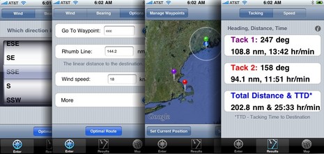
I first heard about SailTimer — a set of algorithms for calculating sailing tacks, including total distance and tacking time to destination (TTD) — back in 2006. And it did indeed become a very interesting feature of NavSim’s SailCruiser. But developer Craig Summers was not done there. His Indepth Navigation company now offers a free, and very simplified, iPhone version of SailTimer as well as the $14 app illustrated above. Frankly, even the paid app doesn’t seem as full featured as the online SailTimer demo yet — you don’t see what your calculated speed is, for instance — but I know Summers is working on it. In fact, SailTimer 2.0, with tacking lines drawn between those pins on the map, is due out this week. And then there’s the “Sailing GPS”…
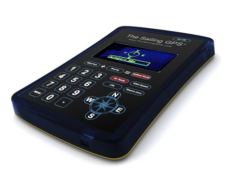
Yup, Summers has designed a handheld GPS with SailTimer math built in, as seen below. It’s due to ship soon, and apparently I’ll get to test one. In the meantime, the best way to understand the SailTimer app is via this YouTube video. And to really get into the problems surrounding traditional VMG numbers, you can read Dr. Summers article in GAM magazine, and also this Knol piece by John Navas. Whereas I’ve become something of a stink potter in my old age, I’m very curious what you blow boaters think of the SailTimer concept and implementations.


Seeing this, I just had to drop what I am doing this morning to take a look.
The GAM article is awefully long, looks like it could be summed up as
(1) most GPS units show the wrong ETA which gets progressively worse as you stay on the same tack to a destination more upwind then you can steer too. The reason is that they tend to use VMG to destination (not to be confused with VMG wind) which decreases as you stay on the same tack.
(2) most GPS’s blank out the ETA (really, I don’t experience this Raymarine and Garmin equipment)
(3) Conclusion: GPS products can’t calculate a good ETA for a sailboat (agreed)
The Knol piece is cool, I need to re-read this at the start of next season. While we (sailors) all know that VMG wind (not vmg destination) has an optimum somewhat less than pinching but around close hauled and that changes based on wind velociy, figuring it out upwind is tough and downwind is near impossible without (drum roll please) a good measure of true wind speed (relative to water).
Maybe it’s me, but I find more interest in the GPS calculators features (not convinced it works, just interested) around figuring this out for my boat and then using it in navigation, much more so then the promoted feature of getting an accurate ETA.
Putting this out as a cell phone app makes a lot of sense, now if we could just get information from my boat into the phone real time that would be sweet.
I would be curious how far summers takes the calculations, e.g. is it aware of current set/drift actual or predicted, takes into account the effects of land bending the wind, or the wind forecast for the day, etc. As the wind forecasts are really aweful, perhaps many of these variables are pointless to include unless the user can enter them and compare choices (if I continue on this next tack and the wind starts a circular shift sooner than forecast, will that hurt me ?). As good as this tack looks, am I toast after the current shifts later today?
When it comes to ETA, the current plays a really big role. I have been long awaiting the promissed ETA calculator feature in Coastal Explorer that will allow me to see how the ETA changes based on starting my leg sooner or later.
This problem has been solved by several leading sailboat navigation/racing programs at a level completely beyond anything even imagined by this application.
These solutions which are routinely used by racing sailboats take into account the observed winds & current, predicted winds & currents, the performance characteristics of the boat (polars), available sail inventory, and max/min desired operating limits. They also interface to high-resolution weather data from both government and paid commercial sources.
These solutions can also help you play the wind shifts and identify areas where you optimize your VMC.
Perhaps the best example of these solutions is Expedition (www.iexpedition.org).
Understood, Mistaken. I’ve seen Expedition in action on a blue water passage, and it was amazing. But it’s a serious program in terms of expense and learning curve, isn’t it?
Wind direction and speed rarely remain constant. They typically oscillate. Taking advantage of these shifts can result in significant improvements in velocity made to a waypoint. Simply entering a rough estimate of wind direction/speed into an iPhone app is very much an over simplification.
Bill Gladstone does a good job of explaining this in “Performance Racing Tactics” ..
http://www.gpsnavx.com/images/windshifts.jpg
Being a sailor (along the lines of Capt.Ron), what I would like to see is a response from Jeff Hummel / Coastal Explorer, whether they are working on incorporating something like this as a feature or as an optional you-pay-for upgrade. I would be very willing to spend a reasonable amount of money to have this capability work and overlayed on my CE charts and am assuming there are other sailors who would, too. I have recently signed-up for the Summers’ Sailtimer GPS unit and prepaid a $99 deposit fee a few weeks ago, to be in line for receiving a unit a a discounted price when they come off the line. It will be interesting to find out, when this GPS eventually ships.
I have used Coastal Explorer, NobelTec, and MaxSea Time Zero extensively in thousands of miles of sailing & racing – while these are each great programs primarily designed for the recreational power boater, they are not even in the same league as Expedition when it comes to sailing.
Nearly every serious racer that I know uses Expedition because of the reasons stated in my earlier post. Furthermore, given the limited market for such a program and the fundamentally different way it approaches data handling – the other applications mentioned would have to be completely re-written in order to provide what Expedition does natively.
While I haven’t used the SailTimer GPS, if it doesn’t have access to realtime high-resolution true wind speed, true wind angle, heading and boatspeed information it isn’t going to be very useful. Furthermore, there is a tremendous difference between GPS sensors and if you are serious about quality data you would not use a hand-held low-resolution unit. Most of the serious racers use survey-quality DGPS units along the likes of the SIMRAD MX421B. Units like this produce very accurate fixes at 5-10hz.
Yes Expedition is expensive ($1250 US) and is a little more difficult to learn than say NobelTec (although not much), but if you seriously need accurate sailing data, this is the most widely used solution. The only other program (at least in North America) that come close is Deckman for Windows from B&G. While it has powerful data handling capabilities, Expedition has essentially made it obsolete in all other areas.
I would however give an honorable mention to Advantage Racing Software (www.goflow.com). They have some very unique ways to graphically display optimal VMC (VMG is only useful in buoy racing with a square course) and compare tactical alternatives using predicted currents and winds.
Why does everyone seem to ignore the blackberry when designing such software?
Tim, the Blackberry has business stamped on its casing, whereas the iPhone is sexy and “everyone” wants one, has one or will soon. 🙂
Probably more detail then most want to read, but this article explains developing and distributing software for Blackberry is quite difficult…
http://www.versatilemonkey.com/story.html
To Apple’s credit they have provided a very complete development solution.
GPSNavX forgot to mention that MacENC also supports SailTimer math, which I forgot too:
http://www.macenc.com/
This seems very much like the Tacticalc I developed some 30 years ago in the UK, when the RORC did not allow people to connect any computing device to their instruments (B&G 190, from memory, were the first to allow this), and people were using Decca (European LORAN, effectively) as GPS wasn’t around then. It calculated tacking and gybing angles, bias on beats and runs, best tacking/gybing angles, and race handicap data, all on a Sharp programmable PC with 8k of RAM. Just shows there’s nothing new under the sun!
The implementation of “SailTimer” in MacENC is more sophisticated (and useful) then iPhone app or web based versions. MacENC continuously computes the optimal angle(s) to sail to a waypoint using wind speed and direction (from interfaced instruments), predicted performance polars (user editable). MacENC also plots the tacking and gybing angles on the chart.
Screenshot link
http://www.gpsnavx.com/MacENC/images/screensailtimer.png
For many years time now, more advanced (i.e expensive) applications (i.e. Maxsea, Expedition, Deckman) will do the above, plus take into account predicted weather to create an optimized route.
As a simple rule. If VMG to a waypoint on a GPS receiver is less then 1/2 speed over ground, then the other tack/gybe is favored.
The SailTimer iPhone app is now on sale for $4. Plus, here’s a good video about how it works:
http://www.youtube.com/watch?v=5O820vU9LN0&feature=player_embedded
The SailTimer app in iTunes now also includes a new Compass Heading screen.
Located with the large speed (in knots) display, it shows your current heading, and a visual slider that shows if you are inadvertently angling away from the optimal tacking route.
You can get the iTunes download link for the app ($14) here:
http://www.IndepthNavigation.com