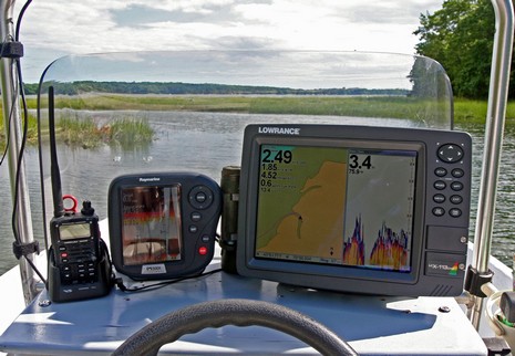
Good times: I spent most of yesterday testing electronics on Gizmo and visiting around Camden Harbor. One system I was mostly pleased with is this little wireless communications and navigation PAN (Personal Area Network), if I may apply a long name for what’s a fairly doable setup these days (bigger picture here). The Palm Centro is running ActiveCaptain Mobile and has the Region 101 raster portfolio loaded on its 1gb micro SD card. That’s a single 353 mg file containing all charts from the Canadian border to Block Island, which scale, zoom, and pan very quickly, and look good. Better than the photo(s) actually, if you put the Centro’s transflective screen in direct sunlight or use its full blast backlighting in heavy overcast conditions.
Thanks to John Forder for pointing out the intriquing Cell Ranger Stix wireless cell phone booster. It claims to use a microprocessor to analyze a cell signal coming in through its little antenna and then add 50 dB of gain (2–3 bars!) as it retransmits the signal in a six foot radius around that 12v lighter-plug-like casing, all for a $150 and nearly zero install effort. If true that would definitely be useful on many a boat, and maybe in my office where my recently acquired Verizon Centro is barely usable. In fact, using a “field test” code found at wpsantennas.com—field test numbers are more responsive, detailied, accurate than screen bars—I’ve learned that it has an RSSI of -105 (very, very poor), and an EVDO signal strength of 107 (meaning unknown, but should change with amplification).
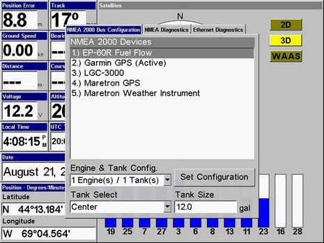
Continuing yesterday’s ode to the Lowrance LCX-113, I’ll explain how I’ve been using it to test GPS sensors against each other. Every NMEA 2000 MFD and instrument I’ve tried can handle multiple GPS (and other sensor) inputs, which is good, but they do it with a variety of styles. Some—like Raymarine’s—just grab the first one they see coming down the backbone and use it, unless it pooches out and then they will use another if available (aka “roll over on failure”). Others, like Garmin’s and Simrad’s (NX models excepted), will pick one source automatically but will also let you choose from a list of redundant sources if desired. Lowrance, as I’ve discussed before, goes a little further, letting you use more than one redundant source at once. But Lowrance does something special with GPS, because those sensors send out Dilution of Precision (DOP) values based on the strength and breadth of satellites they’re locked onto.
So far this season, I’ve had two excellent, and very different, voyages of discovery aboard Gizmo, and the test Lowrance 113–LCX HD has been very useful for both. As shown earlier this month I’ve got it rigged to a small NMEA 2000 network, which feeds the LCX the output of at least two GPS receivers, a Lowrance EP60R fuel sensor, and a Maretron Weather Station, with many add-ons possible. Check out a bigger above image , showing Gizmo up a tidal tickle in Maquoit Bay, about as far into Casco Bay as a boat can go…if the tide is high! The LCX, using just the Skimmer transducer it comes with, had no trouble with these shallow readings, even at 20 knots (once I got confident that the immense mud flats are flat indeed). Notice too the 76 degree water temp, which I’ve never seen in Maine salt water and which partially accounts for the happy bird life in this new preserve.
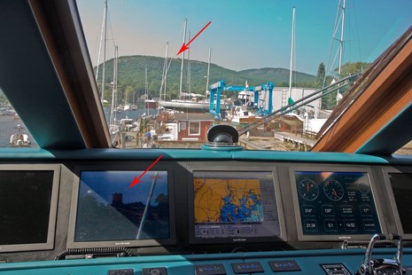
Binoculars, sminoculars! Open the bigger image to get a hint of how well Sandrine’sFLIR Voyager multi-camera system is bringing in the little tower on Mt. Battie (from which I took Panbo’s header photo). Live in person you could easily watch the tourists climbing around, and we didn’t have it totally zoomed in. But, egads, on Oct. 1 FLIR will offer a Voyager II model with some must-have features. For one thing, it will input radar cursor data and thus automatically hone in on selected targets, which could be very valuable, I think. It will also have an IP address, and thus will be remote controllable from any computer on the yacht or beyond, which could be fun.
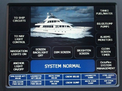
A day aboard the 120’ tri-deck Sandrine will definitely rank high on my Summer ‘08 highlight list. Wow! While I’d actually attended her debut in Miami, and was already familiar with the OctoPlex distributed power system she showcases, it takes a while to comprehend how powerful the system is. The stats help: that touch screen (embedded Windows PC) above is connected via redundant NMEA 2000 networks to 7 other touch screens, 18 electronic DC circuit breaker panels (w/18 breakers each), 13 electro-mechanical AC breaker panels (w/ 13 breakers each), and 8 System Interface Units (SIUs). Each SIU has 34 discrete inputs connected to simple ground or voltage level sensors and switches, such as the yacht’s 175 light switches.
When I was researching a PMY article about VSAT and Fleet Broadband sat comms, I asked a fairly reliable source what would happen if Inmarsat lost one of its new I-4 satellites. He rolled his eyes and said, “they’d be dead.” You see, while it only takes three of the new I-4 satellites to provide nearly global BGAN/FB service, the things are huge, and hugely expensive. Which is why getting the third and final bird into orbit was a big deal. Plus the launch has been delayed at least once due to the failure of a similar missile carrying a smaller satellite. I imagine tension was wicked high when the Proton Breeze lifted off from the Baikonur Cosmodrome in Kazakhstan last night. Can we imagine the financial stress induced watching a critical business asset—for which, by the way, there is no backup—blast into space (especially now that we know how much angst a little electronics bankruptcy can cause). Well, the I-4 F3 satellite launched fine, and thus Fleet Broadband should become global soon. Meanwhile, KVH recently announced that its mini_VSAT service is also going global. I presume that if things go right, a company can do well with satellite communications, but it does seem like a hairy business.
Bummer! The only remaining online sign of the great electronics blog AskJackRabbit is the old About Me page above. Much worse, especially for customers with paid-for orders outstanding, is the apparent bankruptcy of Jack Rabbit Marine. Online grumbling about undelivered orders and unanswered calls actually began in June, and I heard from an unhappy—like $5,000 of unrefunded deposit on canceled order unhappy—Panbo reader in early July. But, like most every one else, I figured the problems were isolated and temporary. Last week, though, the drumbeat of worried commenters at The Hull Truth, NavaGear, and here on Panbo picked up considerably, and finally a couple of customers reported receiving this email from the company’s President, Peter James:
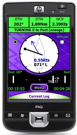
SailClever is a new kid in the sailboat racing tactical software niche, and it looks clever indeed. According to the developers, the Windows Mobile PDA screen at right “shows one of the main screens you would use while racing. It has an arrow to show where the mark is, a pointer to show the direction of current relative to the boat, navigational numbers along the top and then a bar along the bottom that shows what side of the beat you are on and your tacking angle (Downwind it shows gybe angles and reaching it shows cross track error). Pressing the menu button allows you quickly access a number of other screens that give you information on your speed relative to your polars, what the next leg is, what sail you should be using, wind direction and a basic chart.” The SailClever software will do a lot more than that, as well illustrated on its web demo pages. It can purchased alone or with a neat-looking Datasoft RS-232 Bluetooth dongle for connecting to NMEA 0183 ports wirelessly. SailClever also offers an extremely rugged TDS Nomad PDA that’s probably way out of your price range, but do enjoy the stress test video. SailClever claims compatibility with several instrument systems—sometimes two-way, as with TackTick—which distinguishes it from the higher end Ockam Eye PDA software, I think. But note that a few of its features are available in iNavX (don’t miss Gram’s latest), Memory Map, and probably some other PDA/Smart-phone apps you’ll tell me about.
As of yesterday, Furuno’s FI-50 (aka FI50) instrument family is officially available in the U.S. and Canada, and thoroughly documented at FurunoUSA. I’m a bit chagrined as I thought they’d be out much sooner, in fact chose them for a Pittman Innovation award that was partially predicated on them being out sooner. Oh well, ship dates slip…and I understand that part of the delay was perfecting FI-50 compatibility with Simrad’s somewhat quirky AT10 NMEA 0183/2000 converter. Which is good for anyone wanting to, say, use FI-50s with 0183 wind and depth data already available on their vessel (and especially good, Furuno-wise, for NavNet 1 and 2 owners who want to add the instruments). Plus the premises of my award choice have withstood actually testing some FI-50s for a while…
Check out the bigger image. That’s a new XM Satellite weather service called NavWeather that’s going to debut on a lot of Humminbird multifunction displays next January. I don’t fully understand what makes it different from the XM Satellite Weather many of us have seen on Garmin MFDs but there are some clues. The brief demo I saw and photographed at MAATS, for instance, shows NexRad radar with lightning and at least a bit of animation…which I think of as the most important elements of a live weather feed. Yet NavWeather is considerably less expensive than the current service, $10 a month with $15 activation fee and a $250 receiver. It also uses something the press release calls “Threat Matrix technology to track nationwide weather information for more than 20 different weather conditions,” and deliver appropriate alerts.
It’s wonderful that the marine electronics world is still small enough that a tiny company with a good idea can get somewhere. But I’m not sure that having your Icom M504 VHF modified by Marine Werke so it can output AIS audio signals is a good idea. For one thing, I believe only the included Shipplotter software can demodulate AIS audio, so a user can’t use this AIS target data with other software or plotters. Furthermore, to get AIS, you’ll have to tune the Icom to Channel 87 and I dare say that also scanning safety channels might significantly reduce AIS performance.
Lowrance’s LMF-400 is one impressive NMEA 2000 gauge, and I should have included it in my N2K instrument round up. On the above “fuel management” screen it’s totaling the flows of the two FloScan FloNets and calculating nm/gal using boat speed, while also showing the tank level % from a Maretron adaptor. You can easily change the data fields or build a custom screen showing from one to four data types—either virtual needle style or numeric—and thus monitor individual engine flows (good for catching mechanical problems), fuel used by trip or season, remaining fuel, and range. You can also choose data sources, set up your engine/tank configuration, and calibrate Lowrance fluid level and gasoline flow sensors with the LMF-400; it’s quite visible in sunny conditions; and the little devil can be had for about $120, only $40 more with a flow sensor. In short, it does everything you could want in fuel management, inexpensively (see way below for more details).
Good to see a new player in the marine monitor biz, especially a company as significant and capable as Planar. And they’ve arrived with a bang. The LX Mariner Touch Monitors claim a raft of desirable features, like bonded sunlight-viewable screens, completely sealed cases (IP65), and reasonable prices. They’re not in Planar’s online store or anywhere else I can find yet, but the MSRPs are $2,200 for the 15” model, $2,100 for the 12”, and $2,000 for the 8”, and I’m told the two larger units are available now if you call Planar (Ask for IBU sales).
At least one Navico competitor is having fun e-mailing around this scan of a major ad blooper that ran in a New Zealand marine publication. Of course the intended headline was “True Multifunction” not “True Malfunction” and no doubt some one is very embarrassed about the mistake. In fact, “multifunction”—as in multifunction display, or MFD—is not a term that has slipped easily into boating vernacular. The forwarded email that carried this image was jokingly titled “Truth in Advertising” but therein lies an unintended truth. Aside from the blooper, this ad better represents the actual product than some of Simrad’s other marketing.
This looks like good news indeed (and thanks to Mike Doyle for the head’s up). That little 1.25” diameter Callpod Dragon V2 Bluetooth headset can not only do the expected with your cell phone but also communicate directly with another Dragon V2 headset up to 100 meters away. So, at least theoretically, you and your mate could be working or playing most anywhere around your boat with full duplex hands-free communication as needed, interrupted only if either of you wants to take a call from the individual cell phones in your pockets. Actually, the phone might be stowed in a safer place, perhaps even hooked to an amplifier, as Callpod claims the Dragon “typically enhances the {9 meter} performance of standard Class-2 devices by a factor of 2 to 3 times.”
On Saturday the Apple iPhone app store started offering iNavX Marine Navigation and it’s already generated eight mostly positive reviews there. The $50 program is the work of Rich Ray, who also developed GPSNavX and MacENC, and it looks similarly well done. It works with the built-in GPS of the new 3G iPhone of course, but can also be used on older iPhones using cell tower location services. Alternately you can set it up on an iPhone, or iPod Touch, to get GPS, wind info, and other data via a boat’s WiFi router and a program like MacENC (or Coastal Explorer) that can output NMEA 0183 messages to TCP/IP (Franson GPSGate should also work).
This week Maptech sold it paper chart and guide book division to Richardsons’ Publications, which was already producing similar products. In fact, a principal there was working at BBA/ChartKit when Maptech purchased it in 1997. “Things have come full circle.” A nice aspect to this deal is that most of the Maptech print staff will now work for Richardsons’. Sounds like the various Maptech chart books and guides will carry on nicely..