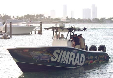
That’s me in the tan shirt, aboard the 34’ Yellowfin (run by pro Mark Maus) that Simrad used in Miami to show off its new GB40 and NX systems. I’d already covered their introduction in PMY, here and here, but still have a lot to learn about their details. The demo trip wasn’t a particularly good environment for studying details, but I did learn that both can keep up a pretty good plot even at 63 MPH! Eventually I’ll write more about the monster install in that center console, but today I want to discuss tracking that personal-fastest-ever boat ride with the test Garmin Colorado that was in my bag.
I remembered this Raymarine A60 today because Jim Hebert just did an up-to-date bench test over at Continuous Wave. I tried the unit alongside a Garmin 545S last summer and wrote about it for last October’s PMY. It also came up when the WAAS satellite change happened and I gather from Jim that Raymarine was never able to fix the RS12 GPS that’s bundled with the A60. An expensive fix is possible, but note that it did well in my testing without WAAS, and that the Raymarine A-Series page indicates that its price has dropped a lot since my PMY piece.
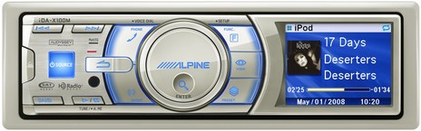
Given yesterday’s Fusion stereo discussion, how about another new iPod-friendly marine system, from Alpine. This time we’ve got a lot of online detail on units like this iDA-X100M. But I’ll note that it is HD Radio “ready” though honestly I’m not really up on what means yet (and I’m out in LD boonies).
I’ve been keeping an eye out for the new Fusion marine stereo systems since the prototypesimpressed me at METS. Well, they’re not only official as of yesterday’s announcement, but at least the MS-IP500 model above, and bigger here, is already available at West Marine, which apparently has a U.S. exclusive. And the details sound even better than what I heard in Amsterdam.
Good things first: some of the display pages available on Garmin’s new GMI 10 are fantastic, at least as gorgeously graphic and data expressive as the official product photos (like the one we used in the April PMY). Check my real world photo of the speed dial above, which can even have those Max and Avg markers something like the useful Max/Min dots seen on the Raymarine ST70. One button step into the menu system and you could use STW (Speed through the Water) instead of GPS, assuming the paddle wheel sensor is on your network, and a little deeper you’ll find a thoroughly annotated list of all your network devices and the ability to choose which you want as a preferred source. And, yes, that screen is exceptionally color rich and well back-lit (using a direct 12v feed, as Garmin chose not to power it off the N2K network). Altogether, and along with the ST70, rich NMEA 2000 data networking plus color screens and processor smarts equals a great new generation of marine instruments. But!
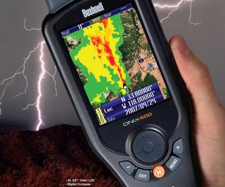
It took a while to get real, but just this morning I received assurance that I’m the list to try one of these intriguing Bushnell ONIX400 handheld plotters capable of receiving XM Satellite Weather and Audio (once they can get ahead of orders and free some units up for the media). It may be oriented to hunters, but couldn’t it be useful to boaters who want a relatively economical way to carry live satellite weather wherever they go? And, besides, how hard would be to add charts to a handheld that can already do topo and photo maps?
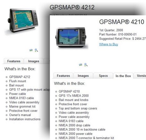
It’s fabulous that Garmin is now including, or at least plans to eventually include, a NMEA 2000 17x GPS and starter N2K backbone with its 4000 and 5000 Series networked displays (even if it took almost a year to get it all together). But if I were shopping for one of these units today, I’d be darn attentive to exactly what’s in the box. The switch from 0183 to 2000 sensor systems appears to be in transition, and I don’t know how far it’s progressed or what may still be in the supply chain (or if there is any price consequence {nice update: “no price change”}).
Thanks to a loan by the good John Gass of his test SeaTalk wind sensor, I’ve now got a Raymarine ST70 Wind Pod plugged into the lab’s ever expanding NMEA 2000 experiment. The Pod can supposedly gateway “any standard Raymarine wind transducer” onto SeaTalkNG and it was pleasing to see that it does indeed put out a standard NMEA 2000 Wind Data message (PGN 13036). All the displays read it fine. And, as suggested above, the ST70 has splendid graphic calibration and diagnostic facilities that work with the pod and sensor. You can correct the vane offset and apply a speed correction factor, either via an underway guided routine or manually. The ST70 can also query the components for model and serial numbers, software and hardware editions, even node voltage.
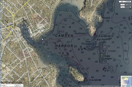
The old days may be something like the new days, but not entirely! Check out the full screen of this NOAA raster/Google maps mashup; it’s the work of Just Magic, aka GeoGarage, and is not only way slicker than what we saw two years back, but is one of the neater Camden Harbor images I’ve ever seen. Of course it helps that Google has high res photo maps for my area now, and they register so darn perfectly with the raster chart. Try it live yourself, fool with those sliders upper right, search out your own harbor, and perhaps join me with big tip of the propeller beanie to those crazy Frenchmen in their GeoGarage.
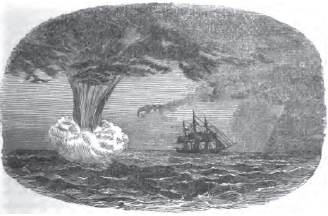
That’s not just an old drawing, it’s a sketch submitted to Mercantile Marine Magazine in 1858 by the chief mate of the ship Forerunner, and it’s accompanied by a detailed description of the spout (height of foam at base: 50’), the Southern Ocean conditions that produced it, and how Forerunner got out of its way! Mate Fletcher’s goal, of course, was to help fellow sailors understand water spouts better, and maybe brag a bit. I came across this bit of history in the most modern and wonderful way. I was Googling the name of a certain European lighthouse that might appear in one of PMY’s photo/chart contests, and one link I got was to the Google Books version of MM Magazine’s 1858 bound edition. And, mercy be, all 384 pages are searchable, downloadable, and fascinating.
OK, admittedly I’m in a foul too-much-work mood, and maybe that’s why I find NASA’s new AIS Engine 2 so totally exasperating. Sure, they added “Power” and “Data” LED status lights, a big improvement over the original, but that’s just catching up with the Smart Radio SR161 that has deservedly stolen much of NASA’s business at the low end of AIS receivers. And note how Milltech carefully explains that the SR161 only receives one of the two AIS channels at a time, scanning back and forth, while the NASA specs are, um, less clear about that limitation.
Last Wednesday night, the 97' clam dredge Captain Joe sank suddenly 30 miles off Point Pleasant, New Jersey in 10' seas. Air and sea temperatures were in the low 40’s and the wind NW near 30 knots (according to a nearby C-Man buoy). You can hear some, maybe all, of the bone-chilling May Day call here. It’s unclear whether the crew gave any position info before jumping into their liferaft, yet within hours rescue swimmers helped all four into the baskets of two USCG helicopters.
Here’s a reversal: I tested this Matys OnBoard Iridium/GSM distress/SMS/voice/email communicator months ago, and my PMY write-up is already online. There you can see the reassuring way the unit lets you know that an alarm message has been received, quickly too, as well as the system’s substantial cost. And the Matys site is good for the seemingly endless—tracking, weather, concierge, medical, etc.—services available.
Well, hot damn! How about a full featured PC planning product that includes maps for 10,000 U.S. lakes, all on a $20 DVD? I just heard about it this morning, but my first impression of Navionics HotMaps Explorer is “who wouldn’t?” Well, I suppose if you never, ever go out on lakes, but I do and was pleased to see that the coverage list includes a lot of Maine lakes. Now my favorite, Lake Megunticook, is not covered by any digital map maker, I don’t think, though I keep hoping that Navionics will do one of its high definition surveys there and let me see at least some of their techniques. By the way, the download of one HD lake map is included in HotMaps Explorer.
So I hope yesterday’s goofy contest made a point about Raymarine’s STng cabling system. I do think the design has merit, particularly for production boat building, and there’s more of interest, like heavier gauge power wires, that I’ll get into eventually. But today I’m going back to the larger point that NMEA 2000 cabling is not that big a deal. As noted earlier in these ST70/STng experiments, the data flows easier than one might think given the different connectors and network names. What really counts is that the desired data is sent and received. I learned that vividly when the first Garmins could hardly understand any N2K PGNs (messages), despite having a standard NMEA 2000 connector, and now I’ve stumbled on an ironic reminder.
I’m on deadline today, and may find no more time for posting, but here’s a puzzle to ponder. Those two male female connectors above are unique to Raymarine’s SeaTalkNG (or STng) version of NMEA 2000 cabling. The white version is on both ends of every “spur” cable that’s used to connect devices to the backbone—or to daisy chain one device to another—and the blue version is on both ends of every backbone segment. So why in tarnation does one have six pins and the other five?
If you own a Raymarine E-Series MFD, you are about to get a lot of free new features—and some new accessory shopping possibilities!—thanks to a V4 software update coming this month or next. The screen above shows the new “steering bar” as well as support for Navionics Platinum+ chart cards and—bigger here—their much improved photo and 3D resolution, even if the docks are on the Cape while the banks are in the Bahamas (for more on Platinum+ check out this video).
My PMY March column about SPOT is now online, and you’ll see that I gave the company guff for what I thought was “hyped-up fear marketing.” But in fact they’ve toned that down quite a bit recently. The “Live to tell about it” tag line is still around, but the home page closeup of the toothy, drooling bear and the lame homilies—like the one about coming home in coach instead of in cargo—have vanished. I’d like to think I had something to do with it, but more likely is the marketing realization that Spot’s real draw is its ability to do tracking and non-distress messaging.
Engine shut-off systems, Autotether most attractive?
Mar 6, 2008
Who’s going to argue with that admonition? I first noted MariTech's use of the female form to sell its Virtual Lifeline wireless engine shut-off back in ‘05. While they may have switched body parts, these days the system itself seems pretty similar, a good sign of effectiveness really. But it looks like they’ve got a serious new competitor in Autotether, which at least seems to offer more features for less cost.
A month or so ago reader Derek Love (thanks!) wrote in about an interesting combination VHF transceiver and AIS receiver previewed by Icom UK at the London Boat Show. It got a little coverage plus there’s an Icom UK web page about it, though that page seems oddly inaccessible from the main site. I’ve tried to find out more and what I hear is that the prototype is a small board that can be added to Icom M505 and M603 radios, but preferably during manufacturing, not as after-market mod, because of the waterproofing.
Another sign that 2008 is the year of NMEA 2000? Airmar tells me that orders for its various N2K Smart Sensors—depth/speed/temp info online now, high performance PB200 Weather Station plus GPS/compass and plain compass coming “soon”—are way ahead of projections. Plus the company is now offering “a full-line of affordable, NMEA 2000 certified cables and accessories.” I’ve got some samples in the lab, bigger picture here, and the cable is a wee bit thinner than the gray Micro size I’m familiar with—a little less individual wire insulation, I think—but otherwise seems very similar. The cabling source is LTW, and Airmar says it’s “been rigorously tested to comply with the NMEA 2000 standard.”
So today I got a 512 Meg SD card and thus can now take screenshots on the Northstar M121. One I wanted to show you is this nifty “About” screen which includes the color coding for most of the unit’s possible input/output wiring, and which turned out to be particularly timely because C-Map just initiated a recall for certain Max chart cards if used with certain plotter software. If and when you go the C-Map Recall page, what you’ll need to know is the “cartridge code” shown in “Slot 2” above and the plotter’s software version, shown upper left. In fact, the recall only involves Max cards dated prior to October, 2006, and only certain plotters, mostly early versions of Si-Tex, Interphase, Standard Horizon, Cobra, Furuno, and European machines (that all run Max cartography).
Almost every time I walked by Furuno’s demo area just outside the MIBS madness Electronics Room, it looked like the scene above, i.e. full of folks intently learning about NavNet 3D. But while last Fall’s NN3D buzz continued, the negative word around MIBS was that Furuno didn’t yet have a shipping date, and wasn’t even taking orders. “Nice system,” competitors said, “but you can’t get it!”