Panbo

February 2008 Archives

Iridium OpenPort, a solid state touché!

Feb 29, 2008

Iridium_OpenPort_AnBDUs

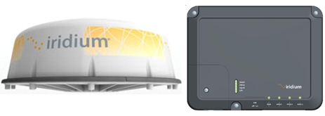
Doh! Earlier this week I wrote a PMY May column on marine satellite broadband, but despite lots of research only this morning learned that Iridium is also piling into this relatively small, if high dollar, niche…and with what looks like a really interesting new technology. The omni-directional antenna inside that 9" by 21" dome above has no moving parts, and yet can supposedly provide three phone lines and “up to” 128 Kbps of mobile Internet connectivity anywhere on the globe. Thats not nearly as fast as what VSAT and Mini-VSAT can do, but it’s darn close to Fleet Broadband 250 abilities, and may be plenty good enough for many offshore yachts and commercial boats. In fact, if Inmarsat’s IsatPhone looks like a competitive lunge at Iridium, this sure looks like the “touché”! The OpenPort press release doesn’t mince words:

Continue Reading

Northstar M84, screenshots & more

Feb 28, 2008

Bruadair M84 split screen

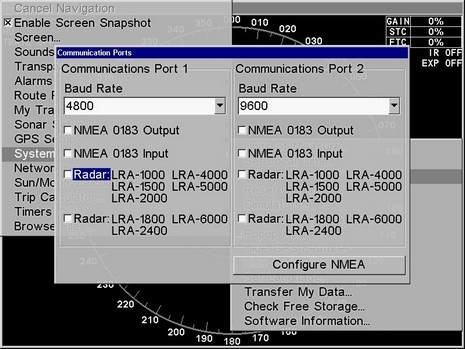
Well, I’ll be darned. As Damon pointed out in the screenshot entry, the Northstar M Series also has the feature. It’s not hidden either; I plugged in the lab’s test M121, and the command is right there on the System menu (ahem), and self explanatory. I did hit a snag creating a “User Card”, though; it took a call to Northstar support to find out that it can’t exceed 512 Megs and, sigh, those cost as much as bigger cards these days. At any rate, one is on its way, and soon I’ll put the unit through a Kagstrom AIS simulation.

Continue Reading

Lowrance Broadband Sonar, demo impressions

Feb 27, 2008

Lowrance_Broadband_split_MIBS_trials

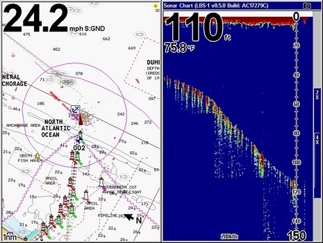
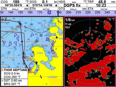
Now that you know how I got the screenshots, here are examples of Lowrance’s new networkable Broadband Sonar as seen on the HD (hard drive) version of a GlobalMap 9200C. (The 9300c HD, oddly, doesn’t seem to be listed as a current product?)  The full 800x600 screen above gives you some sense of the scene as we exited Miami looking for deep water and fish. (Yes, the Lowrance radar was running, but possibly wasn’t tuned, and certainly looked a lot better in the harbor at slower speeds.) What you can’t see is the dinky transducer (this one, I think) that was hung on the stern of the 330 World Cat demo boat (with, yeeha, twin 300 hp Suzukis). Remember that the LBS premise is amazing performance with only 250W of peak-to-peak power, “a whisper instead of a shout” as Navico likes to say.

Continue Reading

A screenshot feature, do it!

Feb 26, 2008

Lowrance_Screen_Snapshot_cPanbo

Whereas I got the week started on what’s largely a trade subject, let me add an unsolicited suggestion to everyone who makes plotters, multifunction displays, or any other marine electronics with a dedicated screen and some sort of accessible memory. If possible, please add a screenshot feature! My intent is obviously selfish; dumping .jpg or .bmp files to a CF or SD card is so much easier than photographing displays, and the results so much better for web and magazine readers. 

Continue Reading

Maptech, big changes coming

Feb 25, 2008

Maptech_Mapserver_II_cPanbo

It’s ironic that I wrote about a neat Maptech price/packaging move Friday afternoon, as I now know that simultaneously the employees were learning that the company would be sold, either whole or in parts, and that it would immediately go into a sort of maintenance mode, which included a few layoffs. Naturally the relatively tiny marine electronics industry has been a-buzz about this ever since, and naturally a lot of conjecture, if not pure BS, has already accrued. Here’s what I know:

Continue Reading

Maptech International Charts, prices slashed

Feb 22, 2008

Maptech_int_charts_price_drop_cPanbo

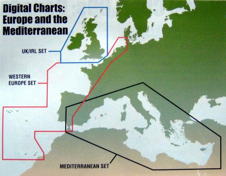
One of my happiest discoveries at MIBS was not a new product or feature, but simply a matter of pricing and packaging. Maptech has radically reduced the hassle and cost of owning its international raster charts, really big time.

Continue Reading

eLoran, game on!

Feb 22, 2008

ELoran_20concept_small2

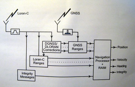
Remember all the hand wringing about shutting down the Loran system? Well, the inimitable Langhorne Bond was right again; the USCG’s threat was in fact just smart politics. President Bush’s 2009 budget “migrates” Loran responsibility from the Coast Guard to another Dept. of Homeland Security (DHS) unit called the National Protection and Programs Directorate (NPPD). The budget further states that NPPD will be responsible for finishing the transformation of Loran-C to Enhanced Loran (eLoran). On Feb. 7, DHS announced eLoran will not only back up marine and aviation GPS navigation, but enhance navigation for “first responders” and others operating in difficult GPS environments. This is a big deal.

Continue Reading

PAW, nifty & free Smartphone weather

Feb 21, 2008

Usne_new_frad_anim_none

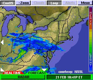
A great tip from Panbo reader Russell D.: The Space Science and Engineering Center (SSEC) at the University of Wisconsin offers a free PAW (PDA Animated Weather) service that looks like it would work well on Web enabled PDAs and Smartphones (also as a Google Gadget). That animation above is the New England Regional 15 Minute image and it even shows something called NSSL Forecast Radar, i.e. a computer guesstimate of where the precip will be in an hour (I grabbed the image at about 11pm). I’ve heard of this technology, but this is the first time I’ve seen it. PAW covers most of the U.S., often in metro detail, and a scattering of foreign locations. The data for any given place varies, often in interesting ways (research center!). Like check out New Zealand with jet stream and radar. Unfortunately I’m only peeping at this on the Web. You readers able to try PAW with something mobile…please report back. Thanks Russell! Oh, and if this pushes your button, also check out Memory Map’s Weather Radar, which may well be a more consistent, and data efficient, resource.

Humminbird horizon compass, brilliant!

Feb 21, 2008

Humminbird_1100_series_plat_3d_cPanbo

Some day I’ll figure out how to use the “tag” function built into this blogging software, and this entry will be one of several easily found by clicking “Smart Interface Ideas”. I’ve never seen a compass rose overlaid on a 3D plotter horizon like this, but it struck me as totally intuitive, very useful, and without a downside. Check out the big image and imagine yourself driving up Biscayne Bay toward the Miami River and the MIBS madness beyond. Notice how 3D gives you buoy and bottom detail near your position plus a good, if less detailed, sense of what’s ahead. (In this particular case the bottom contours aren’t very emphatic, but if you look at the 2D raster of the same area, you’ll see there isn’t much depth differentiation around here, and there was probably a tweak we could have done to emphasize it. It’s also evident that the wire frame boat icon is a bit large, putting the green lit mark in the galley!)

Continue Reading

Northstar 725, w/ 705 wireless handsets

Feb 20, 2008

Northstar_Explorer_725_VHF_w-_Wireless

This Northstar Explorer 725 VHF, along with its optional wireless handset, was one of the few entirely new electronics introductions seen at MIBS (at least if you’re a regular Panbo reader ;-). And compliments to Northstar for using real screens in these product shots, instead of pasting in dummies as is often the case. It is a bit humorous, though, that while the photographer did manage to power up the units, he clearly did not attach a GPS, which is why the fixed unit is plaintively displaying “PLEASE INPUT POSITION!” so that it can do its DSC duties properly.

Continue Reading

NVTI target tracking, demoed

Feb 19, 2008

NVTI_tracking_function_MIBS_cPanbo

I wrote about the nifty target tracking abilities built in to NVTI’s high end multi camera devices a while back, but got to see them in action in the MIBS electronics room. The engineer/demonstrator used that show goer’s hot face to show me how the model 6000’s own computer could lock onto a thermal target and command the camera to follow it. In fact, it tracked the poor guy for about 100 feet as a strolled down the aisle, actually felt like someone was staring at him, and then discovered himself on the NVTI monitor. Things get weird like that in the electronics room. The camera was also impressively able to lock onto the end of a swinging six foot radar array way across the room, which made for dizzy imaging, and I bet it would have worked fine with that cold glass of beverage above. Note, too, the ARPA radar targets listed lower left on the screen above. Pick one and the multi camera casing swings to it pronto. And the latest feature is that AIS targets can also be listed across that monitor, subject to instant tracking. Cool!

MIBS, the madness

Feb 19, 2008

Crazy_MIBS_n_FLIR_demo_cPanbo

Dear readers, sorry for the dead air! I intended to post at least a few times during MIBS (Miami International Boat Show), but your boy way over booked himself, and sometimes had a little too much fun. For starters, I got pretty consumed with the two-day NMMA Innovation Awards judging process, which turned out to be impressively serious and well organized. There were lots of worthy entries into the Consumer Electronics category, which was won by Furuno’s NavNet 3D with Honorable Mentions for Standard Horizon’s HX850S combo VHF/GPS and Globalstar’s SPOT. The full Awards press release is here. Then there were the rounds of press conferences and booth visits, and this year no less than six on-the-water electronics demos. That “Miami madness” shot above was taken during the FLIR thermal imaging cruise, which was blogged by MadMariner’s Tom Tripp. Embarrassingly, Tom also managed to cover lots of other MIBS highlights, electronic and otherwise, and my mates from PMY produced a really neat set of show videos.

Continue Reading

Kagstrom's AIS Simulator, and good B news

Feb 13, 2008

Mats_AISsim_lots_cPanbo

Man, the AIS traffic was heavy out there in the Gulf of Maine! Actually I was using the very neat AIS Simulation software created by Mats Kågstrøm of Firma Mats Kagstrom. Specifically I was testing how many AIS targets a Raymarine E-Series can handle simultaneously, as I got a report from a user who says his resets randomly when more than 100 ships are within range. Well, I did see the test E slow down, even stutter a bit, but I was able to feed it the maximum number of targets the simulator can produce without causing a reset. That’s some 510 Class A targets (!), plus a Class B (which the E “saw”), and even SAR aircraft and ATON AIS target messages (which the E doesn’t seem to understand). You can see Kagstrom’s software in action below, and bigger here.

AIS Simulator is very thorough and is going to be terriffic for testing navigation hardware and software. But I’ll write more about later, because I don’t want to head back to my judging duties until I pass on the good news about Class B AIS. To quote one of the many cautiously optimistic emails I got on this subject yesterday (thanks, all!): “We heard from the FCC that it looks like the AIS Second Report and Order will be on the Commission's Agenda for the Feb. 26 meeting. There is a *chance* that the item will be voted on before that time.” Maybe our letters and emails helped, but I also know that the GMDSS Task Force, the USCG, and the RTCM have all been making their feelings known to the FCC. The latter even spoke with an FCC legal aid, very effectively too, as judged from this PDF documenting the meeting (also a good summary of the situation). Cross your fingers!

Mats_AISsim_screen_cPanbo

Ray ST70, hand's on #1

Feb 8, 2008

Ray_ST70_AWA_min_max_cPanbo

This ST70 not only plays pretty well with the various non Raymarine sensors on Panbo’s NMEA 2000 test network, as mentioned earlier this week, but it’s also loaded with neat surprises. One is those little minimum and maximum dots on the outer ring of the digital Apparent Wind dial above. Many instruments will track min/max of some values, but I’ve never seen one that does it graphically like this. Have you? Plus when you press that menu button from this page, your first choice will be to reset those min/max values. Friendly.

Continue Reading

Actisense QNB-1, N2K breakout box

Feb 7, 2008

Actisense_QNB-1_crop

Ah, yet another doodad useful for installing a NMEA 2000 network, an economical one too. If used to the max, Actisense’s brand new QNB-1 “Quick Network Block” takes the place of 6 regular N2K tee connectors, 8 cable connectors, and a separate power supply (like most of this). Plus all the N2K cable ends run into it can be run through smaller holes and tighter spaces than even those skinny SimNet connectors, and they can be cut to fit perfectly. And I don’t see why it can’t be used with proprietary flavors of N2K cable too (the possible exception being SimNet because it lacks a distinct “shield” wire). The QNB-1 even includes 4 amp blade fuses for each side of the backbone, and LEDs that indicate power on/off/reversed and data activity, and it will retail for about about $146 (available in the U.S. from Gemeco).

Continue Reading

PassageWeather, first impression

Feb 6, 2008

PassageWeather screen cPanbo

PassageWeather.com is apparently brand new, but impressive, offering free 7-day sailing forecasts for all oceans, updated 4 times a day. The interface seems clean and fast, data sources are explained, and you can download forecast charts easily. The region organization is nice too, and note that the ocean race routes are always forecast, so you can, as above, quickly see that heading, say, Norfolk to Bermuda today could be one fast passage, in the right boat. PassageWeather is no where near as ambitious as ClearPoint, but it seems well done. Your thoughts?

N2K, cable mixing not a big woop

Feb 5, 2008

Cables_N2K_SeaTalkNG_SimNet

My macro photography needs improvement, as does my cable stripping, but I think this shot makes a point. From the left, the cables above are standard (DeviceNet) NMEA 2000, SeaTalkNG (aka NMEA 2000), and SimNet (aka NMEA 2000). Notice the similarities. The internal wires all adhere pretty closely to the NMEA color standard, which goes as follows, “Net” nomenclature included:

Continue Reading

PN-20 vs Colorado, handhelds on ice

Feb 4, 2008

DeLorme PN-20 n Garmin Colorado cPanbo

I’ve had a Garmin Colorado here for a week or so, and while there’s a lot to like about it, screen brightness is disappointing (especially given Garmin’s recent fixed plotters). Here it is alongside the DeLorme PN-20 out on Lake Megunticook near dusk this afternoon, bigger photo here, with both screens turned up to maximum brightness. Note however that the DeLorme may have the brightest color screen I’ve ever seen on a handheld, though it’s also pretty small, particularly compared to the Colorado. By the way, despite all the maps, charts, and photos each of these devices can display, I don’t think there is an electronic navigation ‘chart’ available for Megunticook in any format. Lakes are funny that way…i.e. there is no Government agency tasked with mapping them all. More on both handhelds eventually. Oh, and what was I doing out there on the ice? Well, we lost all our snow in a few rain storms, and so I’ve been learning how to use a pair of 21” Nordic cruising skates. They’re great!

RFIDs for DHS, AIS later?

Feb 4, 2008

DHS_report_graph

“The nation’s 18 million recreational boaters may need to register their crafts in a national database and place radio frequency identification tags {RFID} on their vessels under plans put forth by a stakeholders group convened by the Homeland Security Department {DHS}.” So says an article in WashingtonTechnology. The idea, um, doesn’t sit well with the editor of Sailing Anarchy, who described it today as, “an example of what the some of the jackals at ‘Homeland Security’ think fighting the ‘war on terror’ is about…This is a pathetic joke, a national embarrassment and an outrage that this is what the Bush government is up to.”

Continue Reading

NavNet 3D, moving toward the nitty gritty

Feb 1, 2008

Furuno_NN3D_multi_monitors

I don’t know when NavNet 3D will actually ship, but the nitty gritty details are emerging. There’s a very useful NavNet 3D FAQ (PDF) up at Furuno’s “Learning Center” (lower right, under Reference Materials). I’ve only skimmed it but was pleased to read how nicely NN3D handles multiple N2K GPS, depth, and other sensors (you pick a preferred sensor and the whole system will honor that preference unless it fails, when a backup will automatically be used). There’s also a good explanation (above) of the blackbox version’s support for multiple monitors, a great feature that’s hardly been mentioned yet by mutts like me. Fortunately, too, a Panbo reader with a strong personal interest in NN3D sent me notes on the FAQ—some enthusiastic, some skeptical, and some perhaps based on misunderstandings. Check it all out and add your own two cents:

Continue Reading