
Navionics Mobile, & other iPhone apps
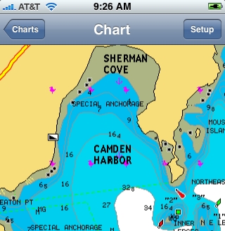
It’s come to my attention that not every Panbo reader is obsessed with AIS! So how about a new charting app for the iPhone? That would be Navionics Mobile, which was just introduced at the Genoa Boat Show. It is, in fact, a relative of iNavX, the first iPhone charting app (why reinvent good code?), though obviously different. iNavX can’t download a NOAA raster chart of Genoa, Italy, for instance, and no raster chart can offer a choice of nav aid presentation as illustrated in the split screen shots above and below…
With Navionics Mobile you’ll also be able to query chart objects—like, perhaps, the detailed characteristics of a nav aid—and “much more” according to a brochure I’ve seen. Oh, and navigate ski trails of “over 460 resorts in the alps,” a feature that will no doubt expand as Navionics gets into Discovery Charts. I don’t know what the app will cost when released, but you can see it at coming boat shows and/or sign up for notification of availability.
Meanwhile, a third iPhone nav app from Navimatics is already at the Apple app store, but since it’s based on NOAA ENC vector charts, I don’t think it offers complete U.S. coastal coverage yet. (Note that Navimatics also makes ENC-based Garmin charts that look good, but may also be incomplete until NOAA finishes the ENC portfolio.) Remember too that ActiveCaptain Mobile for the iPhone is “coming soon,” and it will be the one that can also use the phone to connect with a live cruising POI site. While traveling the last several days, I saw iPhones everywhere, plus visited a San Diego Apple store that was by far the most crowded in the mall; apparently even ship pilots are into the darn things.


I have started beta testing for iNavX so I can’t say much here, but while I prefer raster charts to vector charts, the advantages of potential extended regions of coverage are quite exciting. As far as use by professionals go, I turned a friend of mine onto iNavX who is a Tug & barge first mate as well as yacht delivery captain. He ended up navigation almost an entire 30 hour delivery using the iphone because the boats gps crapped out early in the trip. He now swears by it as a backup he will always have with him.
Excellent, I was hoping you’d have a look at Navionics Mobile. If the fellow from Navimatics ever gets back to me, I’ll see if there’s some way he can let you see his iPhone ENC app. You da iMan.
I had a chance to purchase and use Marine Maps for Oregon and Washington…
For complete disclosure, I am the developer of iNavX Marine Navigation app which uses NOAA RNC raster marine charts (not maps).
Marine Maps is a very basic marine chart (not map) viewer. It is not a functioning chart plotter. I would not recommend using it for navigation, but it is handy to look at the NOAA ENC vector charts. A decent first start. Hopefully more functionality will be added soon making it useable for navigation.
– Very quick scrolling and zooming although scrolling is not animated based on drag acceleration
*- App returns to last place looking before exiting
*- A basic US chart is included
*- No way to measure distance or bearing
*- No way to create or navigate to a waypoint
*- No indication of speed or course
*- Detail coverage missing for many areas as NOAA ENC coverage is incomplete (not developers fault)
*- The chart switches to a very low scale when scrolling and zooming making it difficult to know where you are looking
*- Often times, the search keyboard and input field come up after zooming
*- No way to update the charts straight from the FREE NOAA ENC website as the charts are embedded in the app
*- No chart version info
*- While the chart rotation is interesting, it would be a nice way if there was a way to “lock” North Up
*- Zoom out is limited to 1:5000,000
*- Zoom in is limited to 1:5,000
*- Soundings fixed in meters
*- When tapping to get info, the list is sorted by largest to smallest item (area, line, point)
*- Typical of ENCs often times, text overwrites other text
*- Area borders not plotted using proper marine symbols
*- What format is lat,lon entered in?
*- Large download (33+ MB) size makes for very slow iPhone synching
I e-mailed the Navimatics guys as well, but never heard back. If you have any better luck let me know. Richard from iNavX apparently bought a copy and gave a review in the app store (fully disclosed his business interests) and from the sounds of his (admittedly biased) review it sounds like the Navimatics app has a lot of features missing such as waypoints, SOG, COG. I would love to try it out and see it, but $50 is bit too steep for educational purposes only and I am very happy with iNavX for my actual navigational use.
Head’s up: ActiveCaptain Mobile for Windows is now available as a demo and for pre-release sales. Folks who travel a lot should pay particular attention as ACM pricing is changing. The good news is regions with software for $20; the bad news is that the all region package is going up, but not until Nov. 1.
I don’t have a Windows Mobile phone but hopefully some of you who do will report back.
http://www.activecaptain.com/GM/ACMWM-PR.php
Just checked out the Active Captain site – still no coverage for the UK and looks like it needs Windows Mobile 5 – which is a pain as I’ve got WM-2003….
I’m working on the UK charts right now!
I am the founder of Navimatics Corporation that develops “Marine Maps” for the iPhone. I deeply apologize to anyone who has sent email to us and has not received a reply. Apparently our mail server has been dropping certain mails without our knowledge. This problem has been fixed now. Please feel free to resend us your questions by our Web site contact form (click on my name below).
By the way, our latest update includes waypoint support, and distance/bearing to waypoint. We have not incorporated SOG and COG yet for good reason: we have found that the iPhone GPS signal is rather erratic and cannot be used directly to accurately compute velocity. We are working on an advanced filtering technique that should produce results that can be used reliably for navigation.
Thank you and regards.
I finally got around to loading the Navimatics “Marine Maps” and have a first look up on my blog (use link in my name below). Some of GPSNavX’s concerns have been addressed and it renders beautiful maps, plus the search feature could be a game changer. More to come when I have a chance to try it on the water.
iNavX 1.0.5 is available now. It adds pinch zooming to charts. Once Navionics charts (which have complete coverage) are available for iNavX, object (i.e. port name, navaid) search will be available.
Did you see my product Water Map on Itune? it covers US East Coast S-57 at a cost of just 9.99 USD.
Regards
Andy
[email protected]
Hi Andy,I just downloaded and tried your application,it is simply Great!! and moreover Cheap!! what about the rest of US?
Hey Andy!
Your product is Cheap, but it is not so great!
it is a nice viewer with large coverage,
but does not have any additional functionality like tracking. when these are going to be available??
William Brown
Hi guys,
Thanks for your comments,
Yes we still have to improve on functionalities side.Good News is that now we are covering full US.
However let me say that our first intention was to create a simple viewer with lot of details and large coverage. Professionally also as we are utilizing S57 NOAA charts.
Due to the high demand of our software we are now working hard to improve also the functionalities.
We will do that soon.
However do remember that that our first priority was to cover whole US with a few products.
Here our motto: The NOAA charts are free why the customer has to pay a lot for that
Thanks for posting, Andy, but let’s not forget that NOAA’s S-57 chart portfolio is only about 60-70% complete (last I heard). I believe that there are important NOAA raster charts in all U.S. regions that have not yet been converted to the S-57 (aka ENC) format.
In fact, I heard that the whole S-57 conversion project was stalled for a period this year due to lack of funds, but understand that it is back underway. Maybe someone can clarify?
We chose to support the NOAA RNC (Raster Charts) with iNavX instead of the NOAA ENCs because NOAA lacks large scale detail (soundings, obstructions, etc) in at least 35% of areas where RNCs have such detailed coverage, NOAA is keeping the RNCs up to date. Applications such as FlyToMap and Charts&Tides use a bundled compressed version of the NOAA ENCs (SENC). As such you are at the mercy of the developer to update the app (a very large download) with new charts (if and when NOAA updates the ENCs). Where iNavX downloads the very latest versions of the RNCs straight from the NOAA servers. Once downloaded, the raster charts are available to be used at anytime without internet connectivity. While iNavX does cost more then these other apps it offer additional features such as the ability to transfer waypoints, tracks from popular PC navigation software. One benefit of the ENCs was the ability to search for any navaid, marina, object. iNavX now supports the same ability with the raster charts. Finally most users like the look of raster charts because they are digital scans of paper charts they already use and work with often.