
PN-20 vs Colorado, handhelds on ice
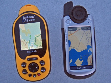
I’ve had a Garmin Colorado here for a week or so, and while there’s a lot to like about it, screen brightness is disappointing (especially given Garmin’s recent fixed plotters). Here it is alongside the DeLorme PN-20 out on Lake Megunticook near dusk this afternoon, bigger photo here, with both screens turned up to maximum brightness. Note however that the DeLorme may have the brightest color screen I’ve ever seen on a handheld, though it’s also pretty small, particularly compared to the Colorado. By the way, despite all the maps, charts, and photos each of these devices can display, I don’t think there is an electronic navigation ‘chart’ available for Megunticook in any format. Lakes are funny that way…i.e. there is no Government agency tasked with mapping them all. More on both handhelds eventually. Oh, and what was I doing out there on the ice? Well, we lost all our snow in a few rain storms, and so I’ve been learning how to use a pair of 21” Nordic cruising skates. They’re great!


Since I have not seen much reports/tests/screenshots with Marine/BlueChart maps of Garmin Colorado it would be great if you can publish some screenshots of Colorado with marine maps (BlueChart g2 and 3-d view). I think this would help lots of interested people to evaluate Colorado for marine activity.
You can go to the Garmin website for a look at the Colorado 400c. This unit comes preloaded with maps for the coastal waterways.
https://buy.garmin.com/shop/shop.do?cID=161&pID=11024
There is also a 400i for inland lakes and waterways.
If you click on the product image on the linked page, it will take you to several additional images and screenshots.
Nice, but ‘tie-unders’ are of course not the ‘real’ stuff. Over here, only these count: http://www.viking.nl/indexe.htm
Now if we could actually get some _winter_ over here everyone would be happy!
Greetings from (near) Amsterdam
When connected to a PC, the Colorado only connects as a USB mass-storage device. It does not support the normal Garmin communication protocols, which means it is not compatible with any third-party software. So if anybody wants to plan routes or waypoints on a PC, they have to buy the Garmin charts.
I’m not sure about that, Richard. There’s a “Serial Interface” tab on the System menu, with choice of Garmin In/Out, NMEA In/Out, and Text Out. I’m going to take this Colorado 400c to Miami and hopefully give it a workout.
Well, I tryed the PC connection. Yes, the laptop treats the Colorado like a flash drive, but Garmin’s Trip & Waypoint Manager can move routes, tracks, and waypoints back and forth in the normal fashion. A charting program, though, apparently can’t see the USB connection as a com port, though.
But that leaves one to wonder what that NMEA serial connection selection is for? There’s nothing in the manual about it, and it could well be that it’s meaningless until a future firmware upgrade.
It seems to change modes when you connect to the PC. I’m hoping it’s a bug they are going to fix.
Garmin USB does not support NMEA (the standard for marine instrumentation), but using the Garmin ‘PC data cable’ can be purchased to extract NMEA from the Colorado..
https://buy.garmin.com/shop/shop.do?pID=1169
Of course you will want to combine that with a USB to serial adapter.
I wish Garmin would provide NMEA data over their USB cable.