
PAW, nifty & free Smartphone weather
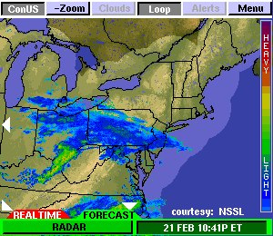
A great tip from Panbo reader Russell D.: The Space Science and Engineering Center (SSEC) at the University of Wisconsin offers a free PAW (PDA Animated Weather) service that looks like it would work well on Web enabled PDAs and Smartphones (also as a Google Gadget). That animation above is the New England Regional 15 Minute image and it even shows something called NSSL Forecast Radar, i.e. a computer guesstimate of where the precip will be in an hour (I grabbed the image at about 11pm). I’ve heard of this technology, but this is the first time I’ve seen it. PAW covers most of the U.S., often in metro detail, and a scattering of foreign locations. The data for any given place varies, often in interesting ways (research center!). Like check out New Zealand with jet stream and radar. Unfortunately I’m only peeping at this on the Web. You readers able to try PAW with something mobile…please report back. Thanks Russell! Oh, and if this pushes your button, also check out Memory Map’s Weather Radar, which may well be a more consistent, and data efficient, resource.


Nice tip. I tried it on a few phones. Works really well.
You can get similar things in other places but it is very nice how SSEC formatted everything for smaller screens including the ability to zoom in and out, change between radar and cloud cover – all right on the image.
I’m not sure you noticed, but they also provide animated forecast radar and forecast cloud cover displays.
It’s very nice how everything is tied together on one screen. It’s on my first page of bookmarks on my phones starting now.
The site has some nice features, but there are a number of problems with using animated GIFs for radar loops, apart from data efficiency. First, mobile devices have a wide variety of screen sizes and resolutions, while the web site can present only a limited choice of image sizes. If the image is resized in the mobile browser, it is unreadable. Second, I find I need to see the full detail of the radar image: a reduced resolution thumbnail is just not enough…. which is why I developed Memory-Map Weather Radar!
For cloud cover, I use the hi-res satellite imagery from
http://weather.cod.edu/analysis/analysis.1kmvis.html. This is detailed enough to predict thermal breeze development (which is key for racing on Lake Ontario!).
And for the full range of NWS forecasts, I use http://mobile.shr.weather.gov
Richard.
That’s odd. The images on my devices look outstanding (I tried 5 different ones). The interface is really simple and again, I like the forcasted radar animations.
Never underestimate the power of free software!
I have a T-Mobile MDA, and I love the enormous amount of applications available for my device. I’m only a novice fisherman, but I had not even considered using it for this type of navigation.
Ask Brent