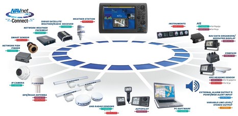
Yes, a first look at Furuno’s NavNet 3D had me burbling “incredibly sexy”—and I will explain that!—but today let’s talk about how thoroughly the 3D system embraces NMEA 2000. For starters there’s a standard N2K connector on each of the three NN3D displays, and the Product Guide lists lots of specific standard PGNs they can input and output (so there should be no Garmin-type data surprises). Now check out a bigger version of the NN3D “building blocks” diagram above to see how many N2K sensors Furuno itself is offering. Besides the FI-50 instruments already discussed, there’s an interesting N2K SC-30 GPS Heading Sensor (said to be reasonably priced and very accurate), an N2K Weather Station, an N2K Smart Transducer, and an N2K GPS. Now at least a couple of those are obviously rebranded Airmar products, but note too the odd “Ethernet…dotted line…NMEA 2000” label on the UHD Radar Sensors (mentioned yesterday). You see each of those scanners has an N2K connector on it, able to both power any of the Furuno N2K sensors and take their data, packetize it onto NavNet, and deliver it around the boat (and beyond, if and when Furuno decides to extend NavNet like, say, N2KView). The sensor data coming through the radar scanner is available to any manufacturer’s N2K device via the NN3D display’s port, and I’m told that any N2K data, even proprietary PGNs, going into that port is put onto NavNet. The installation possibilities are pretty amazing. Like radar, weather, and GPS from an antenna mast with only one power cable and one Ethernet cable. At any rate, Furuno may be one of the last of the big marine electronics manufacturers to adopt NMEA 2000, but, man, didn’t they!
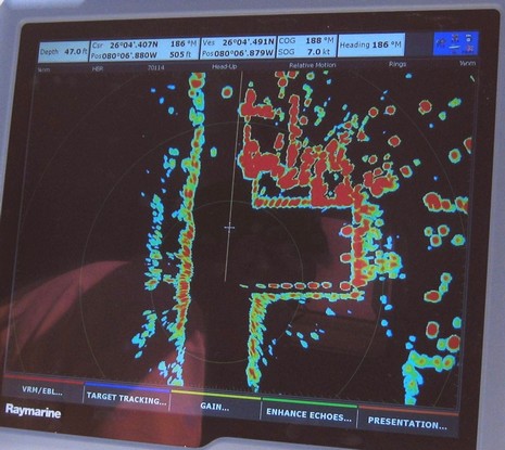
So let’s see if I can show you why I called Raymarine’s new high def radar demo “stunning” last week. First take a peek at the 1:10,000 chart for the section of Ft. Lauderdale canal shown above at 1/2 mile radar range, understanding that we were in head-up mode going almost due South, putting what I’m told is a submarine pen to starboard. Now look at the bigger screen photo here, plus the wide angle photo below, taken a moment earlier through a starboard pilothouse window. Feeling the def? Note the complete lack of clutter around the boat, yet how close and sharply defined the round steel dolphins and low shore are. And would you be surprised that further ahead are a couple of tied-up freighters with small boats outboard and cranes on shore?
Standard Horizon plans to introduce this Bluetooth wireless VHF headset some time this winter (plus a VHF/GPS handheld). There isn’t a brochure or web link yet but these are the specs I recall: waterproof, 150 foot range, can be used either voice-activated (VOX) or push-to-talk (PTT), will sell for around $150, and will fit many S.H. radios.
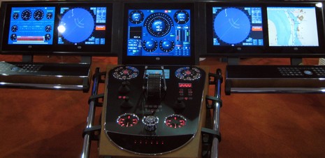
This is turning out to be a big year in marine electronics, particularly at the high end, and FLIBS is always a reminder of how high that end can be. I won’t argue with commenters who find the new NavNet 3D and G-Series expensive, but I might point them at something like this custom helm seen in the Super Yacht Tent. Check it out bigger here, and note the several translucent alarm-coded trackballs like the Palladium model I found in the same tent last year. Palladium, by the way, designed theirs from scratch and says it not related to the “Chameleon” hardware found at a German manufacturer. Whatever, these trackballs are a great idea. The helm, incidentally, was put together by Radio Zeeland DMP, and I have no idea what it cost.
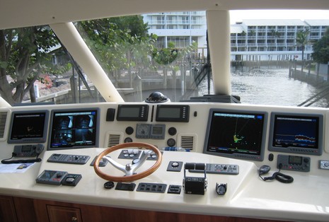
So much to gush about, so little time to gush. Yesterday I got on the water with a full-on Raymarine G-Series system—seen above, 4 monitors fed by 3 processors—and it truly is E-Series on steroids. The interface is E familiar yet nicely improved in some areas…and wicked fast. Plus we got to see Ray’s new high def radar, which was stunning. Then I attended the world premier of Furuno NavNet 3D, which is freaking amazing. It’s not NavNet of old, it’s not MaxSea; it’s something entirely new. The poor photo below was snapped as the Furuno guys replayed a trip recorded in the Cape Cod Canal, high def radar overlaid over an ENC vector that’s mixed with a high def photo map in a good way you’ve never seen before. The tabs at right are a smart new form of soft key driven by a “Rotokey”. I thought the interface, often demo'd live from a 3D black box unit, was incredibly sexy and ran charts faster and smoother than I’ve ever seen before, on any platform. Today much new dope is supposed to appear at both NavNet.com and Raymarine, which is good, because I gotta go.
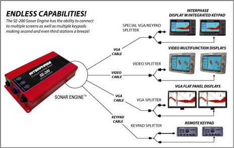
Now online along with my PMY column about George Wallner, owner of Electra, is a write up of Interphase’s neat black box SE-200B FLS (forward looking sonar). The two related as Wallner, like me, is a fan of FLS, despite its limitations, and had a series of Interphase models on his former yacht Tumblehome. An SE-200 could have integrated nicely into Electra’s two helm system, but Wallner chose a Color Twinscope instead, feeling that a stand-alone unit would be less distracting to use, which usually happens to be when he’s maneuvering in thin waters. Click here for pictures and details of Electra’s systems that couldn’t fit in the PMY article. Today, it was announced that the SE-200 made the DAME awards short list, one of 34 products selected from 138 entered. I don’t even know what some of the electronics category entries are! But I’ll be at METS to find out, assuming I get through the FLIBS mad house, which starts for me in one hour. As you can see from the press schedule and show list, I’m going to be a busy boy.
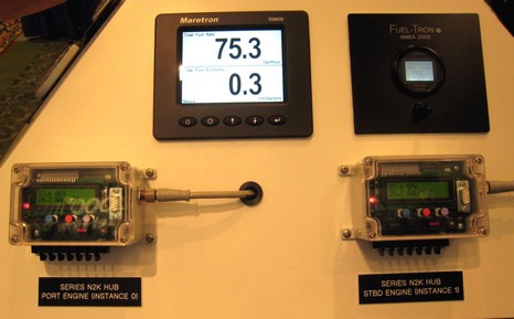
FloScan has been measuring fuel flow for over 30 years, so I’d guess they have a darn good idea how to do it. It’s refreshing that their new NMEA 2000 Diesel Monitoring System focuses on what they know well and let’s the resulting data go wherever you want. The flow sensors and those “hubs” seen above, bigger here, are all you need. Yes, you can buy FloScan’s round gauge upper right, but you don’t need to. All data is sent in standard N2K messages, and the little calibration needed is done right in those boxes. The rest of this NMEA Conference booth had Simrad, Lowrance, and Raymarine displays all showing the gallons per hour, remaining fuel, etc. Note that FloScan’s site says that, “Furuno is currently developing NMEA 2000 products which will interface with our system.” But we knew that, right, and will know more when NavNet #d debuts (hey, I might live blog it, if there’s WiFi there). Note, too, how the port engine is “Instance 0” in the N2K system and the starboard engine is set as “Instance 1”. You can set that with a switch in the hub. But who the heck decided to start instances at zero instead of one. Wouldn’t it be better if, say, GPS #1 was instance 1, GPS #2 instance 2, etc.?
I’ve long liked the concept of a handheld VHF with a built-in GPS and hence built-in DSC alarm capability (just add MMSI). I made the case here in August. So wasn’t I tickled to see this prototype kicking around the Lowrance booth at NMEA, and later to hear that Standard Horizon is also planning a combo unit. But it was very much a prototype, in fact just an empty shell, and Lowrance could not say when it will be ready. Ditto Standard Horizon. And the naysayers still report that the needed engineering is challenging.
Unlike last year, or last May, this morning’s GMDSS Task Force meeting seemed to yield good news about Class B AIS in the USA. The FCC has finally granted a waiver so that the various units already approved by the USCG can be sold and used even while further rulemaking takes place. The waiver needs to be reviewed by the Interdepartment Radio Advisory Committee (IRAC), but FCC representative Ghassan Khalek said that would be done in “a matter of weeks, not months”. And publication in the Federal Register will not be necessary; the moment IRAC grants its blessing, CG and FCC approved AIS B units can be sold and used. Why did I use the fudge word “seemed” in the first sentence? Well, a year ago Mr. Khalek told me that FCC Class B approval would be quick once the CG was done. So I double checked that “matter of weeks” quote with him as he exited the meeting. He nodded yes, smiled, and murmured a compliment about Panbo’s AIS coverage. Cool.
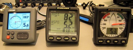
It’s a crappy picture, but this scene, bigger here, does give some sense of what Raymarine’s new ST70 instruments look like next to the brand new Furuno FI-50 series mentioned yesterday. The ST70’s look almost as good as the PR photography, but you can see that the screen is a little smaller than Furuno’s, which will also cost less (“about the price of ST 60s”, said the Furuno guys). The FI-50s aren’t at all graphic, but I thought the wind gauge with its “Formula 1 style” white face was very readable from a distance. There are three more FI-50 displays in that same style—close hauled wind, heading, and rudder angle. There’s also another digital display with one large data field, and the backlighting on all is automated and they draw little power as those are OLED screens. I fooled with the button controls and found the instruments easy to work, and that there are lots of data types supported. The picture, by the way, was taken at the Airmar booth and the NMEA 2000 wind data is coming from a new Weather Station model that outputs both N2K and 0183, has improved sensors, and will ship “this winter”. And the network could have included a new series of Simrad N2K instruments that look quite interesting. There’s much to learn about all these new instruments, but there’s little doubt that Furuno has done well on the N2K cabling front. Each of the FI-50 instruments has both male and female metal Device Net style connectors on the back, so they can be either tee’d from a backbone or daisy chained. Each also includes a switchable terminator so it can be set as the end of a backbone. Finally, seen below, Furuno has come up with an N2K cable box that can act as a backbone junction and 6 tees. This will be useful to an installer with tricky wire runs, a tight budget, or a burning need to strip wire. Oh, and the two wind instruments have a third connector for a new Furuno analog wind sensor whose data goes out as standard N2K PGNs, and the FI-50 brochure suggests that that Furuno will also be offering an N2K Weather Station and Depth/Speed/Temp triducer (no doubt Airmar’s). All good news, but possibly minor compared to NavNet 3D, debuting next Wed. night. By the way, Furuno is showing a bit more 3D leg here, and I like it.
NMEA 2000—able to bring tons of essential sensor data to a computer in an easy, standardized way—should be a huge opportunity for marine software developers. But there have been two major impediments. One is the lack of enough N2K networks to make its use worthwhile. That is going to change as more major manufacturers get seriously on board. For instance, tonight, when the NMEA Conference exhibition hall opens, I will get to see Furuno’s new range of N2K instruments (above) and also Airmar’s new high spec N2K/0183 GPS compass (yeehaa…and more on those soon). The other, particularly for small developers, is the substantial cost of getting a NMEA 2000 product certified. But I’m hearing about an impending NMEA initiative called “Intelligent Gateway” that sounds like it will largely take care of this problem. The concept is that a N2K gateway like Maretron´s USB100 can act as a firewall insuring that any software on the other side of it can not cause problems on the network, therefore minimizing certification cost. In fact, the plan is to offer a new NMEA 2000 PC “Approval” status for a measly $100. Any company could make and certify such a gateway and Maretron tells me that it might eventually make a second model that would be less expensive because it would not also offer NMEA 0183 translations. I’m hoping that all this means that small operations could, say, develop performance sailing software or conning screens using the same data that’s flowing to those new Furuno instruments…or who knows what! There’d still be an issue for small developers, though, which is the high cost of the documentation that details the NMEA 2000 standard messages. I get why NMEA charges a lot for certification—it finances the certification tool itself as well as the maintenance and ongoing development of the Standard. But I know I’m not the only person who thinks the whole excellent concept would move along faster if the documentation was freely available. I’m going to try and make that case to some of the folks who make these decisions, but could use your help. Please, if you have an interest, write a comment on this subject. Thanks!
PS, 10/20: Well, I didn’t really look at the documentation prices when I linked to that NMEA page above. They’ve been debundled, and NMEA makes a pretty good case that getting into N2K is feasible for even a small developer, especially now that some testing houses are able to do the certification. NMEA officials also told me that the Intelligent Gateway is for real, and Maretron just submitted the first gateway for final certification. The “Approval” cost will be more than $100 but hasn’t been set quite yet. At any rate a small software developer wanting to explore N2K might only need a Gateway, a $325 NMEA Trade membership, and the $495 electronic Database of PGN details to get started. More on this as I learn more.
Navionics just announced its new Platinum+ chart cards, which I got a peek at along the coast of Cape Cod last month. As the name implies Plus, or “+”, takes Platinum’s numerous features up a notch, or two. The top down photo maps and panoramic port photos are higher res, the bathy data underlying the 3D screens is more detailed, and the coastal pilots are more tightly integrated. I was particularly struck by the photo maps.
Ever seen this software before? Yup, that's the same touch screen navigation program that Maptech started developing as the Sea Ray Navigator (SRN) back in 2001, and also sold as part of its own i3 hardware system. Well, things have changed. You still can't buy the program by itself, but Captn Jack's is now offering Maptech Navigator Touch Screen, as it's called, bundled with a Motion tablet PC, and will soon also offer it on a Samsung UMPC (maybe the Q2?). I tried it on the Motion above (bigger picture here, and note that the tablet is inside a splash proof case), and found that it worked darn well with the stylus (though, as discussed recently, I think it will be even better when you can use either finger or stylus). In fact, damn slick with the included EMTAC Bluetooth GPS and non-marine software. (I also tried Maptech Navigator Pro on the tablet and, as fine a program as it is, I found it awkward to use with a stylus.)
Sorry about my acronym thing! The relatively new and unknown Alden AE-3300 is a black box wide band receiver with included PC software that lets you easily receive Weatherfax, Navtex, Telex, and even medium and high frequency DSC messages, besides listening to most any frequency between 9 KHz and 30 MHz. Hence in marine terms it’s pretty much an all in one receiver. Check the screen shot full size
. Not only did the AE-3300 automatically demodulate the Navtex messages and save them as text files when tuned to 518 KHz, you can schedule automated channel changes (as I have for Boston Fax at the bottom of the screen). I found the AE-3300 easier to use than the Icom PCR 2500 I’m also testing in terms of finding and saving interesting frequencies, but that’s in part because it has less controls that I’m unfamiliar with (but may be valuable). I also compared the radios using the same antenna and HAM signal, and they performed very similarly. What the Icom has, besides lots more frequencies, is all sorts of ways to scan them, a more sophisticated memory banking system, and a wide pool of users and accessories. There’s even alternate Bonito RadioCom control software that seems to do the marine Weatherfax, Navtex, and Telex decoding chores, plus some non marine radio wizardry I’d never hear of like SSTV.
I’m back in Maine briefly, which means I’m back to testing a couple of black box wideband radio receivers. And I mean WIDE. The Icom PCR2500 can tune in most anything from 10 kHz to 3300 MHz—less a few gaps like the cell phone bands (you have to be official to get that model). And I’ve got a pretty serious antenna strung from the peak of my house across the backyard. Some mornings I’ve heard participants in the Waterway Net at 7.268 MHz LSB, including some who seemed to be in the Chesapeake and one voice I’m pretty sure I recognized as Marti Brown, who was probably transmitting from her boat in Marathon, FL. But frankly I’m fairly rusty at marine single sideband use, and know zilch about amateur radio (HAM) usage. So if anyone has suggestions for interesting frequencies I might find signal on up here at 45N 67W, I’m all ears, so to speak. I’m also very interested in hearing from you boaters who are using HF transceivers or receivers now, or plan to when you head over the horizon in that dream boat. I’m about to write a column about PC-controlled receivers specifically and the use of SSB, HAM, Navtex, Weatherfax, cruising nets, etc. Thanks in advance for any and all input!
I felt bad about my harsh review of the AnyTrack monitoring device (and the inflated Sprint cell coverage that gives it Assisted GPS abilities). So I held on to the unit, and tried it again on a trip to Cape Cod, where it did pretty well. I also brought it to New York City, where I figured its claimed ability to determine location inside buildings would really shine. Well, not so much. The AnyTrack locator/transceiver and I are ensconced in my mom’s apartment at the corner of 16th St and 6th Ave (aka Avenue of the Americas), but time after time AnyTrack.net—full screen here —claims to locate the unit with “HIGH” accuracy at 84 5th Ave., which is quite a ways away if you were actually trying to find something in this dense urban environment. And that’s despite the fact that I’ve wandered the neighborhood with the unit in my pocket and set to 10 minute auto tracking, which it performed only so so. I can only conclude that this technology needs a lot of work.
I've been testing this PulseTech Xtreme Marine 12v “five-stage maintenance” charger for a month or so, and am impressed. What with Annie G's two batteries—one for the electric trolling motor, another for backup and electronics—plus some old batteries I’m trying to keep alive until someone buys Ralph, I’ve had plenty of material to work with. I really like how the Xtreme first tests a battery and then tells me with simple to understand LEDs what it’s up to as it goes through its multi step process. And while it’s impossible for me to really see the claimed desulphation process in action, the batteries certainly seemed very well charged. (Plus PulseTech has some scientific studies, using x-ray, that seem to back its claims). I was even able to use it to bring back a dead flat battery which someone around here had allowed to go completely dry; I did have to start the charge with a conventional “dumb” charger but the Xtreme (which first found it “bad”) took it from there and seemed to really perk it up. Charging a really low battery does take time, though, as the Xtreme only puts out 2.5 amps in bulk mode (5 amps claimed effective); hence the “maintenance” caveat. But you can just leave the charger attached to a battery indefinitely as it will stop charging and go into float/pulse mode when a battery is topped off. There are other pulse chargers and battery conditioners out there (a good explanation of charging, pulsing, and desulphation here), but Xtreme seems like a winner.
The truth is I sometimes use Panbo myself as a sort of diary of where I’ve been and what I was up to, at least in the boating/electronics portion of my life. So I’m sticking up this photo a friend (thanks, Howard!) took last Thursday evening. It was amazingly warm—I sailed until after sunset in just a t-shirt—but the signs of Fall are there…the changing leaves, the schooners getting decommissioned and prepped for shrink wrap. (And, by the way, for your sense of Camden geography that tower on Mt. Battie is where I take Panbo’s header photos.) So I hauled Annie G. yesterday, not just because the season is winding down, but because I’ll be on the road for a while. First a week in NYC visiting the boat’s namesake, me mum, who’s fetched up on one those medical shoals of old age. Then back here briefly, then NMEA conference on Amelia Island, FL, back to NYC, and finally to FLIBS. I’ve got tons of material for Panbo posts, but some days may not get around to it. If you live where there’s a real winter, get some last boat rides in!
Check out the full size screen shot. I took it here at my desk while designing a custom screen for Maretron’s N2KView monitoring and control application. I was picturing myself the master of a high-end cruiser putting together the screen I’d like to have accessible anywhere on the boat—and off it—when anchored. Which is completely possible, given the concept at work here. In fact, the data you see is real stuff coming out the lab’s NMEA 2000 network, through a Maretron USB Gateway into the lab laptop where it’s being packetized and served into my home network, in this case via WiFi. Zounds!
I’m not sure what Raymarine’s rational is for creating its own proprietary NMEA 2000 cabling system, though I’ve been studying the brochures and manuals available (on Ray’s nicely updated site). Aside from the small diameter (11mm) of the connectors, the features touted in the ST70 brochure—“rugged and waterproof”, “quick and easy” install, etc.—are similar to the DeviceNet cabling NMEA tried to impose as a standard physical layer.
In addition to the tank/rudder adapters I tried, Maretron sent over some new cabling parts of interest. Let’s check out the big picture, starting with the four way tee at lower right. It’s quite like the Double T that Lowrance recently introduced—though obviously better made (metal threads!), and probably more expensive—and it’s obviously useful in tight areas where you want to tee off numerous sensors and/or displays. To its left is a possibly more valuable inline terminator.
I recently added tank level and rudder angle info to the lab’s NMEA 2000 network. In both cases this involved wiring a Maretron Adapter to a standard analog sensor. N2K skeptics will no doubt gleefully point out that the two sensors—a VDO for the rudder, and a Teleflex for the tank—together cost about half the $195 list price for either the Rudder and Tank Adapter! But consider what I got in terms of a bigger boat system.
Thanks to Richard’s sleuthy comments to the earlier G Series entry, here are some low res images of various G Series system components beyond the monitors. They’re snitched from an online price list (PDF) put up by French Raymarine distributer SD Marine. The text is in French, and not detailed, but I gather that the “Processeur” GPM400 above has a hard disk pre-loaded with Navionics Platinum charts for one large region—you choose U.S., Europe, or ROW (rest of world)—and Gold charts for the others. It also has dual DVI monitor outputs (1280x1024 pixel), two NMEA 0183 i/o ports, a SeaTalkNG/N2K port, and a 100mb SeaTalkHS/Ethernet port.