Panbo

July 2007 Archives

Swift Hitch, first viewing

Jul 31, 2007

SwiftHitch_test_cPanbo

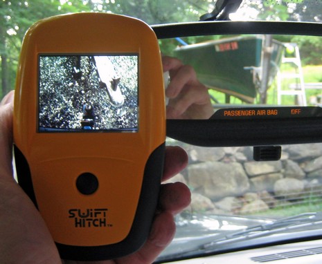
So a friend of mine recently returned from the Upper East Side of Manhattan reporting a New Yorker cartoon seen live: A madame parking her large and shiny SUV while getting backing directions from a lady friend stationed on the sidewalk via cell phone! No wonder there’s a Web site for rear-view cameras. Which, in fact, quite likes this portable Swift Hitch device. I’m fairly impressed too. It was just a matter of installing the li-ion battery in the display, charging it and the camera’s built-in battery with the dual 12v charger before I turned them both on and—lights, action!—everything worked fine. Hitting the main button reverses the image, which is helpful when also using the rear view mirrors, like above. I also tried it in the dark and the automatic infrared lights came right to life (the image goes to grey scale then, but is usually color, if not exactly rich color).

Continue Reading

Krill SS BB PC, N2K too

Jul 30, 2007

Casey_Cox_Krill_cPanbo

Krill Systems just announced its solid state (SS), black box (BB), marine PC, which means I get to drag out this shot of Casey Cox mugging with it at my kitchen table in June. The box uses a flash disk drive and embedded Windows XP for 24/7 reliability with a current draw of only 55 watts. It’s meant to run Krill’s monitoring software exclusively (though it’s powerful enough to run other applications, and Cox said that he’s willing to talk with developers who might have an appropriate, and rock solid, co-use for it).

Continue Reading

Camden Harbor Master, WTF

Jul 28, 2007

Camden_Harbormaster_Contest_cPanbo

We haven’t had any “weekend weirdness” or contests for a while, and this seems so right. That’s Camden’s ever enthusiastic Harbor Master Steve Pixley holding up his recent invention. Your challenge is to figure out what its purpose is and why it might be valuable to certain boaters. Give us your best guess in the comments section. I’ll either confirm a winner, or explain the gizmo on Monday. The prize, per usual, is a free subscription to Panbo ;-)

7/30: OK, maybe I was misleading…the “certain boaters” I meant above are all the mooring installers and inspectors who may save time and fingers with Steve’s “Harbormaster” tool. Instead of having to haul up mooring chain one section at a time, the tool let’s them grab it just about anywhere they want, as surmised by Terry, and shown in video here. Congrats to Terry, and Steve, and thanks for all the…um…creative guesses. Whoever handles moorings in your harbor may appreciate learning about www.harbormastertool.com.

On SoZ with Bruce, & FUBAR

Jul 27, 2007

SoZ Camden cPanbo

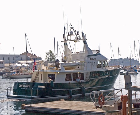
Darn, I was hoping to get a shot of Bruce Kessler in his wheelhouse departing the Camden Public Landing this morning, but got distracted by a contest idea (that you’ll find here this weekend). When I looked up, he and his all-ladies-of-a-certain-age crew were headed out into the haze. You may still be able to catch Spirit of Zopilote at Shine Micro’s Live AIS, which, as shown below, can now overlay on Google Earth  (and shows Penobscot Bay thanks to the Penobscot Pilots). I really enjoyed meeting Bruce last summer, but my admiration is up a few notches further after a couple of coffee-sipping hours with him this morning.

Continue Reading

Bebi LEDs, from Fiji yet

Jul 26, 2007

Bebi_Beka_Light

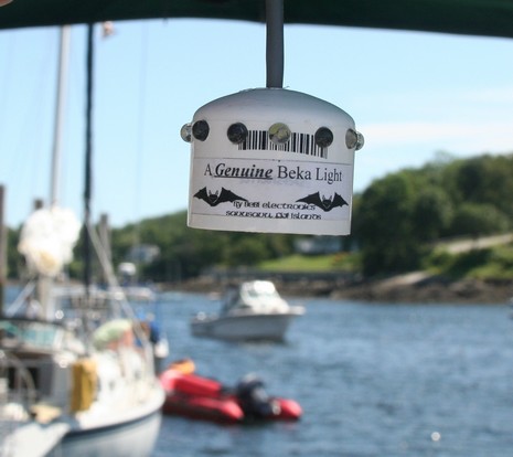
Bebi Electronic’s LED lights most likely don’t employ the latest technology, like touch dimming, but there’s a lot to like about them. The company purportedly provides clean work for folks living in the village of Nakabo, Fiji, which is about 40 kilometers from the nearest power line. Bebi has all sorts of styles, including units that can be used for running and anchor lights, and prices seem quite reasonable. This Beka style cockpit light, for instance, is cleverly housed in a PVC pipe cap and only costs $36.50. I saw it last summer hanging aboard Dan Gingras’s Lionheart (thanks, Dan!).

Hella red/white LED, touch dimming too

Jul 26, 2007

Hella EuroLED touch

Neato! Touch the red button on this new Hella Marine EuroLEDTouch dome light, and you get red light; hold your finger there for two seconds and it will cycle through four dimming levels. The white button gets you white light, and your preferred dimming level is remembered for each color until you do the two second thing again. The dome is 5” across, 1.2” deep, completely waterproof, retails at $180, and can be had with a black shroud instead of the white shown. Hella doesn’t claim any sort of brightness equivalency for this LED fixture, unlike, say, Sailor’s Solutions 10–watt-halogen claim for its Sensibulb. I dare guess that Hella is using up-to-date LED technology, but I have learned that all LEDs are not the same, by any means. Maybe I can get one of these to test alongside the new version Sensibulb that’s headed this way.

Boatsense revisited, works good

Jul 25, 2007

Boatsense_Test_cPanbo

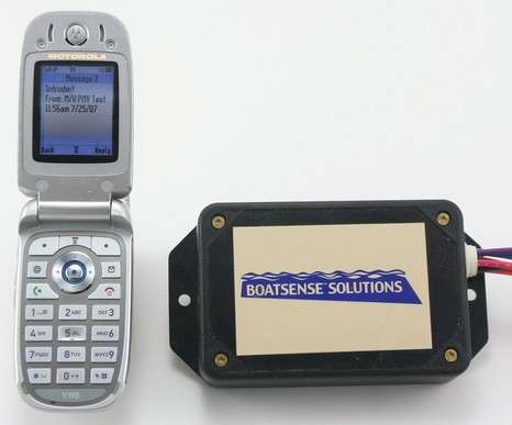
Hot and humid in Maine, a good chance to hang in the lab with the Boatsense Solutions remote monitoring system I’ve been meaning to test further and photograph. Today I learned to program it so it will send the particular message you might want depending on the particular sensors you’ve hooked to the three auxiliary inputs. You have to get the syntax right, but once I sent the text message “#AM3Intruder!” to the monitor’s phone number, then broke the connection between the Aux #3 wire and ground, the unit called me with the “Intruder!” message above.

Continue Reading

Yamaha Command Link, NMEA 2000 or not?

Jul 24, 2007

Yamaha Command Link

Yesterday commenter JC asked how to connect his new Yamaha F250 to a Garmin 5212. The answer is a little less definite than I thought. I certainly remember Yamaha talking about how their coming CANbus engine system, Command Link, would be NMEA 2000 compatible—can even find a company reference as recent as last year—but check out the official Command Link Web pages, and see if you can find a single mention of NMEA 2000! Strange.

Continue Reading

Garmin 3D AIS, & an 0183 issue

Jul 23, 2007

Garmin_AIS_cPanbo

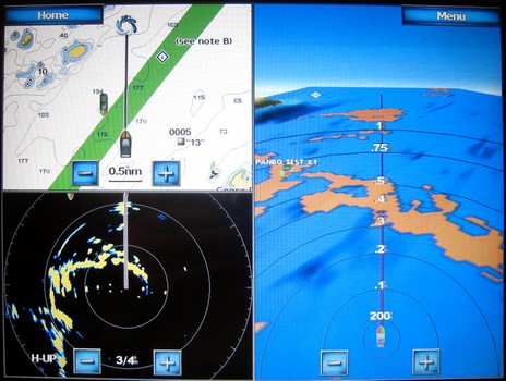
Not one of my better pictures, but the bigger version here will give you some sense of how the Garmin 4– and 5000 Series handle AIS targets. At upper left you can see the AIS target on a the regular 2D chart; my first impression is that the icon representation may in some situations be a bit too busy compared to a standard AIS triangle. But I do rather like the 3D target representation in the Mariner’s Eye 3D view (sorry it’s a bit indistinct; I’m going to have do videos of this stuff at some point). You can also see the target icon just showing on the radar screen (which also gives you a reference to how the 3D radar overlay looks in 2D).

Continue Reading

The Panbo lab, show business!

Jul 20, 2007

Propeller_Beanie_cPanbo

Oh my! Or maybe “Ole!” as I’m posed like some sort of honky flamenco dancer. Actually I was trying to get the propeller beanie spinning with my left hand while I took the photo with my right. I once teased about the lab coat, and today can reveal its purpose…an August PMY column opening with a less demented version of this shot and describing the setup of what I dubbed the “Marine Electronics Performance and Interface Testing Facility.”

Continue Reading

Bird zapper, a test undone

Jul 19, 2007

Bird_zapper

I’ve had a rotten day, and maybe you too could use a laugh (aside from the must-see “big ass table” video JT brought to comments). The other day I found the prototype above under a few years of dust in a remote nook of the lab, never tested or returned. Its goal is to disuade birds from perching on your spreaders and leaving a mess, and to do so it converts small quantities of 12v DC into 8,000–15,000 volt DC 600 HZ current. Don’t ask me how, but I was told that the resulting zaps are very effective at avian behaviour modification! However, though the developer has had a string of hit products since, this one never came to market. I’m guessing for the same reasons I somehow never got around to plugging it in, a behaviour I’m rarely guilty of. (I am often slow returning things, but this is a record.)

Garmin 5212, sexy time!

Jul 18, 2007

Garmin 5000 Mariner 3D mode cPanbo lr

Um, speaking of 3D (and one very funny man), I just unpacked and powered up a 5212 and…wow! On first impression I’d say its touch screen control is as smooth and responsive as Maptech’s latest i3 (and that’s saying something). And weren’t there some nice surprises during my first hour. I’m not sure I’m ready to navigate without spot soundings, but Garmin’s Mariner’s Eye 3D (g2 Vision card required) is darn close. Note, bigger picture here, how you can specify hot colors for the hazardous areas. (The ledges at about .4 miles, two o’clock, should show hotter, but maybe that’s just a local glitch. Will check.) Note too the yellow botches of radar overlay; they’re just a simulation here but I’d sure like to see how they work in reality. (I was monitoring VHF as I tested this unit in the lab. Maine’s blanketed in a dungeon fog this evening, but AIS shows the Cat still doing almost 40 knots offshore; it’s hairy out there!). But what really surprised me is that the two lit navigation aids to Camden were graphically showing their characteristics in this 3D mode (see the green dot over Curtis Island to port). I didn’t even know Garmin had “borrowed” that C-Map Max feature. Now all this may apply to Mariner’s 3D on every new Garmin unit, but the screen below certainly doesn’t. Note the very large touch keys, and note how they’re grayed out when they don’t apply to a particular data field. So easy to use; so sexy time!

Garmin_5000_keyboard_cPanbo

Surface and multi-touch charting, oh yeah

Jul 17, 2007

Perceptive_pixel

Continuing on about how we’ve just gotten started with electronic cartography, check out the demo video at Perceptive Pixel showing the developers exercising two handed control over Google Earth and other imagery. Then there’s Microsoft’s new “Surface Computing”—also “multi touch”—nicely presented by Popular Mechanics on this video. It sure seems possible that the ‘surface’ could be one wizbang chart table…eventually. Meanwhile, Google has introduced Maplets, which means that users can now contribute mini applications as well as content. And Michael “heywhatsthat” Kosowsky has already created three, two of which I used in the mashup below (and bigger here). One very usefully overlays Michael’s topo lines and the other guesstimates new shorelines if sea level rises. Just add 150 feet and I’ve got waterfront!

Waterfrontatlast_cPanbo

PS 7/18: “…a quantum leap from our 2d/3d apps like Google Earth”? Check out this video about Seadragon and Photosynth (thanks, John!).

Garmin NMEA 2000, good news!

Jul 17, 2007

Garmin_4212_digital_engine_cPanbo

I had a long phone interview with Garmin this morning and was mucho pleased to learn that the limited NMEA 2000 support in the 4 and 5000 series is only temporary. Garmin’s Marine Sales Manager Greg DeVries explained that the reason they took the approach they did—i.e. N2K engines only, as seen in the (simulated) screen above and its alternate—is that they’d “still be in development” if they hadn’t. He promised that “Going forward, we're absolutely going to embrace full NMEA 2000. It will just be a software upgrade for existing customers.” That makes what I first heard sit a whole lot better!

PAS-Thru Box, a NMEA 0183 necessity?

Jul 16, 2007

PAS-Thru_Box_cPanbo

I first heard about it at NavaGear, immediately contacted developer Paul Shirley about a sample, and now am an extremely pleased PAS-Thru Box user. You may already have read my whining about NMEA 0183 wiring difficulties. Many boats these days are spider-webbed with fine gauge wires carrying important data; they’re painful to install and often end up way too vulnerable to damage, not to mention poorly documented and hard to modify. Well, I don’t know how the Box could do more to remedy these problems. Those orange spring tabs above (bigger photo here) are powerful and purportedly gas tight.

Continue Reading

Waterproof cameras, and gadget lust

Jul 13, 2007

Sanyo Xacti E1In today’s New York Times, the inexhaustible David Pogue reviews three waterproof digital cameras—the Olympus Stylus 770 SW, the Pentax Optio W30, and this Sanyo Xacti E1. Now the first two are not exactly brand new. In fact, I tested the Olympus over a year ago. Then I actually purchased the Pentax last November. Contrary to Pogue’s conclusions, I liked the Pentax much better, mainly because I think it takes much sharper pictures. Still, I ended up gifting it to my daughter and buying a Canon PowerShot SD800 IS (as foreshadowed in that entry). This little camera I adore, and you’ve seen the results in many recent Panbo entries. It takes amazingly good video too. But its not waterproof, and now, damn it, Pogue reports that the truly new Sanyo Xacti, which is primarily designed as a video camera (spec page here), takes better stills than both the Olympus and the Pentax! By the way, aside from the wonderous Woot, I pretty much satisfy my gadget habit at Amazon these days. It’s hard to find a better combination of ease, service, and price. Plus Panbo is an “Associate”. Which means that if you need one of these cameras, and of course you do, please generate a commission for Panbo by using the link below to buy it. Thanks!

Sanyo Xacti VPC-E1
Canon PowerShot SD800 IS
Pentax Optio W30
Olympus Stylus 770 SW

KVH TP V7, big news for big boats

Jul 12, 2007

KVH_TPV7_diagram

Game change! This morning KVH announced the TracPhone V7, a marine VSAT system capable of delivering truly broadband Internet, including telephone (VOIP), KVH_TPV7_size_graphicto big-budget yachts cruising much of the Americas and Europe (including transatlantic, see below). But you don’t need a mega-size platform for the V7’s dome, which is an astounding 85% smaller than what it currently takes to get this level of service (and 65% smaller than slower Inmarsat Fleet 77 domes). Hence the “mini-VSAT Broadband” name for the associated satellite service, whose costs are also said to be radically smaller than existing offerings. For instance, the per megabyte price at 512Kbps-up/1024–down is $5 versus $32 for Inmarsat’s 128/128 F77 service, and there are various bundles and monthly plans that bring it down further.

Continue Reading

Charts etc., we've just gotten started

Jul 11, 2007

Google_Earth_south_up_cPanbo

Pardon a slightly meta sidetrack, but two bits of the massive media flow got my attention. One is a Wired article about Google Earth which makes the case that the future of cartography is user data. “We're all mapmakers now, which means geography has entered the complex free-for-all of the information age, where ever-more-sophisticated technology is better able to reflect the world's rich, chaotic complexity.” Then there’s the news that scientists have calculated that the diameter of the globe is about 5 millimeters less than thought. Not even a quarter of an inch! Among other techniques, they used atomic clocks, quasars, and 70 radio telescopes to establish base lines, and they say that the precision they are after will help to better measure phenomenon like global warming, ocean currents, and tides. As amazed as most of are by all the information now available on a yacht’s bridge, I think we’ve just gotten started. (For some really interesting dope about related planet dimensions, and early cartography, check the beginning chapters of Nigel Calder’s How to read a nautical chart, which also has practical uses!) 

PS 7/12: It turns out that Captain Richard Rodriguez, who has a thing or two to say about the Boston ferry collision (see his fine blog), has also used Google Maps to mark the most frequently hit rocks in the San Juan Islands. What I’m talking about!

Boston ferries collide, lack of AIS?

Jul 11, 2007

MBTA ferries collide

Interesting that an intrepid Boston Globe reporter figured out that AIS transponders might have prevented two Boston ferries from hitting each other in thick fog yesterday morning. This is the sort of thing that promotes public awareness of a valuable safety technology, and perhaps will encourage the FCC, USCG, etc. to move expeditiously on approving Class B and mandating its use on such vessels (or argue that Class A is worth the cost). On the other hand, operator error can not be ignored. Heck, these two boats both work for the MBTA. Wouldn’t you think that they’d know where each other was and be in VHF contact? Not that we all aren’t capable of mistakes. I’ve often thought that running ferries must be a particularly hard gig as the tendency to get lax must be major. (Thanks for the head’s up to Doran, who can, on a good day, float you over bustling Boston Harbor.)

Nauticast B, the hardware

Jul 10, 2007

ACR_NauticastB_antenna_frig_cPanbo

Apologies to ACR and Visions of Johanna! But here’s how I used duct tape and hose clamps, those old quickie install standbys—plus a new favorite, velcro tape—to marry the Nauticast B’s AIS tuned VHF antenna with its GPS antenna so I could secure both with a single rail mount. The antenna duo are not as compact or elegant as Y-tronic’s combo, but they seemed to work well. It’s also worth noting that while both come included in ACR’s $1,180 kit (still not approved for sale in the U.S.), you can use your own GPS source or your own VHF antenna (and you’ll find that the Nauticast B’s PL258 VHF connector is more the norm in the U.S. than the BNC type).

Continue Reading

Gar & Ray 5" fish finding, first impressions

Jul 9, 2007

RayA60_Garmin545s_sonar_cPanbo

I got the test Garmin 545s and a new Raymarine A60 installed on Gizmo and took a test run around my local Lake Megunticook. I don’t think Navionics, Garmin, or any one else has electronic charts for this particular lake—or many lakes in Maine for that matter—so the plotter functions were pretty pointless. But I did get a taste of both their dual-frequency fishfinders. For starters I was rather shocked that neither seemed to interfere with the other, even when both were set to the same frequency, and even though the transducers are about 6” apart on the transom. They simultaneously held onto the bottom even at 20 knots too. Is this an aspect of the digital signal processing both claim to use?

Continue Reading

Lowrance NMEA 2000, going red

Jul 6, 2007

Lowrance N2K Red

Cool. Not only has Lowrance switched to standard style N2K screw connectors, but they’ve also added the nifty Double T fitting seen above, and they seem to be emphasizing NMEA 2000’s name and multi-manufacturer compatibility over “LowranceNet” in their new marketing (and, if interested, don’t miss their new PDF on the general N2K subject). To clarify, all new Lowrance connectors/cabling with red accents can plug directly to any standard NMEA 2000 device, which includes all of Maretron’s offerings, a few larger Garmins, and now all sorts of Lowrance displays and sensors. A simple patch cable will be needed to network with older blue-accented LowranceNet devices and/or cabling, or to Raymarine’s SeaTalk2, SimNet, etc. Apparently Lowrance’s cabling is not yet NMEA certified, but apparently that’s not stopping folks from using it beyond Lowrance gear. It sounds here like “yachtjim” used it to interface a Suzuki 250 outboard to a Garmin 5212 (guess they’re shipping now). He’s quite happy with the engine screens on the Garmin, but warns that since the Garmin doesn’t output any NMEA 2000 data, it won’t help do fuel calculations on his Lowrance LMF instruments. I’m just about to get back to my Garmin testing, by the way. And, finally, a Thanks! to Salvador Castellá for the head’s up about Lowrance updates. He works for the Spanish company Albatross Control Systems, which handles just about everyone’s NMEA 2000 gear under the Alba brand plus makes its own analog-to-N2K converters plus a system for collecting it on a computer and even sending it ashore.

Real world AIS B #3, jumping bean plots

Jul 5, 2007

AISB_Spirit_Bermuda_cPanbo crop

So somehow when I was actually plotting Spirit of Bermuda’s Class B AIS output in Hamilton Harbor my screen shots failed to save. But I still have the marks I made every time its plot updated and you can sort of see the jumping bean effect that results from Class B’s 30 second update rate. I connected them with route lines so you can get a better sense of scale, bigger here. As discussed earlier, a 30 knot boat is going to plot every .25 nautical miles; Spirit at 9 knots plotted at about .07 mile increments. It was a little disconcerting, especially when she made large course changes rounding up to a pier. (And, by the way, would have been twice as bad if I had been using a single-channel-at-a-time receiver). But, again, I still think Class B is valuable regardless, plus I figure some smart developer(s) is going to figure out a way to dead reckon these targets in a way that’s not confusing.
   Finally, small world department, Spirit was built only a few miles from Panbo HQ at Rockport Marine, and we watched her launch from the bridge of Shanghai Baby last August, as noted in an article just published in PMY.

Cell data rules, scary

Jul 4, 2007

Motorola_Cell_Modem_c_Panbo

My latest PMY electronics column, “Connected Cruising”, is now online and here’s a full size version of the screen shot I used to illustrate a successful online cell phone venture using Motorola’s Phone Tools software. A PMY forum comment from Robert Stronger adds some interesting detail to this story:

Continue Reading

Electra, Lyman-Morse on a roll

Jul 3, 2007

Electra_helm_cPanbo

Despite indications that I only think about AIS, I do have some other subjects! A big one recently has been Lyman-Morse Boatbuilding. This morning I just finished up a PMY Sept. feature about the company’s woodworking department—now 50 crafts-people strong, and doing phenomenal work—and I’m researching an eventual electronics column about Electra, which began with an early June trail run. What a boat! You can actually feel her lightness (carbon laminates, cored panels, etc.) as she gets up and cruises in the mid 20 knot range with a relatively minor wake. And what a helm! It’s unfinished and undressed in this shot, bigger here, but you can sense the excellent sight lines, both outside and to the various screens.

Continue Reading

Real world AIS B #2, the name game

Jul 2, 2007

AIS_B_Link2AIS_cPanbo crop

What luck that I got to monitor another active Class B transponder while testing one myself. As you can see above, and bigger in my first Nauticast B post, ACR’s included “Link2AIS Class-B” software identified the training ship Spirit of Bermuda’s AIS as a B model. Coastal Explorer did not make this distinction but it did decipher Spirit’s name and other “static” information. As mentioned in my one offshore post, none of the five ships I spoke with were getting our name on their Class A AIS displays, though they could see our MMSI, position, speed, and heading. We’ve discussed this issue before, and I’ve written about it in several magazines (Professional Mariner most recently), but let’s review:

Continue Reading