So I rarely discuss dimensions and weights when I write up electronics, figuring that it’s fairly obvious, or at least easy enough to find on the manufacturer’s Web site. But the latter is not always true, and some products just don’t look their true size, even when pictured with a little context. For instance, when I first saw a photo of Y-Tronic’s dual antenna AIS accessory, my eye failed to see how petite it actually is, even though the plugs are familiar. (And I still don’t understand how it mounts on a rail, though I’ve got the question in). Nor did I get how chunky the Lowrance iWay 600c is from its first photo. I’ve come to like the thing quite a bit, but shoppers should know that it weighs about 2.6 pounds with the accessories below (bigger here), and the AC brick is a whopping 1.6 pounds more. The weights are not given at Lowrance.com (that I can find), but the manual does wisely recommend resting the unit on a dashboard so that the suction mount doesn’t take the whole strain. By the way, I’m quite enjoying my new photo set up, above, but an explanation of the lab coat will have to wait a while!
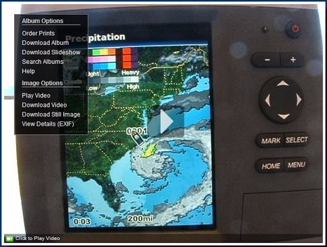
I’ve been feeling mighty guilty about my oh-so-slow testing of the borrowed Garmin 545. So it was particularly great to find that a fisherman named Tom has posted a useful series of stills and videos illustrating many 545 features. His Bluewaterpirates Phanfare album may be called “XM Music Functionality” but you’ll find dope on the new Vision charts plus a nice “new section” showing all the XM weather functions using a dramatic offshore low, and more. Enjoy.
I’m working on a Voyaging profile of Milt Baker’s Bluewater helm, which makes it particularly propitious that he and Judy are this minute sheparding a fleet of nine Nordhavns convoying to Bermuda from Ft. Lauderdale. Three, including Bluewater, will continue on to the Med, hence the rally name Med Bound 2007. There are supposed to be daily updates accessible from this Web page, but the fleet’s Yahoo group seems more current right now. But I’m also getting Milt’s email noon reports, which yesterday included some rhapsodic words on AIS. Six of the nine boats have Class A transponders (Bluewater a Furuno FA150), which is making it easy for Milt to monitor the convoy, and passing ships to understand what’s going on. Milt, by the way, is using OCENS Mail with an Iridium phone to e-mail from offshore (but note that Globalstar announced today that it just got four replacement birds up, which should improve its service situation). Note too that while Milt generally uses high end gear—with backups for the backups!—he’s also the guy who questions the need for big radar scanners. Which brings me to the picture above. That’s Milt showing me how he deals with a drawback of using conventional, if inexpensive, monitors on a bridge. The 15” View-Sonic LCDs can’t dim down enough for night running, but Milt took care of that with some sticky back hook-and-loop and red gel. Now, what I just noticed in these photos, and can’t find on the Net (or ask Milt about right now), is that odd doodad next to the compass. I have a feeling that it’s some sort of nav aid reminder—and no doubt useful if Milt’s got one—but how exactly does a Marker Mate work?
Today Garmin announced a slew of new tools meant to encourage third parties—commercial and otherwise—to interact every which way with Garmin hardware. I’m not a developer, but my quick read suggests that possibilities include writing a cell phone app that’ll get location from a Garmin GPS via Bluetooth; equipping a Web site with an easy way to up/down-load waypoints, routes, and tracks; creating a set of “Garmin Rich POIs” (GPI) from raw XML or GPX files; and more. In fact, it looks like Garmin is going to share some of the sophisticated software goodies it acquired with Motion Based, figuring, I guess, that even if other developers make something good enough to command subscriptions, Garmin will still get the hardware sales. But like I say I don’t really understand all the developer talk. So I’m hoping that those of you who do will check out the new site and report back.
Thanks to gCaptain for leading me to the Flickr pages of a Houston ship pilot who is also a fine photographer. Unfortunately he doesn’t aim his camera around the bridges much, excepting a few like this shot of a Turkish captain (is that a periscope in front of the helmsman?). But, wow, his marine sets are sure worth browsing (don’t miss his “Darwin Award”).
Wasn’t I tickled to discover that what looks like a fairly simple and affordable new remote boat monitoring device is being made right here in Maine. And further tickled when Boatsense Solutions cofounder David Jacques zipped right up and explained more about what’s in that little bomb-proof (epoxy potted) box…i.e., more than explained in the so far rudimentary brochure and manual. And tickled even more when I fired up a test unit last night, taught it my phone number, and successfully simulated a high bilge alarm, all in a few minutes. Boatsense is a GSM cellular modem set up so it can send text messages wherever GPRS data service is available (much of the world). It monitors battery level with just its power feed, plus has an input for most any kind of bilge alarm switch, and three more for whatever sensors you want to add (including output from an existing on-board monitoring system). That’s it; no screen, no GPS, no Web page…but it’s only $499 list and $180 per year for up to 20 messages a month (extras 10 cents each). Distributing partner Hamilton Marine has a package deal here, and if you do a search on “boatsense” there you’ll find a selection of sensor options. I’m going to test this baby more on Gizmo (wished I’d had it last July, rigged with a magnetic motion switch), but I’m pretty sure that it’s well thought out and may well be a winner.
OK, it wasn’t the smartest move, me trying to jam the cable back into a very funky old external antenna while the Garmin 545s it was attached to was still running. Apparently I shorted the cable because, surprise, the Garmin beeped and told me so! I can’t say that I’ve tried this on any other GPS, but doubt I’d get such an informative reaction. One more check on the smart interface list.
Sometimes I like to wander around the many sites of one Stephen K. Roberts, a gent who appears to be a true original. Robert’s latest ride is the Corsair 36 trimaran Nomadness, which must feel like a megayacht after the Microship. It was on his photo tour of Nomadness where I saw this shot of a RadioLabs 12db steerable WiFi antenna, called a Wi-Pod, which Roberts calls his “secret weapon”. His current project seems to be a “pedal/paddle/sail kayak” tender for the tri, a replacement for Bubba, and featuring something he calls Kayaktopus:
At first glance, this may sound just a bit excessive... after all, I'm the guy who built the BEHEMOTHbicycle, an existence proof of the Roberts Law of Applied Mobile Gizmology: "If you take an infinite number of very light things and put them together, they become infinitely heavy." I have occasionally been accused, with some justification, of over-engineering.
Tip of the hat to Mr. Roberts for exploring the geek frontier, with a sense of humor.
I’m getting to know the new Garmins slowly but surely, and one of the many things I like is the way choices you don’t actually have aren’t there to confuse you. For instance, if you start one without the transducer attached those “Sonar” and “Chart/Sonar” buttons on the Home menu above just aren’t there. Similarly, if you go into the Charts menu below without a g2 Vision card in the slot (nifty magnetic latch door, by the way), your choices will only be “Navigation Chart”, “Mariner’s Eye”, and “Chart Setup”. The interface is smart like that pretty much everywhere. In fact, I’d recommend learning this machine first without a card even if you get one with it (assuming you get a unit with built-in charts). But you may very well want to use a card eventually. Garmin has done well at making these MFDs quite good as is, but then piling so many more goodies (like those Fishing screens) into the cards that you’ll be truly tempted. But at least they don’t rub the features you don’t have in your face. Now, do you notice anything different about the photo below? I finally sprung for some decent lights and a soft box, and these are my first shots. A bigger crop of the image below is pretty darn close to what the screen and the interesting flecked casing actually look like. And the images should get better still as I learn the gear.
OK, I’m grumpy, and don’t feel like thinking about electronics. Late on a deadline, in all day when the weather’s gorgeous, it happens. Plus I’m still sour that I’m not megayachting in Cannes, especially now that Proteus showed up there. You may have seen shots of this wacky catamaran when it mysteriously appeared in San Francisco Bay. Later I found the site of Ugo Conti’s Marine Advanced Research, where you can download an enormous .mov movie of this baby in motion. Actually, you may need to go through the press registration, but the video really tells the tale. Proteus is a WAM-V, or Wave Adaptive Modular Vessel. Those are gigantic hinges and springs attached to that inflatable hull. Even the drives articulate. In motion the damn thing undulates like a movie starlet slipping off a slithery dress. Electronics seem to be by Raymarine, but isn’t the real question that backwards prop behind the pod? (Hint: “Modular”). Hey, wouldn’t you be grinning too.
My June PMY column about Faria’s do-it-all PC-based Maestro helm system is now online, along with write-ups of the ACR ResQFix PLB, McMurdo SmartFind EPIRB, Icom M34 handheld VHF, and Cobra 425 handheld (I know, the picture is of the F80; we’ll fix it). Maestro is quite a system, and I’m glad that Faria now has dope about it on their Web site (online marketing is not the company’s forte, but they have strong relationships with lots of boatbuilders, which may be more important in the case of Maestro). Bigger here is the collage below which I made to illustrate some of Maestro’s connectivity. I believe the finished version also has a PCMCIA card slot on the back, meant for a cellular data card. Also online are all four of PMY’s June electronics features, including my take on ideal systems (which some of you contributed to back in March). The piece got titled “Perfect Picks” though of course they’re not, which I’ll probably be hearing about from manufacturers at any moment! Meanwhile some of you have asked about PMY’s sale to the “supermarket mogul” Ron Burkle. Well, rumor has it that we may be included in a secondary sale to some other publishing conglomerate, and, besides, we’re doing fine…in short, “business as usual”. In fact I’m writing my 73rd straight monthly column right now. Year seven at PMY begins.
Geez, call it my American arrogance, but I really thought Larry Ellison’s America’s Cup team was a contender. But I haven’t been paying much attention, and it looks like BMW Oracle Racing may lose the semi-finals today, especially as Ellison (no relation) apparently fired skipper/helmsman Chris Dickson before today’s race. There are video clips and breaking news at cupinfo.com, and Kimball Livingston is blogging the cup here, very well I think.
PS. Yup, the U.S. team is done; no Cup in San Francisco anytime soon, I guess. I dug around for some dope on BMW Oracle’s—or any IACC boat’s—electronics, but only found this vaugeness. What the hell are all those aft antennas (seen in this Gilles Martin-Raget photo)? Anyone?
Big thanks to John G. for a head’s up about the MAIB’s recent report called “Performance Investigation of Marine Radar Reflectors on the Market.” The full PDF is available on this page, along with a typically MAIB meticulous report on the tragic sinking that prompted it. Three sailors died after the big ferry Pride of Balboa apparently ran down the 26' yacht Ouzo early one morning near the Isle of Wight. At any rate, the graph above plots the average Radar Cross Sections of most available reflectors. You won't like those results once you understand them. The testers concluded that only the Sea-Me active reflector delivers a strong enough radar return to even meet the ISO 8729 standard, and some perform so poorly that they aren't worth carrying because they'll only give skippers a false sense of security! None of this real news; in fact I discussed similar findings here almost two years ago. But it's a good idea to be reminded that even good passive radar reflectors have limited abilities. Plus I was surprised that the MAIB didn't mention Class B AIS in their recommendations about collision avoidance. Did I miss something?
Garmin wouldn’t let me photograph this in Miami—something about a patent application—but fishermen must be discovering it around the country right now. This screen shows the 3D underwater view, available only when you have a g2 Vision chart card in the slot. Plus, if you turn it on, every few seconds the active sonar image is overlaid on the 3D, as shown above. I did this in simulation mode but will try it on the water next week. Right now I’m in New York City to see my sweet daughter graduate Columbia Journalism School this afternoon. Proud papa! Oh yeah, Vision cards also let you see a more ‘traditional’ 2D bathy fishing chart, another thing Garmin hasn’t had time to advertise much:
A Panbo reader (thanks, Jon!) points out that Globalstar now has a enticing four year contract featuring unlimited airtime “for calls placed from the Home Service Area of the US, Canada or Caribbean,” including long distance in North America, and free “Express Data Compression”. Of course the rub is the degrading amplifier issue discussed here in February. Globalstar’s contract page is pretty frank about possible “significant gaps in satellite availability” before they get their new satellites up (and you get the deal’s cherry-on-top, great unlimited service for 19.99/month). But a reasonable-sounding Wikipedia entry goes a bit further, suggesting a possible “total loss of service in 2008.” That’s also where I learned about the South Atlantic Anomaly, a dimple in the van Allen radiation belt that may have toasted those amps.
That’s the Coast Guard cutter Liberty off loading some 130 (of 250) passengers from Empress of the North after she supposedly hit Hanus Rock in Alaska’s Icy Strait at 2am this morning. I’m certainly not qualified to blame others for nav mistakes, but apparently this vessel has quite a history of groundings, and Hanus Rock looks like it’s well marked and has lots of room around it. (If I have the right spot; I haven’t seen a map of the accident yet, but did find this Hanus Reef at the south end of Icy Strait.) It will be interesting to see the accident report.
PS 5/15: Soundings just put up a Web “Channel” covering multiple USCG rescue operations off North Carolina last week.
I really don’t know where to start with the new Garmins (here, here, and here); there’s so much of interest about the interface, performance, and the Vision charts. At least they’re pretty similar model to model, or at least the two I have in the lab. But I had heard—actually in the exercise room at my local YMCA (!)—that the 4” models were brighter than the 5”. My photo above, bigger here, tends to confirm that, though in real life, inside or outside, the difference doesn’t seem quite so emphatic. They’re both pretty bright. And note the resolution difference; the 545 is full VGA, 480 x 640 pixels, while the 430 is QVGA, 240 x 320 pixels. In the larger photo, the difference is particularly obvious on the numeric data; in use, the finer detail of the higher res screen seems evident everywhere. But note that Garmin also has a new series of 5” QVGA plotters, which I haven’t seen. The 520, 530, 540, and 550 all have QVGA, while the 525, 535, 545, and 555 are VGA. So, ah ha!, the model number’s first digit indicates screen size, the second tells you what charts come loaded—none, U.S. inland, U.S. coastal, or U.K. (or Australia) in ascending order—and the third subtly tells you what the screen resolution is. (For clarity, the chart on the 430 above is on a card, not in internal memory). Then when get up into the 4 digit networked series, the screen size moves to the last 2 digits, while the first is the style, and second is chart load. Hey, I’m just explaining, not criticizing; coming up with rational model numbers is hard work! By the way, Garmin’s 400500Series page now has a nice “compare” feature.
The mother hen of sailing blogs, Proper Course, is running an interesting project. Tillerman is inviting other bloggers to post entries about their worst sailing mistake, which he’s link to, creating a sort of master list of disasters. Well, yours truly firmly believes in the value of learning from the mistakes of others, and has made so many his own self that he’s hard put to pick a “worst.” Maybe this one; even though it took place a very long time ago, I remember one moment in the following true tale as though it were yesterday—shiver me timbers—and am fairly certain that I’ve been a better navigator ever since:
Y-tronic just introduced a slick looking combo GPS and tuned AIS antennas meant especially for Class B transponders. Y-tronic is also showing the Trueheading Class B as FCC approved. I wish that was true but think it’s a mistake based on SRT’s pulled-back approval. I still don’t know what’s up with the FCC and Class B; anyone?
Meanwhile, the new Barcelona World Race (two-handed non-stop round the world…exciting) has amended its Notice of Race rules to permit Class B in lieu of Class A transponders. Interestingly, a racer must use AIS in the Med, around the Horn, and within 50nm of the gates, and use is “recommended at other times when ships may be encountered”. (Thanks to Adolfo at Atlantic Source for this!)
And Fred Pot at SeaCAS continues to improve his line of high quality true dual-channel AIS receivers, what with direct connect cables for Raymarine and Furuno plotters, a powerfully spec-ed multiplexer (below, built by Actisense), and now a significant price cut on all three receiver models. But Fred’s pretty leery about Class B, as expressed on his FAQ page. I share many of those concerns, which I summarized in a March PMY column. However, I do question Fred’s assumed 4nm range for Class B. I’m hearing better from Europe, though I haven’t heard much. I’ve got a nice apple for the first company that can loan me a U.S. approved Class B transponder to try out!
I’ve got to say that this VHF, also seen yesterday, is pretty darn impressive, especially for the money (under $150 from some sources). Of course I love the Rewind feature, and, unlike the handheld 425, it does work on the weather channels. But more important, really, it sounds good and scans well, and that’s compared to two pricier units I have down in the “lab”, a Uniden 625c and an Icom M504. I must say I like the bigger knobs on both those units, plus the separate squelch, but the F80 is more compact. Still it has a large display, seen above and bigger here. Note the somewhat odd Lat/Long display (and, yes, I was feeding it an odd location from the laptop), but I think that high precision means that the set has taken care of the M.821 gotcha (though I haven’t yet tested it’s ability to plot a DSC call). Note too the two soft keys, used here for fast favorite channel selection, but also useful when you move through the well thought out menu system. I don’t think any other VHF, aside from the high end Ray218, uses soft keys. I find the screen almost as readable as the Icom, but the Uniden remains my favorite, even though its screen is the smallest of the bunch (color counts!). And how about that basement lab, bigger here? Yes, friends, the test Garmin 545s may have gone missing for a couple of weeks—glitches happen—but now it’s joined by a 430s, and a GXM 31 antenna. More on those tomorrow.
Well, Mr. Guntis Ositis did get me back to testing the Cobra F80, which is a good thing, but otherwise the man has got me riled. You may have seen the comments section of an old Rescue 21 entry where we got into it, and further investigation reveals that Ositis has been spreading his so-far unverified, but dire, concerns about DSC VHF radios well beyond Panbo. This letter in the March Latitude 38 is pretty much the gentle version:
DSC SIGNALS INTERRUPT RADIO TRANSMISSIONS In my opinion, your new DSC marine radio may be a can of worms. In many DSC radios, the DSC signals will interrupt voice operation of the radio. These signals can't be heard, but if there are a lot of them, they can make the DSC radio unusable for voice communications. In cases of critical construction or ship docking, captains should not activate the DSC function of their radios.
SetSail recently put up another useful survey of what their far flung group of cruising correspondents is doing for communications. This time the theme is “Skype & WiFi”, which is no surprise, especially after my visit to the B.V.I. I regularly saw people Skyping away at the Bitter End’s pub, and many a cruiser’s first question after tieing up his or her dink was regarding the state of the resort’s free WiFi. At SetSail I was particularly intrigued with the post of Joe Boyle, who’s now in Europe with his family aboard a 51’ cat. Joe’s having pretty good luck using a Broadband Express PCMCIA card (above) along with an 8dB antenna he hauls aloft with a topping lift. He reports better coverage than boats with the WaveRV, but now he’s planning to install a 1 watt amp and 11dB antenna (purchased from I know not where). He’s also figured out how to run a Linksys modem on 12v to spread the Internet connection to all three of the boat’s computers (and a few friends in the anchorage).
Having crossed paths with some circumnavigating Panbo readers in a foreign port, I had to get aboard, and what a pleasure it was to meet Iris Schepelmann and Graeme Arnall and tour their steel catamaran Pelagic. This is not your go-fast multihull, but rather one designed to survive a collision with a container (so far untested!), and to carry everything the couple need to live afloat. In the starboard bow, for instance, there’s a several-hundred-book library/office and in the port one a workshop, both behind crash bulkheads and collapsible steel water tanks. You can see the boat’s details on Iris and Graeme’s Web site, though it’s not up-to-date on their travels, which now include the Red Sea, the Med, an excursion up to Norway and Scotland, and now a leisurely downhill tour of the Caribbean chain.
So let’s talk about issues with the last photo contest. My hope was that someone would figure out that the coral patches, steep drop off, and north facing channel had to be in the Turks and Caicos Islands, specifically the entrance to Turtle Cove, Provo. Then you could refine the boat’s location to 21d 47.806’N, 072d 12.453’W (I can’t get this software to insert the degree symbol so I’m using “d”). Then you’d use some navigation software or machine to create a relative waypoint at 039d True and 3,377 nautical miles (off the contest screen), which—ta-ta—would turn out to be Clare Island, Ireland. You can do this on a Raymarine E-Series but I’m not sure where else. That’s because the E is doing its calculations in great circle geometry, which means that the bearing is going to change as you travel along the course.
6:30am at the Bitter End Yacht Club, British Virgin Islands: the picture, of course, misses salient details—like the gulls rapping as they work over some leftover conch fritters, or the gentle breeze wafting through my tiki. A lot of us have made this little corner of the vast resort into part time offices as this is where the WiFi signals are the strongest (and there’s a waitress). Unfortunately the BEYC’s own free WiFi has not been connecting to the Internet for a couple of days now. I asked about it at the front desk yesterday and a nice lady there gave me a sympathetic (perhaps pitying?) look and lilted: “Da Internet?…oh, sometimes dat works, and sometimes dat don’t.”