
SPOT, the testing continues
Though my first SPOT test entry garnered no comments, I remain convinced that some boaters will go for this gadget/service once they fully understand what it can do for them. Actually, out on the water is where it may perform the most reliably. I’ve been trying SPOT in some tough situations and am learning that it needs a good sky view to work well. I had it out in the streets of New York City for several hours last week, and I don’t think it ever got a GPS position, and it only twice got a message off. By contrast, a little Lowrance XOG I’m testing could regularly get a fix on these same streets (which is where I last tried the AnyTrack, not midtown Manhattan but with many tall buildings). Of course SPOT does not claim to work in urban canyons, but I wonder about wilderness canyons or places with heavy, wet leaf cover. And I don’t understand why it isn’t able to indicate if it has a GPS fix, despite having four bi-color LEDs. {Correction: when you activate a SPOT function, it will indicate after a while if it does not have GPS fix, as—ahem!—explained in the manual.)
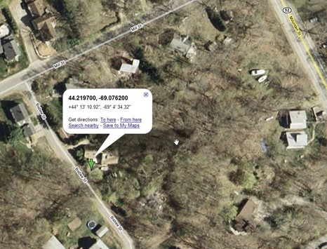
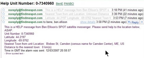
On the other hand, it did pretty well—much better than AnyTrack— recording a two way Portland-Camden road trip, only missing maybe 20% of its every-10-minute track points with only a dashboard sky view. And you can see above and below how well it sent a “Help” message from my driveway yesterday…accurate to about 20’ despite all the wet snow that was glommed onto the trees. According to the manual, SPOT will send the help message and position every five minutes for an hour, thus assuring delivery. You can see below how I got four emails in 40 minutes. Note that the message—“This is a HELP message from…” —is customizable at the SPOT Web site, and might have sent something like, “Hey, dudes, they’re biting over here” to a bunch of fishing buddies. After all, unlike SPOT’s 911 button, the “Help” and “OK” messages only go to your list of email and cell phone text addresses, and no doubt people will think of many unusual ways to use that ability. I’m going to keep trying SPOT, but am really looking forward to Doug Ritter’s testing, which will be much more thorough than mine. I emailed him about it today, and he agreed that SPOT users may find “sky view” critical. His test results, though, are “still weeks away.”


I’m sold on it. Already bought two units. Have setup a unit for demonstration in our store. Have orders for 2 units in just a few days. Everyone thinks it’s a great product. I’m recommending that the unit be upgraded to solar powered and also allow you to save waypoints on the unit its self for later uploading as an option. Also, it should allow you to control how often you automatically track. Say, by time, distance and speed. Like the i.TrekZ1.
Thanks for you great reviews. I check your site daily.
Ari Castano
Advanced Marine Electronics.
Ben,
I’d really like to see an on the water test of the latest version of Google Maps for Mobile; it can determine positions sans GPS by “triangulating” cell towers.
While the pos accuracy is horrible compared to GPS (900-1200 meters here in NYC, though w/out GPS’ issues indoors), it will be interesting to see how accuracy changes as you get further offshore.
I have been using Google Maps on my Sony Ericsson phone (Java Based App) on land for a few months now and love it. I just downloaded the new version that adds your location, but it doesn’t appear to work with my phone which is a real bummer, as that was the one thing missing from the program as far as I was concerned. I use the traffic function every time I drive thru Boston on my way between Newport and Camden.
JGB wrote: “latest version of Google Maps for Mobile; it can determine positions sans GPS “triangulating” cell towers.”
… I don’t think so, what your speaking of might be a feature of the phone itself not google.
Various phone set makers are experimenting with various capabilities to let the phone itself determine it’s position utilizing GPS augmented with other methods (e.g. the method you spoke of, another triangulates off known wi-fi signals in a database, etc.) or use those methods without gps at all.
Capt,
You might try a little ‘vestigating before you start your commentating!
Google Maps Mobile does indeed determine your pos via cell phone towers; download it here (http://www.google.com/gmm) via your phone’s browser, if you have the hardware.
I have a Cingular 8125 (aka TMobile MDA aka HTC Wizard) running WinMo6, which most definitely has no GPS.
I believe you meant to refer AGPS in your 2nd para; this allows a phone w/GPS to use the cel tower to much more rapidly acquire a fix from cold start.
Law enforcement has had the ability for many years to track a suspect via cel towers (remember the OJ chase!) And strangely enough, a 3rd party version of MS Live Local for mobiles allowed you to get a (very) approximate fix via the IP address of a WiFi hotspot to which you connected, if your phone had Wifi, obviously.
I really just want someone to test GMM offshore to see what kind of pos it will give; any takers?
JGB,
I too would have guessed it was the cell company, not Google, doing the locating, but apparently not. Looking at the gmm help files, the availability of the feature has to do with the phone, not the service. Apparently some handsets report the cell they’re talking to, and Google’s figured out how to turn that info into a (vague) location.
At any rate, I’m in no position to test it. I don’t have a very smart phone, and I live on the frontier of cell services. But I’m meeting with Jeff Siegel (of ActiveCaptain) on Thursday. He may have tried this.
It’s my understanding, strictly from media reports, that Google was somehow able to geocode the ID of every celtower in the US; the blue dot “EP” on the GM display is just the location of the tower w/which your phone is registered. I’ve played w/it while walking the streets of NYC & it’s funny to watch the EP jump back & forth several blocks as the phone switches towers.
Also tried it on the Masspike last w/e & the EP never left the highway, so there must be some type of “map matching” built in, too. Anyhow, it will be interesting to see the EP while afloat; I’m frostbiting in Boston on Sat, so I might take 1 or 2 glances at my phone b/w races.
This feature will hopefully be part of Android, Google’s Open Source phone OS; would be great if someone could use it as a source of AGPS in a smartphone chartplotter. There’s a project for Jeff Siegel.
And Ben, no smartphone?!!
JGB,
.. do you agree that google is not performing triangulation?
Capt.,
Google is not performing triangulation; hope the above explanation of my understanding on how it works suffices.
I used the term “triangulating” in quotes w/in my original post, but only jokingly.
I’ll try it out this w/e if my regatta is not canceled & will report the results.
Hi Ben,
Thanks for your comment regarding SPOT. I have got one demo unit testing it in Europe, Italy, France and quite recently one of my friends has successfully managed to send some tracking messages from Kenya, over 2000 km out of the official coverage zone.
I didn’t have a chance to try SPOT in urban canyons (no such environments in the main European cities), but I tried it while traveling across Italy.
Placing the SPOT in my Opel Vectra, close to the large windshield, and activating the tracking function, the success rate during my 570km trip was 100 % (all messages went through).
On the other hand, when driving Chrysler 300, with smaller windshield, the success rate was around 70%.
Therefore, the visibility of the sky is quite important for the successful transmission of the GPS position.
I can also confirm that the accuracy of the positioning is in average 10′-20′.
Very best regards,
Giorgio