
Garmin 5212, what’s wrong with this screen?
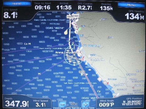
Last week I got a call from Phil, who’s cruising his Tayana 55 down the West Coast, headed for Mexico and beyond. He “loves” his new Garmin 5212, except for an interfacing bug that he’s hoping someone (Garmin?) can help with. Check the photo above, which shows the standard chart display with its dashboard style numerical data. The way that works is that under the Menu key you have four categories of data that you can set to Show, Hide, or Auto (i.e., show only if there’s appropriate data). I know from my own testing that Phil has the “Navigation” either on Show or Auto and hence is getting the info across the top, which is putting him right on his long SE leg toward San Francisco, 9 hours to go at 8 knots. He’s also put “Sailing” data in auto mode (and has the 5212 hooked to his Simrad instrument system), which is why you see not only wind speed and angle along the bottom, but also the wind indicator around his boat icon. I don’t know if he’s set Wind to Apparent or True (or if Garmin can cope with Ground/True subtleties), but the real question is why the heck is that boat icon headed North?
That’s the rub! Phil’s been told by Simrad that its instruments output all standard NMEA 0183 strings, whether it has data or not (which doesn’t make a lot of sense, but is supposedly OK under the standard). The Garmin is apparently seeing a null value heading string coming in and assuming that means 0 degrees North. If Phil disconnects the 0183 connection, the 5212 doesn’t see any heading so uses COG to point the boat icon properly, as seen below. But then he doesn’t get wind, or depth, on his dashboard. Has anyone else seen this problem and/or know how to fix it? Myself, I think Garmin still a ways to go with its NMEA 0183 abilities. For instance, I was surprised the other day to discover that while the 430 mounted on Annie G. is getting most Tacktick data fine, including water temp, it will not show the depth and boat speed info coming from the same triducer. I suppose it could be a Tacktick issue, but I doubt it. And I should add that I haven’t yet updated the 430 to the latest software rev. This, sigh, is how it so often goes with new systems and with 0183 interfacing in general.


Perhaps the Simrad instruments are putting out an NMEA sentence with a null value for the fluxgate compass heading? This would suggest the IS15 instruments are not interfaced to a simrad pilot. Furthermore, the wind direction reading would not be in True without a heading sensor, making it apparent which would be close to 000 if they are motoring at 8-knots. On the picture the wind direction is 009, pretty close. If the wind speed is 3.1 knots and they are doing 8, I assume they are motoring. So, I conclude they have no fluxgate in the NMEA string and the IS15 sentence is screwing up the heading on the Garmin without it.
Thanks for posting this Ben, I am hopeful that someone has the solution to this issue.
I am going to add a NMEA output to my WH Autopilot fluxgate compass in the next month. I have no idea what the Garmin will do when it sees two HDG sentences (although one is null).
Thanks, Jeff. I wasn’t clear that Phil does not have an electronic compass in his Simrad system. But apparently it’s still sending a null heading string, and the Garmin thinks it meaningful.
As for no True Wind without heading, I don’t think so. The Garmin 430 I’m testing in my little sailboat seems happy to turn Tacktick wind info into True without any heading. I presume it uses COG/SOG. Maybe, though, it’s getting True from the Tacktick system, but that doesn’t have a heading sensor either. Tacktick seems to calculate True without one, figuring that the wind sensor is properly oriented to the bow. There’s a wicked lot of confusion about “True Wind” out there.
If you’re using the TackTick Micronet with the Micronet T121 Hull transmitter then you should have a T909 compass sensor, no?
Is this the sort of thing that an all-N2K installation will be able to help with? I’m shopping for instruments now, intending to eventually plot on PC, and looking hard at the Maretron offerings…
For the record, here is some of what I have aboard my Tayana 55 (I am the one with the issue).
Garmin 5212
Simrad IS12 instruments, wind, depth, speed & multiple “Data” repeater displays (There isn’t a fluxgate or gyro heading sensor)
WH AP-4 Pilot (takes NMEA route & cross track output from Garmin)
What the Simrad IS12 instruments are doing, is sending the NMEA sentences for all of the POSSIBLE data types they can offer, one such sentence is the HDG (heading). Simrad sends this data as a NULL value, however it appears that when the 5212 sees the HDG as NULL it believes this is North (000).
Simrad has stated to me that it is permissible within NMEA conventions to send NULL data. I don’t know if it is, but if so then it’s a Garmin issue. If it isn’t permissible to send a NULL value, then shame on Simrad for configuring their IS12 instruments to do so.
Even if it is “ok” to send NULL data, I really don’t like what Simrad is doing with their NMEA 0183 output.
BTW – Jeff got the situation correctly in the 1st reply with the exception of the IS15 vs the IS12 instruments… Great detective work!
Jeff, There is not T909 Compass in my Tacktick system. If you click the last link in this entry, you find a description of the setup (which features a milk crate 😉
Yuri, Yes N2K is generally much better at this stuff…but it is not perfect.
It is a bit of a hack, but you can solve this with the Actisense NDC-2 or equivalent (http://www.actisense.com/HTML/Products/NMEA%20Interfaces/NMEA%20Multiplexer%202/index.php) Just filter out the null heading information.
I vaguely remember that you can control the output sentences of the Simrad autopilot, but am not sure if the same is true of the wind instruments.
Thanks, I am aware that I can use a smart multiplexer to filter the sentences- but I would like to avoid adding components where possible.
You cannot control the output sentences of the IS12 instruments 🙁
Can the fix be as simple as this? The Garmin manual for the 5000 series (available here http://www8.garmin.com/manuals/GPSMAP5008_GPSMAP5000OwnersManual.pdf) on page 35 shows how to turn off and on various NMEA 0183 sentences.
It does not show all of the sentences that can be turned on or off. How about turning off the HDG sentence?
Joe
Thanks, Joe, but that only applies to Garmin’s 0183 output.
And here are some critical comments on the Garmin screen that came in via e-mail:
1) “GPS Heading”. GPS doesn’t give heading, it gives Course Over Ground. Heading does not equal COG as you know, but apparently many others do not.
2) Time to next. Needs units. Sure would be nice to know which waypt they are going to next.
3) Arrival. Needs AM/PM, unless in 24 hour time format.
4) Off Course: 2.7ft. Awfully high precision there. I’m against precision that the user cannot utilize.
5) GPS Position: Sure hope those units can be changed to DMH or DMS. I’m sure they can…
As far as NULL fields, it’s not an 0183 problem, it’s what I like to call “stupid programmer syndrome”. If there is no data, don’t interpret it as data is the general rule.
As to the above…
GPS Heading – agreed, it’s unclear
Time to next – You can change this to distance to next, however routes are not always built of waypoints in the 5212 so it’s time to next turn.
Arrival is 24 hour I believe. However it won’t compute an arrival that is more than 24 hours away, in that case it only displays dashes.
Off course display changes levels of precision depending on how close you are, ie 1.2 ft, 120 feet, .2nm etc…
I know you can alter the output of GPS data, I will try to alter the display and see what happens.
You can alter the NMEA sentences with programmable devices like the Brookhouse MUX
It probably is a bug, because dealing with NULLs properly is a very common problem in the database world that I come from. (Note that the statement “X not equal 5” is not true if X is NULL.)
However, for Simrad to send out a sentence with absolutely no data whatsoever in it is a pretty pathological case. They are forcing the consumer device to process empty sentences for absolutely no reason. You might find that a NMEA filter speeds up the chartplotter a little bit. The time that it spends “downloading” and processing an empty heading is time that it isn’t spending getting position data or listening to your keypresses.
I would not absolutely certify that I would not have made the same mistake that Garmin did. It might not even be all that clear in the spec that you can send an information-less packet. I do not know since I have never spent the hundreds of dollars that they ask for either the 0183 or 2000 specs. (Snark: the ANSI committee produced a much more complex and longer SQL spec with tens of thousands of man-hours of thought into it for the grand sum of free. Why does NMEA charge such outrageous sums for the documentation on something that they hope becomes a standard?)
I am not sure of all the technical side, but with my Garmin 450, if the wind is blowing at me,then the screen says I am going the wrong way, maybe thats the problem. Just a thought for you to check, thanks another little guy.
PS, My Garmin is on my 17 foot seakayak.
Update: Garmin fixed the issue in the GPSMAP 5212, Ver. 3.10 firmware release!