
Real world AIS B #2, the name game
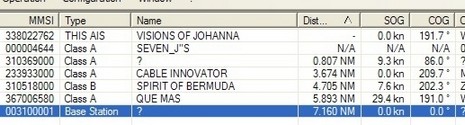
What luck that I got to monitor another active Class B transponder while testing one myself. As you can see above, and bigger in my first Nauticast B post, ACR’s included “Link2AIS Class-B” software identified the training ship Spirit of Bermuda’s AIS as a B model. Coastal Explorer did not make this distinction but it did decipher Spirit’s name and other “static” information. As mentioned in my one offshore post, none of the five ships I spoke with were getting our name on their Class A AIS displays, though they could see our MMSI, position, speed, and heading. We’ve discussed this issue before, and I’ve written about it in several magazines (Professional Mariner most recently), but let’s review:
Class B AIS broadcasts on the same two VHF frequencies as Class A, but using a different organizing protocol (CS versus SOTMA) and different specific messages. The original AIS standard anticipated Class B, and the B dynamic data message #18—the critical MMSI, position, etc. stuff—should be understood by most every existing AIS receiver/plotter (NASA’s the glaring exception). However, Class B static data message #24 is a relatively new development (as a result of changing to the CS protocol, a story we’ll skip today ;-). Hence, we have all those ships that could see Visions of Johanna as an AIS target but not her name, call sign, dimensions, and vessel type. This is a shame, and really bothers some new Class B owners. One in fact has volunteered to build a list of AIS plotters that do not yet understand Message #24, in part to encourage manufacturers to offer updates, and I’d be glad to post it here on Panbo.
But I sure hope that this name glitch doesn’t discourage boaters considering a Class B transponder, because I don’t think it’s a critical problem. For instance, if a ship does see you on its needs-to-be-updated AIS display and wants to talk, the bridge officers can always use your unique MMSI, either verbally or electronically. Sure beats the old “Yo, north-bound vessel at xx xx.x N, xxx xx.x W.” By the way, note the “base station” also shown in Link2AIS above. That’s the wonderful Bermuda Harbor Radio station at Fort George. I was still getting its signal 75 miles north of the island, which would make it a terrific any-weather aid to navigation, if your AIS plotter can decipher it (base stations use another special message) and if the site was clearly charted as the base station.


Thanks for the great material you write. We mentioned your work on the zeus platform on this mornings episode.
http://www.ifilm.com/video/2870742
Enjoy and thanks!
A matrix of interoperability / compatibility between various mfgs/models, both A and B would be a great buying guide! Perhaps a Wikipedia entry?
Note that the NASA AIS Engine can be updated to receive #18 and #24 messages. One can buy an updated chip at very low cost. A rather crude way of updating, but it does work. I have no info whether the same is true for their “AIS Radar” product.