
Remote bottom mapping, who but Lowrance?
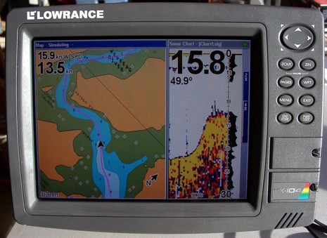
Here’s an interesting question: “I am looking for a combo GPS/Sounder for my dinghy, which will record depth data along the GPS track (so we can go out, find the channel, and then bring the dinghy GPS/Sounder to the mother ship and follow the track/depth data).” I can’t think of any truly portable solutions that would work in a rowboat, but I happen to know that this man’s ‘dinghy’ is actually a center console skiff. And that means that any of Lowrance’s recording GPS/fishfinder units, like say a 5” LMS-332C, might do the job. For years now, Lowrance combo units have been able to record your GPS track and sonar imagery to an MMC/SD card (and now to the 20gig hard drives in some units). You can play chart and sonar back on the display itself, split screen like below, or you can put the card in a reader and watch just the sonar scroll on your PC using free viewing software. The picture below (and bigger here) is me trying this feature a few years ago in some skinny Maine waters, and it worked quite well (note: that’s a Navionics Gold chart, not a Lowrance NauticPath). And, by the way, you can also play the recordings back in the nifty PC Product Emulators that Lowrance also gives away. But all this might be overkill in terms of collecting soundings in a poorly charted anchorage. Does anyone know a neat way to collect a depth/position data stream from a small boat, then display it nicely on an electronic chart?


Why not just invest in a Interphase forward looking sonar installed in the “mother ship”? Seems that would provide you with the same information without having to go out exploring with the dinghy.
Hmmm….methinks this could be useful for my fishing habit
Coluld you use something like this to update the chartcharts for remote islands?
Some people do use FLS for this purpose, Dale, but it is limited in how far it can see. The Lowrance idea is not the best solution, but I can’t think of anything better. I like the idea of being able to take soundings in a little boat and then plot them back on the big boat. How about a ‘smart’ depth transducer talking to a small or even handheld plotter, able to create and save tracks with soundings attached, which can then be transfered and displayed by the mother ship’s plotting system, preferably as a track whose colors indicate depth? Can anyone do that?
Seems Nobeltec released a similar function yesterday. Their new Bathy recorder …
http://www.nobeltec.com/products/prod_bathyrec.asp
Yes, I saw Bathy Recorder at the Boat Show and it looks great. MaxSea/Furuno, Simrad, and some others have similar programs. But none solve the “collect data with small boat” challenge (I don’t think). Maybe it’s as “simple” as putting the NMEA depth and GPS info into Ethernet and WiFiing it back to the mother ship?
Or log the NMEA data on a SD card on the PDA, then replay this to your Bathy app on the mother ship. NMEA logger/replayers are available, dunno if they exist for PDA though — and it would remain a home-brew hacked-together solution.
My guess is that there isn’t a big market (otherwise it’d be covered already!)
Ouch! $800 just for Nobeltech’s recorder software? This in addition to the amount they gouge for Admiral? No thanks.
Nobeltec seems to be out of touch with their pricing. They gouge the customer an extra $100 for a repackaged Nasa AIS receiver and until recently one had to spend over a grand to get their AIS plotting software. They require the customer to buy their expensive proprietary charts. I think I will pass.
I know this post is old but for what it is worth:
I am developing software that may match the needs mentioned in the original post. At the time of this reply, I am just 2 months away from a launch and the web site is just being drafted but you might get the idea at Burlison Technologies. I haven’t decided on the pricing but probably $200 or less.
The already existing affordable option:
http://www.drdepth.se/
Can be used live with NMEA data or with postprocessing of recorded data (for example Lowrance/Eagle sonar logs).
Happy mapping!