
Navionics Platinum, interesting details
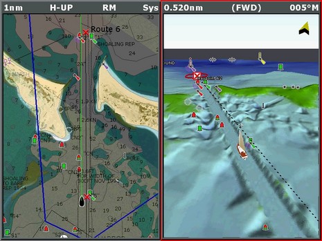
I recently took some screen shots of DAME award winner Navionics Platinum, which is surprisingly simple to do on the Raymarine E series. You just hold down the ‘data’ button until you hear a beep, and a full resolution (800×600 pixels, in the E120’s case) .bmp file will be saved to the CF card. At any rate, the full res version of the image above is here. That blue line on the left side marks the angle of view that I’ve set in the 3D image to the right. You can rotate and move around in that 3D view all you want, plus change its zoom and pitch, or you can simply synch it to the chart view.
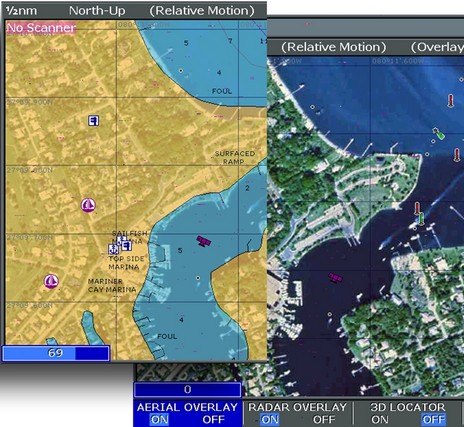
Note too how the area around the channel is much more detailed than the chart soundings; it looks like you can even see the bite marks of the dredge. Navionics, like everyone else, is pretty tight about where it sources data, but I know that the Corp of Engineers does extremely high resolution surveys during dredging projects, and I think that’s what we’re looking at. {Wrong, it turns out; after speaking with someone at Navionics I think that it’s more likely that this is just an ‘effect’ that Platinum applies to any dredged channel.} The left window, by the way, is a blend of photo map and chart, as I discussed earlier. I’ve notice unfortunately that all the photo maps north of New York State are black and white, exactly like Maptech’s, which are based on USGS files (which probably explains that source). Below (and bigger here) is an illustration I made trying to show how the variable blending works. On the right side you can see how nice the color maps can be.


I think a completely up-to-date chart from a reliable source (NOAA) is far more valuable than all these bells and whistles.
As sailors we like to say “head out of the boat”. One does not want to become so bogged down with a “virtual world” missing out on the real world.