
Garmin 376C, holy mackerel!
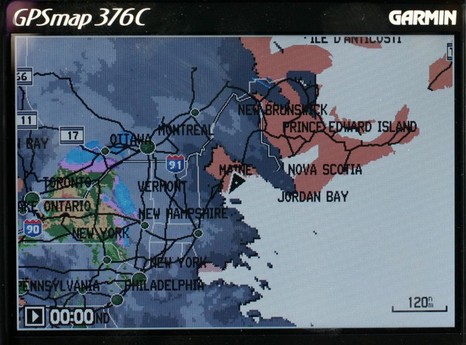
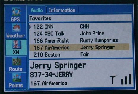
I would have posted earlier today, except that fooling with this Garmin 376C vividly reminded me (above, and bigger here) that the spell of dry, sunny weather was about to end. So I spent some hours winterizing the fleet, all the while watching the clouds thicken up from below and above. I could also see an animation of all that rain moving across New York state, plus the lightning strikes, the frontal lines, pressure gradients, wind predictions, buoy reports, etc. etc. It is phenomenal how well you can see all this info on the 376’s little screen. The display itself is exceptionally bright and detailed, and Garmin has also done a good job at letting you view the weather data mixed together or one element at a time. And, get this, I was also listening to XM radio (below). I’ve been trying the 376C intermittently over the last month or so, and am very, very impressed. It really makes sense in terms of carrying your XM weather and audio subscriptions with you on land or sea. The only con I can think of is that BlueCharts have gotten pretty expensive relative to the competition, but maybe that will change.
The Garmin 276C was one of my 5 Sail magazine “editor’s picks” for innovative, important marine electronics introduced last year. I’m working on my 2005 picks right now, and the 376C is definitely a contender. If you have suggestions for other hardware or software that should be on the list, please let me know.


For the last few years the Garmin models have lacked a “Goto” button making activation of a waypoint a bit tedous requiring one to go through several menus. As such I stick with my older Garmins GPSMap175, 48 and 12 models.
I have a 276C and the folow on 376C weather support is fantastic, but not for South America, due the lack of XM coverage. I like the Garmin units because they are very well designed and have the better user friendly software I know. The only thing I would like to have on my 276C by now, is the AIS receiver support for the NASA AIS engine (or other low cost NMEA receiver) like the Si-Tex plotters.
I’ve used the Garmin 396C (aviation) unit and it’s superb. The 376C is the same hardware, less the aviation database and functions – I just ordered one today. Once again, Garmin leads innovation in the handheld market.
Ben – two questions. Garmin has announced their new 3200-series chartplotters (for March 2006 delivery)…and they’re preloaded with Bluechart cartography.
1. Have you seen detailed specs on these units. Will screen resolution be better than the VGA of their 3010 series plotters? VGA is just not competitive in this market segment and is particularly glaring on a large screen like the 3010/3210.
2. And, critically, is there any indication that Garmin will support NMEA 2000 on their Marine Network? As of now they don’t and though I recall seeing an interview where an exec said something like “we’ll see what customers ask for”, I’ve seen no movement, hint, or anything else suggesting they’re moving that way. They’ve long preferred the proprietary route though early on they realized they had to support non-Garmin sensors on their aviation products and now do so well. Are they moving to that thinking in the marine market?
Would appreciate any insight.
Wow, R.O., you’re on top of things. Just moments ago I got some press releases about all the new Garmin marine products being introduced at METS tomorrow. The 3200 series is included but screen res is not specified, meaning it’s probably still VGA (though who else has a 10″ plotter greater than VGA?). Nor is NMEA 2000 mentioned, though some new smaller units are getting something called CANet, able to connect plotters to fishfinders. More soon.
I checked with Garmin and 3210 is VGA. I still can’t think of another 10″ display that is better than VGA. (Of course, the Raymarine C120 & E120 are SVGA. Is that who you mean as competition?)
As for NMEA 2000, Garmin says, “As far as NMEA 2000, we see that protocol as valuable for engine instrumentation, fuel flow, etc., but not useful for the bandwidth required for radar and sonar. Your reader hasn’t seen much ‘movement, hint, or anything else’ about NMEA 2000 plans because, as you well know, we like to keep our R&D to ourselves.” Hummm?
Ben – thanks for the follow-up.
On the resolution issue, I do tend to think of Raymarine’s E120 as a central competitor to Garmin 3010/3210 boxes. Yes, the screen is bigger – but for each it’s their “top of the line” in their network offerings. And, while I have no problem with the 3010 being VGA – it was afterall introduced over a year ago – to be introducing a new, top-of-the-line “large” screen in March 2006 at the same res certainly doesn’t sound like leadership. Ironically, the relatively poor resolution of VGA is, of course, more dramatic on the 10′ screens than the smaller ones.
On NMEA 2000, while we can agree/disagree on which sensors deserve network bandwidth, I think the issue is one of commercial philosophy. Garmin clearly wants to control/sell as many “peripherals” as they can, but they don’t and won’t offer everything and can’t be best of breed in everything (though I’m a big fan of their aviation products)…but by closing their system and not supporting what is shaping up to be, IMHO, a major format force (NMEA 2000) they really put their prospective customers in a difficult position. If I’m inclined to be a Garmin Marine Network adopter and I want to buy one of the new NMEA 2000 weather sensors, I need to buy a non-Garmin screen to display the data and can’t show it at multiple help stations w/o a separate network infrastructure, paralleling the Garmin network. And engine monitoring is not a trivial issue – I’m a bit surprised by the Garmin spokesman’s seemingly dismissive tone on that.
All that said, Garmin is a very smart and very competitive company. They eventually embraced non-Garmin sensors in their aviation line. I hope they do, very soon, in the marine market as well.
Thanks again.
Well said, R.O., though I do not pick up the “dismissive tone”. I’m confident that all electronics companies see the value of networking with boat engines. Call me a bloomin’ optimist but I’m wondering if this CANet business might be a step on the way to NMEA 2000 support. At any rate, I told my Garmin contact today that I’m glad customers like you are speaking up for NMEA 2000, and I’m told that a number of folks at Garmin read Panbo.
I understand that NMEA 2000 is the required standard for AIS and I would therefore never buy a network chartplotter if it didnt’ have NMEA 2000 compatability.
Someone gave you bad info about AIS & NMEA 2000. Right now all AIS transponders and receivers are using NMEA 0183. NMEA 2000 could make installing a transponder much simpler, but a NMEA 2000 transponder doesn’t exist yet.
I have checked details of the NASA AIS engine. This is only one of two AIS receivers I have seen available for leisure marine use and this requires NMEA 2000. I have also spoken to a NASA representative who stated that NMEA 2000 is the standard for AIS. I would love to find a AIS receiver I can use with Garmin products – please advise if there are any !
Yipe. Again I don’t understand who you are talking to. I have tested an NASA AIS engine and written about it here; it does NOT use NMEA 2000. Also no Garmin products yet use NMEA 2000 or display AIS targets.
Pleae check out the NASA website that states it uses NMEA 2000. This does seem to contradict what you are saying, but may be I have made a mistake somewhere.
http://www.nasamarine.com/AIS/AISENGINE.html
Well I’ll be damned; it does say NMEA 2000, twice in fact! But it’s wrong. 2000, for instance, does not run at 38400 Baud. I wrote NASA a note; they’re confusing people.
Thankyou. I would be interested to hear of any explanation you receive from them.
A respected marine retailer told me Lowrance is for the freshwater market. But the products they demo’ed for me at the ACBS were pretty impressive. Large, bright, high resolution displays. Choice of maps, Lowrance or Navionics. NMEA 2000 support. Use of standard MMC/SD cards. The menus are intuitive and easy to use. All this at moderate prices. What am I missing? Why does everybody “know” Garmin, Ray, or Furuno are better?
You’re not missing much. I have a whole network of Lowrance gear here and it’s quite good, especially given the prices. I hope to post more about it here soon.
Purchased a 376c and Xm weathers”Sailor” package. “Surface wind” information is consistently 8 hours old. When I contacted xm to tell them they said its not their problem and to contact wxworx or garmin. You might as well pay $1000.00 for yesterdays newspaper. It’s absoulutley useless.
Something’s odd. That surface wind is model data, not real time observations, and I think it should be coming for your current time plus a couple of forecast times. Are you sure you’ve figured out all of the 376’s data controls? By the way, you should be getting near real time wind speeds for a some locations when Surface Observations are turned on. Unfortunately your package does not contain bouy reports (which, in my opinion, is chintzy of XM).