
ActiveCaptain Mobile, in Beta at last
I’m truly excited about the imminent release of ActiveCaptain Mobile, the long awaited heir to the Outdoor Navigator (ON) PDA & smart phone charting program that went dormant two years ago. Of course we got some big hints when developers Jeff and Karen Siegel introduced the ActiveCaptain (AC) web site about a year ago. Now 5,000 boaters are registered there, and together they’ve made some 150,000 updates to its visual database of marina, anchorage, etc. cruising info. So the idea of ActiveCaptain Mobile (ACM) is to be not only an ON-style mini-plotter but also a live-anywhere connection with the AC database.
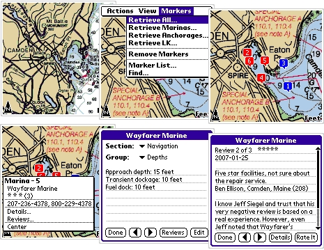
Jeff demoed ACM to me in December, and it’s stunning. This time around he’s preprocessing the NOAA charts by region so they download to a phone as one file and ACM opens, pans, and zooms at lightening speeds, even on a modestly powered Palm Centro. ACM now also has a “course up” display mode, especially important on a tiny screen, and can import/export routes with Coastal Explorer and other PC charting programs. But the stunner is using a data-enabled phone to query, even edit, Active Captain as seen in the series of screen shots above (which happen to illustrate an ironic turn to my Camden boosterism that I wrote about when AC launched).
ACM for Palm devices just went out to Beta testing (volunteers should contact Jeff), and will release in February, with a Windows Mobile edition coming a few months later. The $50 cost will include any or all of 14 U.S. chart regions plus regular program and chart updates for one device as long as you own it. In other words, the software and charts will be locked to your specific phone, and you will have to repurchase ACM when you change phones. But that’s an unobtrusive way to protect software, and the protection is needed as the Siegels negotiate for foreign chart coverage. In fact, they’ll have charts of the U.K., Netherlands, and the Bahamas available by June, and at quite reasonable costs, like under $20 for the whole Bahamas.
And just think where the ACM/AC relationship can go. For instance, a GPS/ACM equipped phone could easily send track positions back to ActiveCaptain where your family, or all members, or your cruising buddies with their smart phones (your choice) can follow your cruise. Jeff is planning to experiment with this and some other neat features for ACM 1.1. Remember though that you don’t have to mess with smart phones to enjoy the free computer-accessible benefits of AC at home or on the water. As of today, these also include some 3,000 new “inlet” local knowledge markers, behind which are some 2,500 pages of info (from the official Pilots, I think), as illustrated below (bigger here). Still, though, the most valuable info on AC is being put up by boaters like you and me. Which is why I hope you get active on the site, and tell your cruising friends about it.


All good, except licensing to a particular device. Cell phones have a very short life, two years at most, less for the technologically inclined who are likely to be the customers.
There are a number of better models out there for licensing / control of proprietary content. Tying it to a device is one the poorest and will cause both them and their customers no end of grief.
$50 each time you replace your phone, is still cheaper than buying the printed guide book every other year … and instead the information about each location overlayed with the maps are up to date, in some cases corrected as recently as the day before.
Very impressive.
In regards to active captain website … winter is a great time to become a first time contributor to the community, and share with others information about anchorages and harbor’s you have visited last season.
Active captain also contributes to my efforts to go green. I have stopped purchasing the thick regional guide books, which are out of date despite the appearances they give the that have been recently updated … and are unhelpful in some respects as they are far to generous on praise (supports advertising model) for every harbor and community they provide local information on.
For example, if you look up Danford’s in Port Jefferson (Long Island Sound), you will find warnings about a particular establishment that no guide book has printed to my knowledge.
I think the wiki approach to cruising info is the way to go. Printed media can’t possibly stay current… like the phone book, out of date the minute it is printed (and therefore mostly/often useless).
I don’t want to use AC in a phone format, since my cell is used for calling only and not web based information. But I do have an IQue 3600 from Garmin which has charts, roads and so forth. What I would like to see is that the AC data is integrated into the Garmin BlueCharts so that whenever I sync my IQue it updates all the new data in AC, much the way ITunes updates the IPod at each sync. I don’t need the charts, nut the wiki type POI so to speak.
Can we expect something like that from AC?
Truth be told…I emailed my mother the URL for Ben’s posting. It’s the 21st century equivalent of buying 5 copies of the Rolling Stone for her (you have to be a certain age to get that).
DefJef, a couple of things…
We have gotten the request to have offline AC data (for the web site too). I definitely see the benefit and I’m not completely against it. I’d just rather get the online connection going first.
Offline, it would be easy to hold the index and position of each marker with very basic information (phone number, address, stars, etc). It would take a lot of space to hold, let’s say, all detail/review data for the Chesapeake Bay. What gets messy with offline data is the synchonization issue it creates with many hundred of megabytes especially if we want user updates offline too. All of those issues go away when the overlay data is all online.
The thing is, online access is getting much more reliable and less expensive. Even here on the coast of Maine, I have no problem connecting to AC with my smartphones. The demo that Ben talked about in December took place over lunch in Rockland, Maine, 2 blocks from the Penobscot Bay. Access took about 1 second for each transaction.
I have more than my share of PDA’s. There is something very nice about only carrying around one device – one thing to power, charge, hold. And most people don’t realize that you can be talking on the phone while you’re connecting digitally (with newer smartphones).
One other thing for Russ…we have total control over the license for the ACM software. If someone gets a new phone, we’re not going to make them pay for a whole new copy of the software especially if it’s been a short amount of time. The alternative is to charge for every update. I HATE that method of software licensing – I’m a customer of a lot of software too. I think that people want access to the latest versions and I don’t think anyone should have to pay for bug fixes.
The international charts are a different matter. We’re not in complete control over those licenses. I wish we were. I just signed 200 pages of contracts with governments who make it very clear that they will enforce their requirements! That gets my attention. We will have to charge a completely new license fee for charts that we pay royalties on. Our idea there is to keep the price down to the royalty itself making it inexpensive to move to a new device. Balancing that is that we’ll provide all chart updates for the license for free (updated every 6 months). You don’t see that model very often.
Jeff,
The one device thingy cuts both ways. When it fails, it takes a lot functions with it!
I use the Ique as a back up and handy cockpit device to see where I am and so forth. I don’t do any route planning or navigation to a waypoint with it. I use it in my car for navigation and it carries all my contacts info as well as calendar (much like a smart phone). I pay less than $50/mo for cellphone with direct connect and hardly use it anyway.. mostly for calling OUT so it is often not even turned on.
I take the IQue on board and pop out the card and blue charts display… street nav is on the card. I only use the thing when we are sailing and then it is plugged into 12v and charging and safe under the dodger. It’s not marinized so I need to keep it dry.
I can recognize that the data would be large to store, but I would be OK with using the region I am sailing in saved to a card. This might limit the size of the data file. I’m not a geek and I don’t know about these things. So I envision, syncing the AC to the card before we head to the boat with the latest info for the region we are sailing in.
I not even sure how far cell coverage extends over the water, but I suppose that within a few miles you can get uninterrupted coverage.
For me it would mean a new expensive smart phone and additional monthly charges for service.
While receiving email while walking down the street in NYC is appealing and important for some, it’s not for me. It can wait until I get to a (usually my home computer) since I work at home (when I work).
We recently purchased a laptop which we can bring aboard and if there is wifi I suppose receive email and AC. But I think running laptops on a sailboat is still a bit nuts from the power consumption perspective, the fact that they are not marinized and I have perfectly good redundant purpose made fixed mount marinized nav gear. So they are fine in port and for the occasional offshore use for download GRIB files and email.
I sense we are getting close to a wireless connectivity from anywhere that is affordable, reliable and inexpensive. We are not there yet and each new device is typically a monthly fee subscription deal and frankly I am monthly subscriptioned to death.
Look at some of them:
Sat TV
cell phone
sat phone
cell phone internet
high speed internet land
land line phone
sat radio
XM weather
private weather routers
YIKES!
Jeff: Your challenge is to figure out which devices and in which order. This may not be entirely obvious.
The iPhone is a great example. In the last five years I’ve owned four phones with web access, but the iPhone is the only one that really worked and that I’ve used consistently, the others just didn’t work well enough to be used regularly.
This was evidenced by Google’s report that the iPhone continues to generate traffic totally disproportionate to it’s market share and is exceeded only by Symbian systems. The point is that it’s not whether the device is capable of accessing the net, it’s whether people actually use it.
I think the message is that users want access to the information from a variety of devices (PDA, smartphone, laptop, etc.), both online and offline.
I think offline access is very important and I am willing to pay for content.
I almost chimed in to agree how helpful an off-line access could be, but the wiki/community contribution aspect of the software will be very difficult to duplicate on an off-line model, and if off-line users instead got read-only access to the content without having a seamless way to correct and contribute information, they probably wouldn’t make the effort to contribute. It would almost seem unfair to the rest of the community who labors (even if only a little bit) to enter and update information, while others get an off-line experience and don’t contribute.
This probably didn’t come out right, or maybe I am a little jaded that I have provided a majority of the reviews that appear for my local region without other local captains yet reciprocating.
In any event, while I too would like to get the content off-line, I think perhaps Jeff should sail the course he originally planned rather than take a detour to provide off-line access.
How do you make the leap that offline users are not contributors? There is nothing mutually exclusive about contributing to the wiki and wanting to have offline access to data.
I think it’s very desirable to have destination data BEFORE I arrive at the destination and sometimes I change my destination while underway. It’s nice to know as I approach that harbor that they’re monitoring 72, or prefer to be called on a certain phone number.
My experience in the content business is that once you have content, you want to get to as many people as you can, not hold it close to the chest.
I am not sure I see the problem with an off line directory. It would need to be validated on line on occasion; e.g., the Microsoft model. You install the software you have to validate it. Someone else has installed it then no validation. The one thing I would add is to allow me to give up my validation and disable the software. This does not work for the “Computer dies crowd” but it does work for the other 90% that up grade our computer. A for the file size. Let me select what to download – region, country, world and give me an approximate time to download. You could even make the download time artificially large for the larger areas to discourage people who do not need to download these areas from doing such. I am in Florida do I really need charts for Seattle Washington on my computer?
As for the data upload. When I return to the marina I have a WiFi connection. If the application had a schedule it could arrange to have the data sent at non-peak times. I would even be willing to integrate my depth sounder with my computer to give you more data about the depth where my boat visited. This could be compared against a tide table and more accurate charts could be automatically generated.
This is a really neat application and if marketed correctly you could have the most complete database of charting data that could be sold to others.
I made the leap based on my experience at work (unrelated to marine industry). Our staff collaborates on best practices in configuring our software product via a wiki. Although it’s easy enough to get a copy onto a laptop to travel with us, any changes we make in the field would be lost unless we connect to the original wiki back in the office over the internet before making changes.
I entirely agree it’s very desirable to have offline access to the data, it’s a great idea, but in the event it’s wildly difficult to provide an off-line version, IMHO the wiki that Jeff has deployed is quite innovative and usable at home while I am planning trips, and only gets better with wireless.
I like the on line version. I would never rely on it for navigation. My mobile operator once thought that “can you hear me now” was a good advertising campaign. It was more of a statement of the connection reliability of the network. I will take an off line navigation tool when I am entering a tricky harbor at night.
I was just reading my comments, and realized the context isn’t so clear. My fault, sorry. Please re-read my positive posts about Active Captain in the context I provide here …
I have dual networked Raymarine E-80’s with Navonics platinum maps and paper maps on my sailboat. In addition, I have one or more 8 1/2 x 11″ printed maps from my home Mapsource software and Blue chart maps for any new harbor I am pre-planning to visit for the first time. I would’t enter any harbor other than my home harbor, at night, unless for a medical emergency. With all these backups, I don’t look to Active Captain for navigation information at all except maybe to find comments other captains have about the approach depths to fuel docks and slips.
The information I primarily seek out of Active Captain is to learn from other boaters about points of interest in places I visit. Information about specific marina’s services and costs, VHF channels, nearby entertainment and restaurants. Yes, it’s really helpful to use the overlayed google earth maps in helping to understand the location of anchorages and marina’s and their proximity to points of interest on land, but that’s it … I would look up detailed maps on my home Mapsource or boat’s Navonics maps for actual navigation info.
Once more information is populated, I look forward to potentially learning information about the approaches, navigation markers that are damaged, etc.
In this context … the application of a wiki to build an on-line community of boaters to share experiences is my biggest take away value. When I can have wireless access to this from my boat, it will be even better as I can learn about locations I had not pre-planned to visit. Especially I am looking forward to wirelessly searching for anchorages on short notice that meet a criteria I can pre-set.
Compare to the 2004 Guide Book to Long Island Marina’s I last used, I found:
* 1 in 3 Restaurants didn’t exist any more. Not an issue with Active Captain.
* One of the fuel docks I visited was misprinted as having diesel, when it only had gas. Not an issue with Active Captain, and Active Captain will provide current fuel costs if updated by local boaters.
* The restaurant’s listed in the guide as being in walking distance to the Marina’s was wildly exaggerated in nearly every case. (With google earth / active captain, I can actually see the locations and communicate accurately to my crew how long they have to walk)
* Marina services information was entirely inaccurate. (pricing, depth of slips, working showers, etc.)
* Local attactions are incorrect also. An attraction that was the focus of visiting Old Saybrook in 2005 had since been closed for six years at the time of our visit.
* Every location was listed as beautiful, even if it was dilapidated. For example a marina on City Island. (incidentally that marina was fixed up, and the info about it was posted by another captain in ActiveCaptain, something that wouldn’t appear in the guide even if they originally printed that it was dilapidated.
In this context … would I like an electronic copy on my PC and avoid loading on my cell phone, yes. But I strongly believe the technological approach taken by Jeff in creating this innovative service / community is on the right track and is beneficial to boaters without an off-line feature set. As it turns out my mobile, a blackberry, isn’t supported, but I will continue to be an active member of this wiki community and will look to perhaps replace my blackberry. Not just IMHO, but I say this as one of the top 100 contributors. (Is that still the case Jeff ?)
I suppose that the issue is real time AC on board which is not PC based.
I have added reviews to many locations I have visited and will continue to do so, but my reports may no longer be current.
I don’t use a laptop for navigation on board, if fact, we just got a laptop which isn’t even populated with software, let alone files yet. It will have its first visit to the boat this Spring.
I would like to get the AC data onto my existing nav instruments/chartplotters which are a Ray C, a Horizon CP170 and a Garmin IQue3600… in technology terms dinosaurs, but to me still marvels.
I am not about to upgrade perfectly function and quite advanced gear (I come from the days of LoranC). But I would like to get that AC info onboard in my local region or where I am cruising to. I don’t want an expensive new cell phone and plan… I hardly use the phone I have.
Can you geniuses at AC please give me a way to enjoy the data.. which I am more than willing to continue to support… on board without getting into a new phone and plan? Is that asking too much?
I wrote a second comment yesterday that never popped up. I’ll never be as eloquent as I was in that post!
Anyway, offline data…
I get it. It isn’t asking too much. There are about a dozen people who have asked for it. It will happen but I have to finish the online part first. I can see offline data being supported in three waves: 1) markers and basic info only (phone number, name, address), 2) adding details and reviews offline, and 3) adding the ability to update offline (with syncronization). It’s the synchonization that scares me – it’s a difficult thing. Consider that you’ve downloaded a region of markers and change something offline. In the meantime, someone changed it online. I now have to have some type of interface to help you decide whether that update should really go in. It’s not impossible – just messy. None of those issues exist when everything is live.
b393capt – yep, still in the top 100. The top 10 all have over 1,000 points – you’re at 1,300.
Here’s what I’d like to see…
I hope that the mobile phone versions will provide remote use of the marker information and an excellent chart backup system (with GPS support if desired). I just loaded every chart in the US onto my Tilt last night – more than 2,000 charts. I was just exploring some of the coast of Alaska over lunch – really incredible to have all that data in one place. I think it makes a pretty good backup – maybe even reducing the need to have all those paper books of charts (I have more than my share and I’m not getting the latest updates this year).
But here’s the next step with it all…
I’m hoping the mobile phone version will show that any internet connection has a way to pull the marker data down live quickly and efficiently. These mobile phones have tiny CPU’s. The server does on-the-fly compression to move the data quickly to the device. But why does that device have to be a phone? Why couldn’t it be your Raymarine chartplotter or Furuno NavNet system? Obviously it would take some work by those manufacturers but I see a day when you’ll plug your phone into your chartplotter to get over-the-air data right on the built-in system. Everything on our web site is built around allowing that to happen – it was the original vision to solve the issue of having good point-of-interest data. And again, the mobile phones are just one implementation of it to hopefully kick Garmin, Raymarine, etc. into thinking about it!
I hope this post makes it up – I’m copying the text in case it doesn’t.
If the marker data comes down live and efficiently to our chartplotters, then in effect all the past USCG notices to mariners back many years and as recently as yesterday, can be instantly applied as corrections to the charts in our chartplotters.